Carnan Cruithneachd

Last updated
Carnan Cruithneachd
Seat, Glen Elchaig - geograph.org.uk - 1353811.jpg
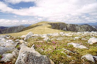
Carnan Cruithneachd from Glen Elchaig
Highest point
Elevation 728 m (2,388 ft) [1]
Prominence 220 m (720 ft)
Listing Graham, Marilyn
Geography
Location Ross-shire, Scotland
Parent range Northwest Highlands
OS grid NG995258
Topo map OS Landranger 25, 33

Carnan Cruithneachd (728 m) is a mountain in the Northwest Highlands of Scotland. It is located in the Kintail area of Ross-shire, on the southern side of Glen Elchaig.

The Northwest Highlands are located in the northern third of Scotland that is separated from the Grampian Mountains by the Great Glen. The region comprises Wester Ross, Assynt, Sutherland and part of Caithness. The Caledonian Canal, which extends from Loch Linnhe in the south-west, via Loch Ness to the Moray Firth in the north-east splits this area from the rest of the country. The city of Inverness and the town of Fort William serve as gateways to the region from the south.

Kintail mountainous area in the Scottish highlands

Kintail is an area of mountains in the Northwest Highlands of Scotland, located in the Highland Council area. It consists of the mountains to the north of Glen Shiel and the A87 road between the heads of Loch Duich and Loch Cluanie; its boundaries, other than Glen Shiel, are generally taken to be the valleys of Strath Croe and Gleann Gaorsaic to the north and An Caorann Mòr to the east. Although close to the west coast the mountains lie on the main east-west watershed of Scotland, as the northern side of Kintail drains via Glen Affric to the east coast.

Ross-shire Historic county in Scotland

Ross-shire is a historic county in the Scottish Highlands. The county borders Sutherland to the north and Inverness-shire the south, as well as a complex border with Cromartyshire which consists of numerous enclaves and exclaves of the latter scattered throughout Ross-shire's territory. It includes most of Ross as well as Lewis in the Outer Hebrides. Dingwall is the traditional county town. The area of Ross-shire was based on that of the historic province of Ross, but with the exclusion of the many exclaves that formed Cromartyshire.

The peak has a very steep northern face, but its other side's are more gentle and form a gentle plateau. The nearest village is Dornie to its west. [2]

Dornie Scottish village

Dornie is a small former fishing village in the Kintail district in western Ross-shire Highlands of Scotland. It is near the meeting point of Loch Duich, Loch Alsh and Loch Long.

Related Research Articles

Sgùrr Mòr (Fannichs) Mountain in Northern Scotland

Sgùrr Mòr is the highest of the nine Munros in the mountain range known as the Fannichs in northern Scotland. This range is located between Loch Fannich and the A835 Ullapool road — a remote area with few habitations, but these Munros, which are usually climbed in groups or occasionally in a single hike, are mostly gentle sloped and fairly accessible from either of these locations. If approached from Loch Fannich, a bicycle or permission to drive on the private road would be helpful.

Sgùrr na Cìche 1040m high mountain in Scotland

Sgùrr na Cìche is a mountain in the Knoydart region, in the west of Scotland. It lies on the edge of Knoydart in an area known as the Rough Bounds of Knoydart.

Beinn Fhada 1032m high mountain in Scotland

Beinn Fhada or Ben Attow is a mountain in the Scottish Highlands.

Fionn Bheinn 933m high mountain in Scotland

Fionn Bheinn is a Scottish mountain located south of Loch Fannich in the north western highlands. It has a height of 933 m (3061 ft) and is listed as a Munro. The south side of the mountain is a shallow, smooth grassy slope, but its north face is steeper and is considered more impressive.

Gleouraich 1035m high mountain in Scotland

Gleouraich is a Scottish mountain located to the north of Loch Quoich in the north western highlands. It has a height of 1035 m (3396 ft) and is classed as a Munro. The mountain's main aspects contrast with each other; the south side of the mountain is a gentle, grassy slope, but its north face is steep, dark rock, with a complex array of ridges and corries.

Sgùrr a Mhaoraich 1027m high mountain in Scotland

Sgùrr a' Mhaoraich is a Scottish mountain located to the north of Loch Quoich in the north western highlands. It has a height of 1027 m (3369 ft) and is classed as a Munro. Viewed from Kinloch Hourn to the west, or from the north, it shows large, steep, rocky flanks with a complex series of ridges and corries, but like its neighbours such as Gleouraich, its southern side is gentler and grassier.

Aonach Buidhe

Aonach Buidhe is a remote mountain in the Northwest Highlands of Ross and Cromarty in northwest Scotland. The nearest village is Dornie.

Beinn Lair

Beinn Lair is a mountain in the Northwest Highlands, Scotland. It lies in the Letterewe estate on the northeastern shore of Loch Maree in Wester Ross.

A Ghlas-bheinn

A' Ghlas-bhienn is a mountain in the Northwest Highlands of Scotland. It lies in the Kintail area of Ross-shire, close to the settlement of Morvich.

Aonach air Chrith Mountain in Scotland

Aonach air Chrith is a mountain in the Northwest Highlands, Scotland. It is located on the southern side of Glen Shiel in Kintail.

Ruadh-stac Beag Mountain in Scotland

Ruadh-stac Beag is a mountain in the Northwest Highlands of Scotland. An outlier of the Munro Beinn Eighe but a mountain in its own right, it is located in the Torridon Hills of Wester Ross.

A Chailleach (Fannaichs)

A' Chailleach is a mountain in the Northwest Highlands of Scotland. It lies in the Fannaichs of Wester Ross.

Garbh Chioch Mhòr

Garbh Chioch Mhor is a mountain in the Northwest Highlands of Scotland. It lies in the Lochaber region, between Loch Nevis and Loch Quoich.

Sgurr nan Coireachan (Glen Dessarry)

Sgurr nan Coireachan is a mountain in the Northwest Highlands of Scotland. It lies in the Lochaber region, near the head of the remote Glen Dessarry.

Aonach Shasuinn Mountain in the Northwest Highlands

Aonach Shasuinn is a mountain in the Northwest Highlands of Scotland. It lies in Inverness-shire, on the southern side of Glen Affric.

Meall Mor (Loch Katrine)

Meall Mor is a mountain in the Grampian Mountains of Scotland. It lies in the Stirling region, on the northern side of Loch Katrine in the Trossachs.

Sgurr a Gharaidh Mountain in Scotland

Sgurr a' Gharaidh is a mountain in the Northwest Highlands of Scotland. It lies in Wester Ross, north of Loch Carron.

Meall Mheinnidh

Meall Mheinnidh is a mountain in the Northwest Highlands of Scotland. It lies in the Wester Ross region, north of Loch Maree.

Beinn nan Eun

Beinn nan Eun is a mountain in the Northwest Highlands of Scotland. It is located in Easter Ross, several miles northwest of Dingwall.

Creag Dhubh (Newtonmore)

Creag Dhubh is a mountain in the Grampian Mountains of Scotland. It is located in the Strathspey area of the central Highlands, above the village of Newtonmore.

References

  1. "Carnan Cruithneachd". hill-bagging.co.uk. Retrieved 6 June 2019.
  2. "walkhighlands Carnan Cruithneachd". walkhighlands.co.uk. Retrieved 6 June 2019.

Coordinates: 57°16′41″N5°19′44″W / 57.278°N 5.329°W / 57.278; -5.329

Geographic coordinate system Coordinate system

A geographic coordinate system is a coordinate system that enables every location on Earth to be specified by a set of numbers, letters or symbols. The coordinates are often chosen such that one of the numbers represents a vertical position and two or three of the numbers represent a horizontal position; alternatively, a geographic position may be expressed in a combined three-dimensional Cartesian vector. A common choice of coordinates is latitude, longitude and elevation. To specify a location on a plane requires a map projection.