Riga District was an administrative division of Latvia, located in Semigallia and Vidzeme regions, in the centre of the country. It was the de facto successor of the historical Riga County since 1949.

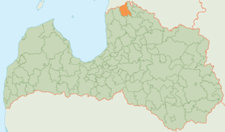
Ādaži Municipality is a municipality in the historical region of Vidzeme, and the Riga Planning Region in Latvia, which consists of Ādaži and Carnikava Parish plus the administrative centre, Ādaži. The municipality is located 25 km from the center of Riga.

Garkalne Municipality was a municipality in Vidzeme, Latvia. The municipality was formed in 2007 by reorganization of Garkalne Parish. The seat of the council of the municipality is situated extraterritorially in Berģi, Riga. The population in 2020 was 8,923.

Ropaži Municipality is a municipality in Vidzeme, Latvia. The municipality was formed in 2005 with the reorganization of Ropaži parish. The administrative centre is Ulbroka. The population in 2020 was 6,835.

Stopiņi Municipality is a former municipality in the historical region of Vidzeme, and the Riga Planning Region in Latvia. The municipality was formed in 2005 through the reorganization of Stopiņi Parish, the administrative centre being Ulbroka. The municipality consisted of the following villages and settlements: Ulbroka, Saurieši, Upeslejas, Dreiliņi, Vālodzes, Līči, Dzidriņas, Rumbula and Cekule. The population in 2020 was 11,458.

Aloja Municipality is a former municipality in Latvia. The municipality was formed in 2009 by merging Aloja town with its countryside territory, Staicele town with its countryside territory, Braslava Parish and Brīvzemnieki Parish, the administrative centre being Aloja. In 2010 Aloja Parish was created from the countryside territory of Aloja town and Staicele Parish was created from the countryside territory of Staicele town.

Beverīna Municipality is a former municipality in Vidzeme, Latvia. The municipality was formed in 2009 by merging Brenguļi Parish, Kauguri Parish and Trikāta Parish the administrative centre being Mūrmuiža.

Engure Municipality is a former Latvian municipality situated partly in the region of Courland and partly in Vidzeme. It bordered Mērsrags municipality, Tukums municipality, Jūrmala and the Gulf of Riga. The municipality was formed in 2009 by merging Engure parish, Smārde parish and Lapmežciems parish, with the administrative centre being Smārde. The population in 2020 was 7,124.

Krimulda Municipality is a former municipality in Vidzeme, Latvia. The municipality was formed in 2009 by merging Krimulda Parish and Lēdurga Parish, the administrative centre being Ragana.

Līgatne Municipality is a former municipality in Vidzeme, Latvia. The municipality was formed in 2009 by merging Līgatne parish and Līgatne town, with the administrative centre being Līgatne. It has an area of 167.7 km2 (64.7 sq mi).

Mālpils Municipality is a former municipality in Vidzeme, Latvia. The municipality was formed in 2009 by reorganization of Mālpils Parish. The administrative centre was Mālpils.
Mazsalaca Municipality is a former municipality in Vidzeme, Latvia. The municipality was formed in 2009 by merging Ramata parish, Sēļi parish, Skaņkalne parish and Mazsalaca town with its countryside territory, the administrative centre being Mazsalaca. In 2010 Mazsalaca parish was created from the countryside territory of Mazsalaca town.

Naukšēni Municipality is a former municipality in Vidzeme, Latvia. The municipality was formed in 2009 by merging Naukšēni Parish and Ķoņi Parish the administrative centre being Naukšēni. As of 2020, the population was 1,675.

Pārgauja Municipality is a former municipality in Vidzeme, Latvia. The municipality was formed in 2009 by merging Raiskums Parish, Stalbe Parish and Straupe Parish, the administrative centre being Stalbe. As of 2020, the population was 3,576.
Priekuļi Municipality is a former municipality in Vidzeme, Latvia. The municipality was formed in 2009 by merging Liepa Parish, Mārsnēni Parish, Priekuļi Parish and Veselava Parish, the administrative centre being Priekuļi. As of 2020, the population was 7,556.

Rūjiena Municipality is a former municipality in Vidzeme, Latvia. The municipality was formed in 2009 by merging Rūjiena town, Ipiķi parish, Jeri parish, Lode parish and Vilpulka parish, the administrative centre being Rūjiena. The population in 2020 was 4,824.

Saulkrasti Municipality is a municipality in Vidzeme, Latvia. The municipality was formed in 2009 by reorganization of Saulkrasti town with its countryside territory, with the administrative centre being Saulkrasti. In 2010 Saulkrasti parish was created from the countryside territory of Saulkrasti town. The population in 2020 was 6,735.

Kocēni Municipality is a former municipality in Vidzeme, Latvia. The municipality was formed in 2009 by merging Bērzaine Parish, Dikļi Parish, Kocēni Parish, Vaidava Parish and Zilākalns Parish; the administrative centre being Kocēni. Until 28 January 2010 the name of municipality was Valmiera Municipality.

Carnikava, previously Sānkaule, is a village and the center of Carnikava Parish in Ādaži Municipality, Latvia. It's located 25 km north from Riga at the mouth of the Gauja River. Carnikava had 4689 residents as of January 2020, making it the largest village by population in Latvia.
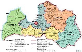
Pierīga Region is one of the six statistical regions of Latvia.