
Lancashire is a ceremonial county in North West England. It is bordered by Cumbria to the north, North Yorkshire and West Yorkshire to the east, Greater Manchester and Merseyside to the south, and the Irish Sea to the west. The largest settlement is Blackpool, and the county town is the city of Lancaster, with the administrative centre being Preston.
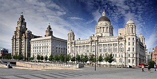
Merseyside is a ceremonial and metropolitan county in North West England. It borders Lancashire to the north, Greater Manchester to the east, Cheshire to the south, the Welsh county of Flintshire across the Dee Estuary to the southwest, and the Irish Sea to the west. The largest settlement is the city of Liverpool.
Southport is a seaside town in the Metropolitan Borough of Sefton in Merseyside, England. At the 2021 census, it had a population of 94,421, making it the eleventh most populous settlement in North West England.
Newton-le-Willows is a market town in the Metropolitan Borough of St Helens, Merseyside, England. The population at the 2021 census was 24,642. Newton-le-Willows is on the eastern edge of St Helens, south of Wigan and north of Warrington.

Ashton-in-Makerfield is a market town in the Metropolitan Borough of Wigan, Greater Manchester, England, 4 miles (6.4 km) south of Wigan. As of the 2021 census, there was a population of 26,380.

Kirkham aka Kirkam-in-Amounderness is a market town and civil parish in the Borough of Fylde in Lancashire, England, midway between Blackpool and Preston and adjacent to the town of Wesham. It owes its existence to Carr Hill upon which it was built and which was the location of a Roman fort. At the census of 2011, it had a population 3,304 plus 3,890, giving a total of 7,194. By the census of 2021 the total had risen to 3,217 plus 4,666, giving a total of 7,883.
The Metropolitan Borough of St Helens is a local government district with borough status in Merseyside, North West England. The borough is named after its largest settlement, St Helens, but also includes neighbouring towns and villages such as Earlestown, Rainhill, Eccleston, Clock Face, Haydock, Billinge, Garswood, Rainford and Newton-le-Willows.
Nelson is a town and civil parish in the Borough of Pendle in Lancashire, England, with a population of 29,135 in 2011. Nelson is 2.66 miles (4 km) north of Burnley and 1.77 miles (3 km) south-west of Colne. Nelson developed as a mill town during the Industrial Revolution, but has today lost much of its industry and is characterised by some of the lowest house prices in the United Kingdom.

Haydock is a village within the Metropolitan Borough of St Helens, in Merseyside, England. At the 2011 Census, it had a population of 11,416 Haydock's historic area covers the Haydock electoral ward and a section of the Blackbrook ward.

Whiston is a town and civil parish within the Metropolitan Borough of Knowsley in Merseyside, England. Previously recorded within the historic county of Lancashire, it is located eight miles east of Liverpool. The population was 13,629 at the 2001 Census, increasing to 14,263 at the 2011 Census.

St Helens is a town in Merseyside, England, with a population of 102,629. It is the administrative centre of the Metropolitan Borough of St Helens, which had a population of 183,200 at the 2021 Census.

Eccleston is a civil parish in the Metropolitan Borough of St Helens, Merseyside, England. At the 2011 census, it had a population of 10,433.

Billinge is a village within the Metropolitan Borough of St Helens, Merseyside, England. It forms the larger part of the civil parish of Billinge Chapel End.

Bold is a civil parish in the Metropolitan Borough of St Helens in Merseyside, England. Bold itself is situated to the south east of St Helens, near to the boundaries with Halton and Warrington. The parish extends southwards beyond the M62 motorway and includes the hamlet of Bold Heath along with the Clock Face and New Bold area of St Helens. According to the 2001 Census it had a population of 3,410 at the 2011 Census
Sutton is an area of St Helens, Merseyside, and Ward of the metropolitan borough of the same name. The population of the ward taken at the 2011 census was 12,003.

The Lancashire County Rugby Football Union is the society responsible for rugby union in the county of Lancashire, England, and is one of the constituent bodies of the national Rugby Football Union having been formed in 1881. In addition it is the county that has won the County Championship on most occasions
Hoghton Road Stadium was a sports stadium on Hoghton Road, Sutton, a suburb of St. Helens, the administrative centre of the Metropolitan Borough of St Helens in Merseyside, England.
Rugby League in Lancashire refers to the sport of rugby league in relation to its participation and history within the traditional county of Lancashire, England. The county has since been split up for administrative purposes with parts of traditional Lancashire forming parts of Greater Manchester, Merseyside, Cheshire and Cumbria as well as the current borders of Lancashire.
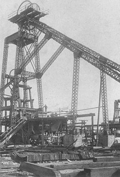
St Helens Greyhound Racing and Sports Stadium was a greyhound racing and former football stadium off Park Road in Parr, St Helens, Lancashire


