 Animated map of the extent of the glaciers of the Carstens Range from 1850 to 2003
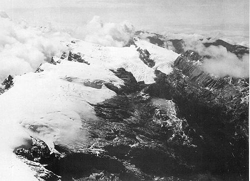 Puncak Jaya region icecap in 1936.
 Puncak Jaya glaciers in 1972. Left to right: West Northwall Firn, East Northwall Firn, Meren Glacier (now disappeared), and Carstensz Glacier. See also animation.
| Carstensz Glacier | |
|---|---|
 The Carstensz Glacier is at lower right in this 2005 image. The circular depression to the left is the Grasberg mine, the world's largest gold mine. | |
 Carstensz Glacier  Carstensz Glacier | |
| Type | Mountain glacier |
| Location | Puncak Jaya, Sudirman Range, Central Papua, Indonesia |
| Coordinates | 04°04′59.32″S137°10′44.77″E / 4.0831444°S 137.1791028°E |
| Area | 0.05 km2 (0.019 sq mi) in November 2023 |
| Length | 470 m (1,540 ft) |
| Terminus | Rockfall |
| Status | Retreating |
 | |
The Carstensz Glacier is near the peak of Puncak Jaya (sometimes called Mount Carstensz or the Carstensz Pyramid) which is a mountain in the Sudirman Range of the island of New Guinea, territorially the eastern highlands of Central Papua, Indonesia. The glacier is situated at an elevation of approximately 4,660 metres (15,290 ft) and is 1.5 kilometres (0.93 mi) east of the summit tower of Puncak Jaya. In 2002 the Carstensz Glacier was 1.4 kilometres (0.87 mi) in length and .60 kilometres (0.37 mi) wide. In November 2023 it was only 470 metres (1,540 ft) long and 100 metres (330 ft) wide.
Contents
The glacier is named after the 17th century Dutch explorer Jan Carstenszoon, commonly known as Jan Carstensz.


