
A geographic information system (GIS) is a conceptualized framework that provides the ability to capture and analyze spatial and geographic data. GIS applications are computer-based tools that allow the user to create interactive queries, store and edit spatial and non-spatial data, analyze spatial information output, and visually share the results of these operations by presenting them as maps.
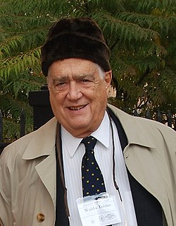
Waldo Rudolph Tobler was an American-Swiss geographer and cartographer. Tobler's idea that "Everything is related to everything else, but near things are more related than distant things" is referred to as the "first law of geography." He has proposed a second law as well: "The phenomenon external to an area of interest affects what goes on inside". Tobler was an active Professor Emeritus at the University of California, Santa Barbara Department of Geography until his death.
Geoinformatics is the science and the technology which develops and uses information science infrastructure to address the problems of geography, cartography, geosciences and related branches of science and engineering.
The American Congress on Surveying and Mapping (ACSM) was an American professional association representing the interests of those engaged in measuring and communicating geospatial data.
Geographic information science or geographical information science is the scientific discipline that studies the techniques to capture, represent, process, and analyze geographic information. It can be contrasted with geographic information systems (GIS), which are software tools.
Participatory GIS (PGIS) or public participation geographic information system (PPGIS) is a participatory approach to spatial planning and spatial information and communications management.

The International Cartographic Association (ICA), is an organization formed of national member organizations, to provide a forum for issues and techniques in cartography and geographic information science (GIScience). ICA was founded on June 9, 1959, in Bern, Switzerland. The first General Assembly was held in Paris in 1961. The mission of the International Cartographic Association is to promote the disciplines and professions of cartography and GIScience in an international context. To achieve these aims, the ICA works with national and international governmental and commercial bodies, and with other international scientific societies.

A Web mapping or an online mapping is the process of using the maps delivered by geographic information systems (GIS) on the Internet, more specifically in the World Wide Web (WWW). A web map or an online map is both served and consumed, thus web mapping is more than just web cartography, it is a service by which consumers may choose what the map will show. Web GIS emphasizes geodata processing aspects more involved with design aspects such as data acquisition and server software architecture such as data storage and algorithms, than it does the end-user reports themselves.
A historical geographic information system is a geographic information system that may display, store and analyze data of past geographies and track changes in time. It can be regarded as a subfield of historical geography and geographic information science.
The American Society for Photogrammetry and Remote Sensing (ASPRS) is an American learned society devoted to photogrammetry and remote sensing. It is the United States' member organization of the International Society for Photogrammetry and Remote Sensing. Founded in 1934 as American Society of Photogrammetry and renamed in 1985, the ASPRS is a scientific association serving over 7,000 professional members around the world. As a professional body with oversight of specialists in the arts of imagery exploitation and photographic cartography. Its official journal is Photogrammetric Engineering & Remote Sensing (PE&RS), known as Photogrammetric Engineering between 1937 and 1975.
Critical cartography is a set of mapping practices and methods of analysis grounded in critical theory, specifically the thesis that maps reflect and perpetuate relations of power, typically in favor of a society's dominant group. Critical cartographers aim to reveal the “‘hidden agendas of cartography’ as tools of socio-spatial power”. While the term "critical cartography" often refers to a body of theoretical literature, critical cartographers also call for practical applications of critical cartographic theory, such as counter-mapping, participatory mapping, and neogeography.
The British Cartographic Society (BCS) is an association of individuals and organisations dedicated to exploring and developing the world of maps. It is a registered charity. Membership includes mapping companies, publishers, designers, academics, researchers, map curators, individual cartographers, GIS specialists and ordinary members of the public with an interest in maps.

Geography is a field of science devoted to the study of the lands, features, inhabitants, and phenomena of the Earth and planets. The first person to use the word γεωγραφία was Eratosthenes. Geography is an all-encompassing discipline that seeks an understanding of Earth and its human and natural complexities—not merely where objects are, but also how they have changed and come to be.
The Urban and Regional Information Systems Association (URISA) is a non-profit association of professionals using geographic information systems (GIS) and other information technologies to solve challenges at all levels of government. URISA promotes the effective and ethical use of spatial information and technology for the understanding and management of urban and regional systems.

CARTO is a Software as a Service (SaaS) cloud computing platform that provides GIS, web mapping, and spatial data science tools. The company is positioned as a Location Intelligence platform due to tools with an aptitude for data analysis and visualization that do not require previous GIS or development experience.

The Cartographic Journal, is an established peer-reviewed academic journal of record and comment that is published on behalf of the British Cartographic Society by Taylor & Francis. An official journal of the International Cartographic Association (ICA), it contains authoritative papers on all aspects of cartography: the art, science and technology of presenting, communicating and analysing spatial relationships by means of maps and other geographical representations of the Earth's surface. This includes coverage of related technologies where appropriate, for example, remote sensing and geographical information systems (GIS), the internet, satellite navigation and positioning systems, laser scanning, and terrain modelling. The Journal also publishes articles on social, political and historical aspects of cartography. Occasionally, Special Issues are published that focus on a particular research theme.
Cartography and Geographic Information Science is an academic journal about cartography and geographic information science published by Taylor & Francis on behalf of the U.S. Cartography and Geographic Information Society, in affiliation with the International Cartographic Association. Its editor-in-chief is Alexander Ken; its 2018 impact factor is 2.271.

Ed Parsons is a London-based Geospatial Technologist and tech evangelist at Google. He is working to evangelise geospatial data for commercial application and consequently, to improve the usability and efficiency of location based tools at Google. He is credited as being one of the core proponents of Google Street View.

Keith Charles Clarke is a Professor of Analytical Cartography and Modelling in the Department of Geography at the University of California, Santa Barbara, USA.