
Cartography is the study and practice of making and using maps. Combining science, aesthetics and technique, cartography builds on the premise that reality can be modeled in ways that communicate spatial information effectively.

The Renaissance is a period of history and a European cultural movement covering the 15th and 16th centuries. It marked the transition from the Middle Ages to modernity and was characterized by an effort to revive and surpass the ideas and achievements of classical antiquity. Associated with great social change in most fields and disciplines, including art, architecture, politics, literature, exploration and science, the Renaissance was first centered in the Republic of Florence, then spread to the rest of Italy and later throughout Europe. The term rinascita ("rebirth") first appeared in Lives of the Artists by Giorgio Vasari, while the corresponding French word renaissance was adopted into English as the term for this period during the 1830s.

Furniture refers to objects intended to support various human activities such as seating, eating (tables), storing items, working, and sleeping. Furniture is also used to hold objects at a convenient height for work, or to store things. Furniture can be a product of design and can be considered a form of decorative art. In addition to furniture's functional role, it can serve a symbolic or religious purpose. It can be made from a vast multitude of materials, including metal, plastic, and wood. Furniture can be made using a variety of woodworking joints which often reflects the local culture.

Gerardus Mercator was a Flemish geographer, cosmographer and cartographer. He is most renowned for creating the 1569 world map based on a new projection which represented sailing courses of constant bearing as straight lines—an innovation that is still employed in nautical charts.
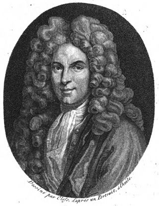
Guillaume Delisle, also spelled Guillaume de l'Isle, or Guillelmo Delille was a French cartographer known for his popular and accurate maps of Europe and the newly explored Americas.

A brooch is a decorative jewellery item designed to be attached to garments, often to fasten them together. It is usually made of metal, often silver or gold or some other material. Brooches are frequently decorated with enamel or with gemstones and may be solely for ornament or serve a practical function as a clothes fastener. The earliest known brooches are from the Bronze Age. As fashions in brooches changed rather quickly, they are important chronological indicators. In archaeology, ancient European brooches are usually referred to by the Latin term fibula.

A mappa mundi is any medieval European map of the world. Such maps range in size and complexity from simple schematic maps 25 millimetres or less across to elaborate wall maps, the largest of which to survive to modern times, the Ebstorf map, was around 3.5 m in diameter. The term derives from the Medieval Latin words mappa and mundus (world).

A world map is a map of most or all of the surface of Earth. World maps, because of their scale, must deal with the problem of projection. Maps rendered in two dimensions by necessity distort the display of the three-dimensional surface of the Earth. While this is true of any map, these distortions reach extremes in a world map. Many techniques have been developed to present world maps that address diverse technical and aesthetic goals.

The earliest known term used for maps in Japan is believed to be kata, which was probably in use until roughly the 8th century. During the Nara period, the term zu (図) came into use, but the term most widely used and associated with maps in pre-modern Japan is ezu. As the term implies, ezu were not necessarily geographically accurate depictions of physical landscape, as is generally associated with maps in modern times, but pictorial images, often including spiritual landscape in addition to physical geography. Ezu often focused on the conveyance of relative information as opposed to adherence to visible contour. For example, an ezu of a temple may include surrounding scenery and clouds to give an impression of nature, human figures to give a sense of how the depicted space is used, and a scale in which more important buildings may appear bigger than less important ones, regardless of actual physical size.

Portolan charts are nautical charts, first made in the 13th century in the Mediterranean basin and later expanded to include other regions. The word portolan comes from the Italian portolano, meaning "related to ports or harbors", and which since at least the 17th century designates "a collection of sailing directions".

An Ex Libris from ex-librīs, also known as a bookplate, is a printed or decorative label pasted into a book, often on the front endpaper, to indicate ownership. Simple typographical bookplates are termed "book labels".

The history of cartography refers to the development and consequences of cartography, or mapmaking technology, throughout human history. Maps have been one of the most important human inventions for millennia, allowing humans to explain and navigate their way through the world.

A justacorps or justaucorps is a knee-length coat worn by men in the latter half of the 17th century and throughout the 18th century. It is of French origin, where it had developed from a cape-like garment called a casaque. It was introduced into England as a component of a three-piece ensemble, which also included breeches and a long vest or waistcoat. This ensemble served as the prototype for the modern-day three-piece suit. The justacorps itself evolved into the frock coat.

A cartouche is an oval or oblong design with a slightly convex surface, typically edged with ornamental scrollwork. It is used to hold a painted or low-relief design. Since the early 16th century, the cartouche is a scrolling frame device, derived originally from Italian cartuccia. Such cartouches are characteristically stretched, pierced and scrolling.
The cartography of India begins with early charts for navigation and constructional plans for buildings. Indian traditions influenced Tibetan and Islamic traditions, and in turn, were influenced by the British cartographers who solidified modern concepts into India's map making.

In architecture and the decorative arts, a mascaron ornament is a face, usually human, sometimes frightening or chimeric, whose alleged function was originally to frighten away evil spirits so that they would not enter the building. The concept was subsequently adapted to become a purely decorative element. The most recent architectural styles to extensively employ mascarons were Beaux Arts and Art Nouveau. In addition to architecture, mascarons are used in the other applied arts.
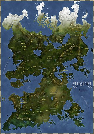
Fantasy cartography, fictional map-making, or geofiction is a type of map design that visually presents an imaginary world or concept, or represents a real-world geography in a fantastic style. Fantasy cartography usually manifests from worldbuilding and often corresponds to narratives within the fantasy and science fiction genres. Stefan Ekman says, "a [regular] map re-presents what is already there; a fictional map is often primary – to create the map means, largely, to create the world of the map."

Islamic influences on Western art refers to the stylistic and formal influence of Islamic art, defined as the artistic production of the territories ruled by Muslims from the 7th century onward, on European Christian art. Western European Christians interacted with Muslims in Europe, Africa, and the Middle East and formed a relationship based on shared ideas and artistic methods. Islamic art includes a wide variety of media including calligraphy, illustrated manuscripts, textiles, ceramics, metalwork, and glass, and because the Islamic world encompassed people of diverse religious backgrounds, artists and craftsmen were not always Muslim, and came from a wide variety of different backgrounds. Glass production, for example, remained a Jewish speciality throughout the period. Christian art in Islamic lands, such as that produced in Coptic Egypt or by Armenian communities in Iran, continued to develop under Islamic rulers.
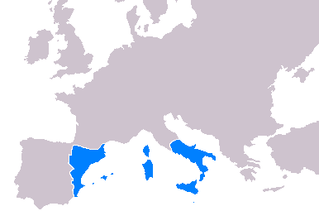
Cartography throughout the 14th-16th centuries played a significant role in the expansion of the kingdoms of the Iberian Peninsula for a multitude of reasons. Primarily, the maps developed during this period served as navigational tools for maritime folk such as explorers, sailors and navigators. Mostly the expansion of the Crown of Aragon (which included the Kingdom of Aragon, Kingdom of Valencia and Kingdom of Majorca, together with the Principality of Catalonia, all its territories with seashore on the Mediterranean Sea. The Crown of Aragon controlled the routes across the Mediterranean Sea from the Kingdom of Jerusalem to Europe, as part of the commercial-trade route known as the Silk Road.

J. R. R. Tolkien's maps, depicting his fictional Middle-earth and other places in his legendarium, helped him with plot development, guided the reader through his often complex stories, and contributed to the impression of depth and worldbuilding in his writings.

