Related Research Articles
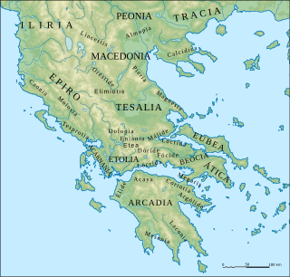
The Molossians were a group of ancient Greek tribes which inhabited the region of Epirus in classical antiquity. Together with the Chaonians and the Thesprotians, they formed the main tribal groupings of the northwestern Greek group. On their northern frontier, they neighbored the Chaonians and on their southern frontier neighbored the kingdom of the Thesprotians. They formed their own state around 370 BC and were part of the League of Epirus. The most famous Molossian ruler was Pyrrhus of Epirus, considered one of the greatest generals of antiquity. The Molossians sided against Rome in the Third Macedonian War and were defeated. Following the war, the region witnessed devastation while a considerable number of Molossians and other Epirotes were enslaved and transported to the Roman Republic, overwhelmingly in the Italian Peninsula itself.
The Chaonians were an ancient Greek people that inhabited the historical region of Epirus which today is part of northwestern Greece and southern Albania. Together with the Molossians and the Thesprotians, they formed the main tribes of the northwestern Greek group. In historical times on their southern frontier lay the Epirote kingdom of the Molossians, to their southwest stood the kingdom of the Thesprotians, and to their north the Illyrians. By the 5th century BC, they had conquered and combined to a large degree with the neighboring Thesprotians and Molossians. The Chaonians were part of the Epirote League until 170 BC when their territory was annexed by the Roman Republic.

Elaias Limen, also Elaea or Elaia (Ἐλαία), was a harbour town of Thesprotia in ancient Epirus at the mouth of the Acheron river. The town is mentioned by both Scylax and Ptolemy. The Periplus of Pseudo-Scylax asserts that this was the main port of Thesprotia. The town's site is identified as near Cheimerion.

Amantia was an ancient city and the main settlement of the Amantes, traditionally located in southern Illyria in classical antiquity. In Hellenistic times the city was either part of Illyria or Epirus. In Roman times it was included within Epirus Nova, in the province of Macedonia. The site has been identified with the village of Ploçë, Vlorë County, Albania. Amantia was designated as an archaeological park on 7 April 2003 by the government of Albania.

Oricum was a harbor on the Illyrian coast that developed in an Ancient Greek polis at the south end of the Bay of Vlorë on the southern Adriatic coast. It was located at the foot of the Akrokeraunian Mountains, the natural border between ancient Epirus and Illyria. Oricum later became an important Roman city between the provinces of Epirus Vetus and Epirus Nova in Macedonia. It is now an archaeological park of Albania, near modern Orikum, Vlorë County. Oricum holds such a strategic geographical position that the area has been in continuous usage as a naval base from antiquity to the present-days.
Alorus or Aloros was a town of ancient Macedonia in the district Bottiaea, placed by Stephanus of Byzantium in the innermost recess of the Thermaic Gulf. According to the Periplus of Pseudo-Scylax it was situated between the Haliacmon and Lydias. The town is chiefly known on account of its being the birthplace of Ptolemy, who usurped the Macedonian throne after the murder of Alexander II of Macedon, son of Amyntas, and who is usually called Ptolemaeus Alorites. It was also the birthplace of Pantauchus, the general of Alexander the Great.

Epirus was an ancient Greek kingdom, and later republic, located in the geographical region of Epirus, in parts of north-western Greece and southern Albania. Home to the ancient Epirotes, the state was bordered by the Aetolian League to the south, Ancient Thessaly and Ancient Macedonia to the east, and Illyrian tribes to the north. The Greek king Pyrrhus is known to have made Epirus a powerful state in the Greek realm that was comparable to the likes of Ancient Macedonia and Ancient Rome. Pyrrhus' armies also attempted an assault against the state of Ancient Rome during their unsuccessful campaign in what is now modern-day Italy.

Phagres was a Greek city located in ancient Thrace and later in Macedon, in the region between the river Strymon and the river Nestos called Edonis or Pieris. It was founded by colonists from Thasos. It was perhaps together with Galepsus and Apollonia occupied and destroyed by Philip II of Macedon after the capture of Amphipolis. Despite this, archeological remains include Hellenistic finds and indications that Phagres survived into the Roman period.
Atintanes or Atintanians was an ancient tribe that dwelled in the borderlands between Epirus and Illyria, in an inland region which was called Atintania. They have been described as either an Epirote tribe that belonged to the northwestern Greek group, or as an Illyrian tribe. They were occasionally subordinate to the Molossians.

Parauaea was an ancient Greek territory in the region of Epirus. The inhabitants of the area, a Thesprotian Greek tribe, were known as Parauaioi, which meant "those dwelling beside" the Aous river.
Demetrium or Demetrion, was a town of Phthiotis in ancient Thessaly, whose name derived from a temple of Demeter near Pyrasus spoken of by Homer in the Iliad, and which Strabo describes as the successor settlement to, and two stadia distant from Pyrasus. Besides Strabo, Demetrium is mentioned by numerous ancient authors: in the Periplus of Pseudo-Scylax, by Livy, Pomponius Mela, and Stephanus of Byzantium.
Elaea or Elaia, also Elea (Ἐλέα), was a town of Thesprotia in ancient Epirus toward the mouth of the Acheron river. The town is mentioned by Ptolemy. Thucydides calls the surrounding district Elaeatis (Ἐλαιατις) and indicates that Ephyra was in the territory of Elaea. Its port was Elaias Limen, literally the "Bay of Elaea", which the Periplus of Pseudo-Scylax asserts was the main port of Thesprotia.

Siphae or Siphai, also known as Tipha (Τίφα), was a town of ancient Boeotia, upon the Corinthian Gulf, which was said to have derived its name from Tiphys, the pilot of the Argonauts. In the time of Pausanias the inhabitants of Siphae pointed out the spot where the ship Argo anchored on its return from its celebrated voyage. The same writer mentions a temple of Heracles at Siphae, in whose honour an annual festival was celebrated. Apollonius Rhodius and Stephanus of Byzantium describe Siphae as a dependency of Thespiae.
Charadrus or Charadrous was an ancient Greek city of the Acte headland of Chalcidice noted in the Periplus of Pseudo-Scylax The name has also come down to us in the form Charadriae (Χαραδρίαι).
Siderus was a port town of ancient Lycia, referenced in the Periplus of Pseudo-Scylax and the Stadiasmus Maris Magni. The town is also noted by Stephanus of Byzantium under the name Sidarus or Sidarous (Σιδαροῦς). The place may also have borne the name Posidarisus or Posidarisous, mentioned in The Chronicon of Hippolytus as being 30 stadia from Crambousa and the same distance from Moron Hydor.
Carambis or Karambis was an ancient Greek city of ancient Paphlagonia, on a promontory of the same name. The town is mentioned in the Periplus of Pseudo-Scylax and by Pliny the Elder. The name occurs as Carambas in the Peutinger Table.
Stephane was a small port town on the coast of ancient Paphlagonia, according to Arrian 180 stadia east of Cimolis, but according to Marcian of Heraclea only 150. The place was mentioned as early as the time of Hecataeus of Miletus as a town of the Mariandyni, under the name of Stephanis (Στεφανίς). The town is also mentioned in the Periplus of Pseudo-Scylax and by the geographer Ptolemy. The name is written Stefano in the Peutinger Table.
Placia or Plakia or Placie or Plakie, also known as Placa or Plaka or Place or Plake (Πλάκη), was a town of ancient Mysia, on the coast of the Propontis, at the foot of the Mysian Olympus east of Cyzicus. It was a Pelasgian town; in this place and the neighbouring Scylace, the Pelasgians, according to Herodotus, had preserved their ancient language down to his time. The town is mentioned in the Periplus of Pseudo-Scylax, and by Pomponius Mela, Dionysius of Halicarnassus and Pliny the Elder.
Callichorus or Kallichoros, also called Oxines or Oxinas, was a river of ancient Bithynia. It is mentioned by Pliny the Elder and also by the author of the Periplus of Pseudo-Scylax under the name Callichorus. Under the name Oxinas, it is mentioned by Arrian as draining into the Pontus Euxinus between Heraclea Pontica and Phyllium. Called Oxines by Marcianus, who places its mouth 90 stadia northeast of Cape Posidium.
Hypius or Hypios, also Hyppius or Hyppios (Ὕππιος), was a river of ancient Bithynia, not far westward from the Sangarius River. The river itself is very small; but at its mouth it is so broad that the greater part of the fleet of Mithridates was enabled to take up its winter quarters in it. According to the Periplus of Pseudo-Scylax, this river formed the boundary between the territories of the Bithyni and the Mariandyni.
References
- ↑ Hatzopoulos 2007 , "Since only Hellenes participated in the Panhellenic sacrifices and contests, it is obvious that the theoroi visited only communities which considered themselves and were considered by the others as Greek. [...] Similarly the [theorodokoi] section Epirus lists the states of Pandosia, Kassopa, Thesprotoi, Poionos, Korkyra, Chaonia, Artichia, Molossoi, Ambrakia, Argos (of Amphilochia). Of these the Elean colony of Pandosia and the Corinthian colonies of Korkyra and Ambrakia represent the southern Greek element, while Kassopa, the Thesprotoi, the Molossoi, Chaonia and Argos the "native" Epirote one. (Nothing is known of Poionos and Artichia). The important point is that colonial cities, Epirote cities and Epirote ethne, republican and monarchical alike, are considered equally Greek and invited to the great panhellenic sacrifices at Epidauros."
- ↑ Strabo. Geographica . Vol. vii. p.324, et seq. Page numbers refer to those of Isaac Casaubon 's edition.
- ↑
 Smith, William, ed. (1854–1857). "Cassope". Dictionary of Greek and Roman Geography . London: John Murray.
 - ↑ Stephanus of Byzantium. Ethnica. Vol. s.v. Κασσωπία πόλις.
- ↑ Periplus of Pseudo-Scylax , p. 12
- ↑ Demosthenes, On Halonnesus 33.
- ↑ Theopompus ap. Harpocr. s.v. Ἐλάτεια
![]() This article incorporates text from a publication now in the public domain : Smith, William, ed. (1854–1857). "Cassope". Dictionary of Greek and Roman Geography . London: John Murray.
This article incorporates text from a publication now in the public domain : Smith, William, ed. (1854–1857). "Cassope". Dictionary of Greek and Roman Geography . London: John Murray.
Sources
- Hatzopoulos, Miltiades B. (2007) [2002]. "Perception of the Self and the Other: The Case of Macedonia". Ancient Macedonia VII: Macedonia from the Iron Age to the Death of Philip II. Papers Read at the Seventh International Symposium Held in Thessaloniki, October 14–18, 2002. Thessaloniki: Institute for Balkan Studies. pp. 51–66. ISBN 978-9-6073874-2-4.
| | This Ancient Greece related article is a stub. You can help Wikipedia by expanding it. |