
Peel is a seaside town and small fishing port in the Isle of Man, in the historic parish of German but administered separately. Peel is the third largest town in the Island after Douglas and Ramsey but the fourth largest settlement, as Onchan has the second largest population but is classified as a village.

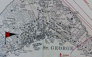
St. George's, located on the island and within the parish of the same names, settled in 1612, is the first permanent English settlement on the islands of Bermuda. It is often described as the third permanent British settlement in the Americas, after Jamestown, Virginia (1607), and Cupids, Newfoundland (1610), and the oldest continuously-inhabited British town in the New World, since the other two settlements were seasonal for a number of years.

Kindley Air Force Base was a United States Air Force base in Bermuda from 1948–1970, having been operated from 1943 to 1948 by the United States Army Air Forces as Kindley Field.

Devonshire Parish is one of the nine parishes of Bermuda. Originally named Cavendish Tribe and later Devonshire Tribe, for William Cavendish, 1st Earl of Devonshire (1552–1626). Devonshire Redoubt, on Castle Island, one of the Castle Harbour fortifications of St. George's Parish, was also named after him.
St. George's Parish is one of the nine parishes of Bermuda. It is named after the founder of the Bermuda colony, Admiral Sir George Somers.

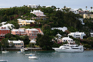
Hamilton Harbour is a natural harbour in Bermuda which serves as the port for the capital, the City of Hamilton. It is an arm of the Great Sound, and forms a tapering wedge shape of water between Paget Parish and the peninsula which forms Pembroke Parish, and upon which the capital sits.
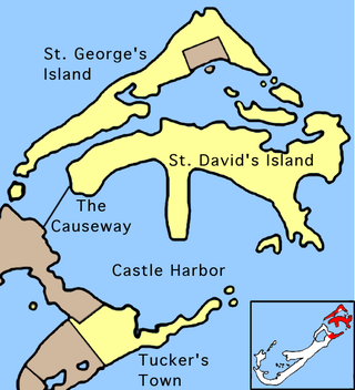
The Causeway is a narrow strip of reclaimed land and bridges in the north of Bermuda linking Hamilton Parish on the mainland in the southwest and Bermuda International Airport on St. David's Island in St. George's Parish in the northeast, which are otherwise divided by Castle Harbour.

Castle Harbour is a large natural harbour in Bermuda. It is located between the northeastern end of the main island and St. David's Island. Originally called Southampton Port, it was renamed as a result of its heavy fortification in the early decades of the Seventeenth century.

Castle Island is part of the chain which makes up Bermuda. It is located in St. George's Parish, in the northeast of the territory.
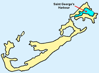
St. George's Harbour is a natural harbour in the north of Bermuda. It serves as the port for the town of St. George's, located on St. George's Island, to its north. To its south is St. David's Island. The harbour and both islands lie within St. George's Parish. It was for two centuries the primary harbour of the British Overseas Territory.

Ferry Reach is a three mile long channel in the north-east of Bermuda, which lies between St. George's Island in the north and St. David's Island in the south, south-west of the town of St. George's.
St. David's Island is one of the main islands of the British Overseas Territory of Bermuda. It is located in the far north of the territory, one of the two similarly sized islands that make up the majority of St. George's Parish.
The architecture of Bermuda has developed over the past four centuries. The archipelago's isolation, environment, climate, and scarce resources have been key driving points, though inspiration from Europe, the Caribbean and the Americas is evident. Distinctive elements appeared with initial settlement in the early 17th century, and by the second half of that century features that remain common today began to appear.

Several of the islands strung across the South entrance of Castle Harbour, Bermuda were fortified in the early days of the territory, hence the harbour's name. When official settlement of the archipelago by England began in 1612 the first permanent town, St. George's was placed on the North side of St. George's Harbour. St. George's Harbour could be accessed directly by channels from the East. Those channels, however, were shallow, suitable, originally, only for small ships. As a consequence, and despite any major settlement on its shores, Castle Harbour was an important anchorage in the early years of the colony, with its main entrance, Castle Roads being an important route in from the open Atlantic for shipping. It was also a weak point, as it was remote from the defences of St. George's Harbour, and difficult to reach. It was quickly fortified and garrisoned by a standing militia.

Fort St. Catherine, or Fort St. Catherine's, is a coastal artillery fort at the North-East tip of St. George's Island, in the Imperial fortress colony of Bermuda. Successively redeveloped, the fort was used first by Bermudian Militia and then by regular Royal Artillery units from 1612 into the 20th century. Today it houses a museum.
The Historic Town of St George and Related Fortifications is the name used by the United Nations Educational, Scientific and Cultural Organization's (UNESCO) World Heritage Committee to identify collectively as a World Heritage Site St. George's Town, founded in 1612, and a range of fortifications, batteries, and magazines built between 1612 and 1939, the last of which was removed from use in 1953.
The Western Redoubt, or Fort William, is a square fort built on a crest on the eastern side of Government Hill, and within the boundaries of the original main British Army camp in the Imperial fortress colony of Bermuda, St. George's Garrison.

Fort Victoria is a disused British Army fort, built to house coastal artillery atop Retreat Hill, within St. George's Garrison, at the North-East of St. George's Island, in the British colony of Bermuda.

Scaur Hill Fort, also called Scaur Hill Lines and Somerset Lines, is a fortified position erected in the 1870s at Scaur Hill, on Somerset Island, in Sandys Parish, the westernmost parish of the Imperial fortress colony of Bermuda.
Fort George is a square fort built on the crest of Mount Hill to the west of St. George's Town, near to, but outside of the boundaries of the original main British Army camp in the Imperial fortress colony of Bermuda, St. George's Garrison.


