Castle Islands Fortifications, Bermuda

Last updated

Castle Islands Fortifications, Bermuda
John Smith 1624 map of Bermuda with Forts 01.jpg
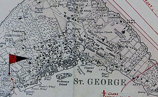
Captain John Smith's 1624 map of Bermuda, showing contemporary fortifications
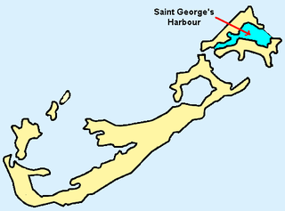
Location Castle Harbour, Bermuda
Built17th Century
TypeCultural
Criteriaiv
Designated2000 (24th session)
Part of Historic Town of St George and Related Fortifications, Bermuda
Reference no. 983
Region Europe and North America

Several of the islands strung across the South entrance of Castle Harbour, Bermuda were fortified in the early days of the territory, hence the harbour's name. When official settlement of the archipelago by England began in 1612 (unofficial settlement having begun with the 1609 wrecking of the Sea Venture) the first permanent town, St. George's (then called New London) was placed on the North side of St. George's Harbour. St. George's Harbour could be accessed directly by channels from the East. Those channels, however, were shallow, suitable, originally, only for small ships. As a consequence, and despite any major settlement on its shores, Castle Harbour was an important anchorage in the early years of the colony, with its main entrance, Castle Roads being an important route in from the open Atlantic for shipping. It was also a weak point, as it was remote from the defences of St. George's Harbour, and difficult to reach. It was quickly fortified and garrisoned by a standing militia. [1] [2]

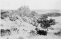
Initial fortification by the Virginia Company's (Bermuda was originally settled as an extension of Virginia) first deliberate settlers in 1612, was around the inlets to St. George's Harbour, but by the end of that year work had commenced on Castle Harbour's defences, starting at Castle Island (previously called Gurnett's Head, and King's Island). As a temporary measure, two guns had been salvaged from the 1609 wreck of the Sea Venture, one of which was installed on Castle Island ) in 1612. Proper fortifications were soon raised under the instructions of Governor Richard Moore. King's Castle (called Queen's Castle during the reigns of Queen Anne and Queen Victoria, though, like King's Square in St. George's Town, current practice ignores the sex of the current Monarch) is, today, the oldest surviving English fortification in the New World. It is Bermuda's oldest standing stone building, predating the State House. Its Captain's House, built a year after the State House, in 1621, is the oldest stone home in Bermuda. It is also the oldest standing English house in the New World. In 1614, King's Castle famously repulsed Spain's only ever attack on Bermuda. Two shots were fired from its artillery. Although neither struck, the Spanish vessel abandoned the attack (its crew did not realise that the gunners in the fort had only enough ammunition for one more shot). This fort was used as late as the Second World War by Bermuda's military garrison, with soldiers living in tents within its walls, watching over the channels with machine guns. Other forts built at the South of Castle Harbour included Devonshire Redoubt (1620) and the Landward Fort, on Castle Island, Southampton Fort (1620), on Brangman's Island (originally known as Moore's Island and Southampton Island), at the East side of Castle Roads, Old Castle, or Charles' Fort, (1615), on Goat Island, Pembroke Fort, on Cooper's Island, and Fort Bruere, on the Main Island. [3]

Forts and batteries on the islands of St. George's Harbour (1-13) and Castle Harbour (14-25), Bermuda

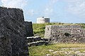
At Ferry Reach, on the north of Castle Harbour (an area now separated by the Causeway), Burnt Point Fort, or Ferry Point Battery (in 1688), and Ferry Island Fort (in the 1790s) were built, [4] and in 1822 a Martello Tower. Ferry Island Fort and the Martello tower were both built by the regular British Army, which had established a permanent Bermuda Garrison following US Independence (although detachments had been posted in Bermuda almost continuously since 1701). The island chain across the South of Castle Harbour (which includes Castle Island) is often referred to as the Castle Islands. Their fortifications are the oldest surviving English New World fortifications (due primarily to their being constructed of stone, whereas contemporary English fortifications on the North American continent were built from timber and earth). They were also the first English coastal fortifications in the New World. Those then existing were depicted and described in the 1624 book, The Generall Historie of Virginia, New-England, and the Summer Isles, by Captain John Smith. [5] As a result of their historical significance, they have been made a UNESCO World Heritage Site, [6] together with St. George's Town and other nearby fortifications, like Fort St. Catherine ( UNESCO World Heritage Site: Historic Town of St George and Related Fortifications, Bermuda ). [7] [8]

Related Research Articles

<span class="mw-page-title-main">Military of Bermuda</span>

While the defence of Bermuda remains the responsibility of the government of the United Kingdom, rather than of the local Bermudian Government, the island still maintains a militia for the purpose of defence.

<span class="mw-page-title-main">Martello tower</span> Small defensive fort

Martello towers, sometimes known simply as Martellos, are small defensive forts that were built across the British Empire during the 19th century, from the time of the French Revolutionary Wars onwards. Most were coastal forts.

<span class="mw-page-title-main">St. George's, Bermuda</span> Town in Bermuda, United Kingdom

St. George's, located on the island and within the parish of the same names, settled in 1612, is the first permanent English settlement on the islands of Bermuda. It is often described as the third permanent British settlement in the Americas, after Jamestown, Virginia (1607), and Cupids, Newfoundland (1610), and the oldest continuously-inhabited British town in the New World, since the other two settlements were seasonal for a number of years.

<span class="mw-page-title-main">Castle Harbour, Bermuda</span>

Castle Harbour is a large natural harbour in Bermuda. It is located between the northeastern end of the main island and St. David's Island. Originally called Southampton Port, it was renamed as a result of its heavy fortification in the early decades of the Seventeenth century.

<span class="mw-page-title-main">Castle Island, Bermuda</span>

Castle Island is part of the chain which makes up Bermuda. It is located in St. George's Parish, in the northeast of the territory.

<span class="mw-page-title-main">St. George's Harbour, Bermuda</span>

St. George's Harbour is a natural harbour in the north of Bermuda. It serves as the port for the town of St. George's, located on St. George's Island, to its north. To its south is St. David's Island. The harbour and both islands lie within St. George's Parish. It was for two centuries the primary harbour of the British Overseas Territory.

The following is a list of places of interest in Bermuda.

<span class="mw-page-title-main">Bermuda Militias 1612–1815</span>

Bermuda has organised several different forms of militia between the 1612 and 1815. The roles of the militias included defence of the colony in complement with the activities of the British Army and Royal Navy.

<span class="mw-page-title-main">Bermuda Militia 1612–1687</span>

Between 1612 and 1687, Bermuda had a series of militias under the Virginia Company, the Somers Isles Company, and the British Crown. In 1687, the first Militia Act was enacted.

Bermuda Militia, under Militia Acts 1687–1813. Although the Bermuda Parliament had been formed in 1620, prior to 1687, the Bermudian Militia was raised and organised without reference to a Militia Act. The Crown took over the administration of the Colony from The Somers Isles Company in 1684.

With the start of the American War of 1812, an Act of 1813 re-organized the Military of Bermuda's nine-company regiment of foot into two battalions. The total strength of the local militia was, by then, nominally 450 men, but, as always, this was, at any moment, effectively reduced by half due to the seafaring occupations of the better part of the colony's men. Evidently, the militia no longer included any of the colony's black population, whether free or enslaved, as Lt. Colonel Francis Gore, on assuming the governorship, felt it advisable to boost the militia's strength by raising a colored corps, though this was not, in fact, done.

<span class="mw-page-title-main">Castle Roads</span>

Castle Roads is the primary channel by which vessels enter Castle Harbour, Bermuda, from the Atlantic Ocean. Although little used, today, except by pleasure boats, Castle Harbour was once an important anchorage, and an access route used by ships to reach the still important St. George's Harbour. The infilling of waterways between St. David's Island and Long Bird Island in the 1940s, as well as the Causeway joining the contiguous landmass so created means only small boats can pass between the two Harbours, today. It was once common to use the term roads in reference to a waterway. Other examples include Hampton Roads, in Virginia, and Lahaina Roads, in Hawaii.

<span class="mw-page-title-main">Fort St. Catherine</span> Historic site in St. Georges Island, Bermuda

Fort St. Catherine, or Fort St. Catherine's, is a coastal artillery fort at the North-East tip of St. George's Island, in the Imperial fortress colony of Bermuda. Successively redeveloped, the fort was used first by Bermudian Militia and then by regular Royal Artillery units from 1612 into the 20th century. Today it houses a museum.

<span class="mw-page-title-main">Historic Town of St George and Related Fortifications, Bermuda</span> UNESCO World Heritage Site in British Overseas Territories, United Kingdom

The Historic Town of St George and Related Fortifications is the name used by the United Nations Educational, Scientific and Cultural Organization's (UNESCO) World Heritage Committee to identify collectively as a World Heritage Site St. George's Town, founded in 1612, and a range of fortifications, batteries, and magazines built between 1612 and 1939, the last of which was removed from use in 1953.

Lieutenant General Sir George Mackworth Bullock, was an officer of the British Army. He served during World War I, rising to the rank of lieutenant general, and was also the one-hundred and eighth civil Governor and military Commander-in-Chief of Bermuda (the office of Commander-in-Chief, Bermuda was re-titled General Officer Commanding-in-Chief, Bermuda at the same time.

<span class="mw-page-title-main">Western Redoubt</span>

The Western Redoubt, or Fort William, is a square fort built on a crest on the eastern side of Government Hill, and within the boundaries of the original main British Army camp in the Imperial fortress colony of Bermuda, St. George's Garrison.

<span class="mw-page-title-main">Fort Victoria, Bermuda</span> Historic site in St. Georges Island, Bermuda

Fort Victoria is a disused British Army fort, built to house coastal artillery atop Retreat Hill, within St. George's Garrison, at the North-East of St. George's Island, in the British colony of Bermuda.

<span class="mw-page-title-main">Imperial fortress</span>

Imperial fortress was the designation given in the British Empire to four colonies that were located in strategic positions from each of which Royal Navy squadrons could control the surrounding regions and, between them, much of the planet.

<span class="mw-page-title-main">Scaur Hill Fort, Bermuda</span>

Scaur Hill Fort, also called Scaur Hill Lines and Somerset Lines, is a fortified position erected in the 1870s at Scaur Hill, on Somerset Island, in Sandys Parish, the westernmost parish of the Imperial fortress colony of Bermuda.

<span class="mw-page-title-main">Fort George, Bermuda</span>

Fort George is a square fort built on the crest of Mount Hill to the west of St. George's Town, near to, but outside of the boundaries of the original main British Army camp in the Imperial fortress colony of Bermuda, St. George's Garrison.

References

  1. Defence, Not Defiance: A History Of The Bermuda Volunteer Rifle Corps, Jennifer M. Ingham (now Jennifer M. Hind), ISBN   0-9696517-1-6. Printed by The Island Press Ltd., Pembroke, Bermuda.
  2. Bermuda Forts 1612–1957, Dr. Edward C. Harris, The Bermuda Maritime Museum Press, The Bermuda Maritime Museum, P.O. Box MA 133, Mangrove Bay, Bermuda MA BX
  3. Bermuda Forts 1612–1957, Dr. Edward C. Harris, The Bermuda Maritime Museum Press, The Bermuda Maritime Museum, P.O. Box MA 133, Mangrove Bay, Bermuda MA BX
  4. Bermuda Attractions: Ferry Island Fort
  5. Complete text of The Generall Historie of Virginia, New-England, and the Summer Isles, first printed by I.D and I. H. for Michael Sparkes in 1624. Other editions followed in 1625, 1626, 1627, 1631, and 1632
  6. UNESCO World Heritage Centre: Historic Town of St George and Related Fortifications, Bermuda
  7. Bermuda Forts 1612–1957, Dr. Edward C. Harris, The Bermuda Maritime Museum Press, The Bermuda Maritime Museum, P.O. Box MA 133, Mangrove Bay, Bermuda MA BX
  8. Bulwark Of Empire: Bermuda's Fortified Naval Base 1860-1920, Lt.-Col. Roger Willock, USMC, The Bermuda Maritime Museum Press, The Bermuda Maritime Museum, P.O. Box MA 133, Mangrove Bay, Bermuda MA BX.

Coordinates: 32°20′27″N64°40′19″W / 32.3408°N 64.6720°W / 32.3408; -64.6720