Castle Harbour, Bermuda

Last updated

Castle Harbour is a large natural harbour in Bermuda. It is located between the northeastern end of the main island and St. David's Island. Originally called Southampton Port, it was renamed as a result of its heavy fortification in the early decades of the Seventeenth century. [1]

Contents

The Parish of St. George's, in 1676. Castle Island lies to the South of Castle Harbour (originally Southampton Harbour). Somers Isles Map by John Speed 1676 - Parish of St George.jpg
The Parish of St. George's, in 1676. Castle Island lies to the South of Castle Harbour (originally Southampton Harbour).
Location of Castle Harbour in Bermuda Bmmap-Castleharbor.png
Location of Castle Harbour in Bermuda


Geography

Castle Harbour is surrounded by St. George's Parish to the north, east, and south, as well as Hamilton Parish to the west. A chain of islands and rocks stretches across the main opening to the Atlantic Ocean, in the east, notably Cooper's Island (which was made a landmass contiguous to St. David's Island and Longbird Island in the 1940s), and Nonsuch Island. The only channel suitable for large vessels to enter the harbour from the open Atlantic is Castle Roads, which was historically guarded by a number of fortifications, on Castle Island, Southampton Island, and Charles Island. Forts were also placed nearby on other small islands, and on the Tucker's Town peninsula of the Main Island. In the west, The Causeway crosses from the main island to St. David's Island, and beyond this a stretch of water known as Ferry Reach connects the harbour with St. George's Harbour to the north, where Bermuda's first permanent settlement, St. George's Town, was founded in 1612. An unincorporated settlement, Tucker's Town, was established on the peninsula of the Main Island at the south-west of the harbour. The settlement was cleared by compulsory purchase order in the 1920s in order to create a luxury enclave where homes could be purchased by wealthy foreigners, and the attendant Mid Ocean Golf Club. In Hamilton Parish, on the western shore of the harbour, lies Walsingham Bay, the site where, in 1609-10, the crew of the wrecked Sea Venture built and launched the Patience, [2] one of two ships built, which carried most of the survivors of the wrecking to Jamestown, Virginia, in 1610. The Patience returned to Bermuda with Admiral Sir George Somers, who died in Bermuda later that year.

There are many islands and beach areas in the harbour, and numerous subterranean waterways link its waters with that of Harrington Sound in the southwest, notably Crystal Cave.

Climate

Climate data for Castle Harbour
MonthJanFebMarAprMayJunJulAugSepOctNovDecYear
Mean daily maximum °C (°F)20
(68)
19
(66)
20
(68)
21
(69)
24
(75)
26
(78)
29
(84)
29
(84)
28
(82)
26
(78)
23
(73)
21
(69)
23
(73)
Mean daily minimum °C (°F)15
(59)
15
(59)
15
(59)
17
(62)
19
(66)
22
(71)
24
(75)
25
(77)
24
(75)
22
(71)
19
(66)
17
(62)
19
(66)
Average precipitation mm (inches)110
(4.4)
120
(4.6)
120
(4.7)
99
(3.9)
110
(4.5)
110
(4.4)
110
(4.2)
130
(5.3)
130
(5.2)
150
(6.1)
120
(4.9)
130
(5)
1,450
(57.1)
Source: Weatherbase [3]

Castle Islands

Ruined fort on Castle Island PSM V60 D034 Ruined fort on castle island bermuda.png
Ruined fort on Castle Island
Illustration from John Smith's 1624 map of Bermuda, from The Generall Historie of Virginia, New-England, and the Summer Isles, showing Castle Roads. Castle Roads from John Smith map -1624.jpg
Illustration from John Smith's 1624 map of Bermuda, from The Generall Historie of Virginia, New-England, and the Summer Isles, showing Castle Roads.

Several of the islands were fortified in the early days of the territory, hence the harbour's name. When official settlement of the archipelago by England began in 1612 (unofficial settlement having begun with the 1609 wrecking of the Sea Venture ) the first permanent town, St. George's (then called New London) was placed on the north side of St. George's Harbour. St. George's Harbour could be accessed directly by channels from the East. Those channels, however, were shallow, suitable, originally, only for small ships. As a consequence, and despite any major settlement on its shores, Castle Harbour was an important anchorage in the early years of the colony, with its main entrance, Castle Roads being an important route in from the open Atlantic for shipping. It was also a weak point, as it was remote from the defences of St. George's Harbour, and difficult to reach. It was quickly fortified and garrisoned by a standing militia. [4]

Initial fortification by the Virginia Company's (Bermuda was originally settled as an extension of Virginia) first deliberate settlers in 1612, was around the inlets to St. George's Harbour, but by the end of that year work had commenced on Castle Harbour's defences, starting at Castle Island (previously called Gurnett's Head, and King's Island. As a temporary measure, two guns had been salvaged from the 1609 wreck of the Sea Venture , one of which was installed on Castle Island ) in 1612. Proper fortifications were soon raised under the instructions of Governor Richard Moore. King's Castle is, today, the oldest surviving English fortification in the New World. It is Bermuda's oldest standing stone building, predating the State House. Its Captain's House, built a year after the State House, in 1621, is the oldest stone home in Bermuda. It is also the oldest standing English house in the New World. In 1614, King's Castle famously repulsed Spain's only ever attack on Bermuda. Two shots were fired from its artillery. Although neither struck, the Spanish vessel abandoned the attack (its crew did not realise that the gunners in the fort had only enough ammunition for one more shot). This fort was used as late as the Second World War by Bermuda's military garrison, with soldiers living in tents within its walls, watching over the channels with machine guns. Other forts built at the south of Castle Harbour included Devonshire Redoubt (1620) and the Landward Fort, on Castle Island, Southampton Fort (1620), on Southampton Island (originally known as Moore's Island and Brangman's Island), at the east side of Castle Roads, Old Castle, or Charles' Fort, (1615), on Goat Island, Pembroke Fort, on Cooper's Island, and Fort Bruere, on the Main Island. [4]

Other fortifications on Castle Harbour

Martello Tower seen from Ferry Island Fort, Ferry Reach, Bermuda 2011 Martello Tower seen from Ferry Island Fort, Ferry Reach, Bermuda 2011.jpg
Martello Tower seen from Ferry Island Fort, Ferry Reach, Bermuda 2011
Castle Harbour from Tucker's Town CastleHarbour.jpg
Castle Harbour from Tucker's Town

At Ferry Reach, on the north of Castle Harbour (an area now separated by the Causeway), Burnt Point Fort, or Ferry Point Battery (1688), and Ferry Island Fort (1790s) were built, [5] and, much later, in 1822, a Martello Tower. The island chain across the south of Castle Harbour is often referred to as the Castle Islands. Their fortifications are the oldest surviving English New World fortifications (due primarily to their having been constructed of stone, whereas contemporary English fortifications on the North American continent were built from timber and earth). They were also the first English coastal fortifications in the New World. As a result of their historical significance, they have been made a UNESCO World Heritage Site, together with St. George's Town.

Castle Harbour is the only breeding ground in the world of the famous rare seabird, the Bermuda petrel or cahow.

The north of the harbour was altered considerably during the Second World War, when the US Army built a large airbase, Kindley Field, which is today the Bermuda International Airport. This involved the levelling of Longbird Island, and several smaller islets, and infilling waterways and much of the harbour to create a land mass contiguous with St. David's Island and Cooper's Island.

32°20′50″N64°41′14″W / 32.34722°N 64.68722°W / 32.34722; -64.68722

Related Research Articles

<span class="mw-page-title-main">Military of Bermuda</span>

While the defence of Bermuda remains the responsibility of the government of the United Kingdom, rather than of the local Bermudian Government, the island still maintains a militia for the purpose of defence.

<span class="mw-page-title-main">St. George's, Bermuda</span> Town in Bermuda, United Kingdom

St. George's, located on the island and within the parish of the same names, settled in 1612, is the first permanent English settlement on the islands of Bermuda. It is often described as the third permanent British settlement in the Americas, after Jamestown, Virginia (1607), and Cupids, Newfoundland (1610), and the oldest continuously-inhabited British town in the New World, since the other two settlements were seasonal for a number of years.

<i>Sea Venture</i> 17th-century English sailing ship

Sea Venture was a seventeenth-century English sailing ship, part of the Third Supply mission flotilla to the Jamestown Colony in 1609. She was the 300 ton flagship of the London Company. During the voyage to Virginia, Sea Venture encountered a tropical storm and was wrecked, with her crew and passengers landing on the uninhabited Bermuda. Sea Venture's wreck is widely thought to have been the inspiration for William Shakespeare's 1611 play The Tempest.

<span class="mw-page-title-main">St. George's Parish, Bermuda</span>

St. George's Parish is one of the nine parishes of Bermuda. It is named after the founder of the Bermuda colony, Admiral Sir George Somers.

<span class="mw-page-title-main">The Causeway, Bermuda</span>

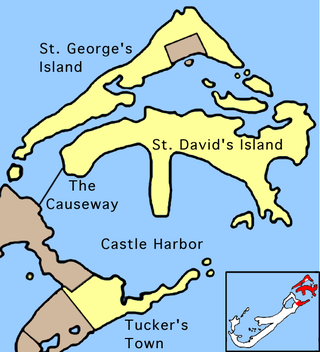
The Causeway is a narrow strip of reclaimed land and bridges in the north of Bermuda linking Hamilton Parish on the mainland in the southwest and Bermuda International Airport on St. David's Island in St. George's Parish in the northeast, which are otherwise divided by Castle Harbour.

Smith's Island is part of the chain which makes up Bermuda. It is located in St. George's Parish, in the northeast of the territory.

<span class="mw-page-title-main">Castle Island, Bermuda</span>

Castle Island is part of the chain which makes up Bermuda. It is located in St. George's Parish, in the northeast of the territory.

<span class="mw-page-title-main">St. George's Island, Bermuda</span> One of the principal islands of Bermuda

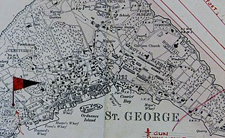
St. George's Island is one of the main islands of the territory of Bermuda and lies within St. George's Parish at the East End of the archipelago. St. George's Town, the original colonial capital, is located on the southern shore near the eastern end of the island. The island covers 703 acres, and is one of the six principal islands of Bermuda.

<span class="mw-page-title-main">St. George's Harbour, Bermuda</span>

St. George's Harbour is a natural harbour in the north of Bermuda. It serves as the port for the town of St. George's, located on St. George's Island, to its north. To its south is St. David's Island. The harbour and both islands lie within St. George's Parish. It was for two centuries the primary harbour of the British Overseas Territory.

<span class="mw-page-title-main">Bermuda Militia (1612–1687)</span> Colonial militia in Bermuda from 1612 to 1687

Between 1612 and 1687, Bermuda had a series of militias under the Virginia Company, the Somers Isles Company, and the British Crown. In 1687, the first Militia Act was enacted.

<span class="mw-page-title-main">Architecture of Bermuda</span>

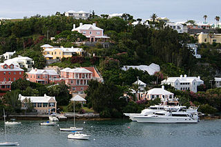
The architecture of Bermuda has developed over the past four centuries. The archipelago's isolation, environment, climate, and scarce resources have been key driving points, though inspiration from Europe, the Caribbean and the Americas is evident. Distinctive elements appeared with initial settlement in the early 17th century, and by the second half of that century features that remain common today began to appear.

<span class="mw-page-title-main">Castle Islands Fortifications, Bermuda</span> Historic site in Castle Harbour, Bermuda

Several of the islands strung across the South entrance of Castle Harbour, Bermuda were fortified in the early days of the territory, hence the harbour's name. When official settlement of the archipelago by England began in 1612 the first permanent town, St. George's was placed on the North side of St. George's Harbour. St. George's Harbour could be accessed directly by channels from the East. Those channels, however, were shallow, suitable, originally, only for small ships. As a consequence, and despite any major settlement on its shores, Castle Harbour was an important anchorage in the early years of the colony, with its main entrance, Castle Roads being an important route in from the open Atlantic for shipping. It was also a weak point, as it was remote from the defences of St. George's Harbour, and difficult to reach. It was quickly fortified and garrisoned by a standing militia.

<span class="mw-page-title-main">Castle Roads</span>

Castle Roads is the primary channel by which vessels enter Castle Harbour, Bermuda, from the Atlantic Ocean. Although little used, today, except by pleasure boats, Castle Harbour was once an important anchorage, and an access route used by ships to reach the still important St. George's Harbour. The infilling of waterways between St. David's Island and Long Bird Island in the 1940s, as well as the Causeway joining the contiguous landmass so created means only small boats can pass between the two Harbours, today. It was once common to use the term roads in reference to a waterway. Other examples include Hampton Roads, in Virginia, and Lahaina Roads, in Hawaii.

<span class="mw-page-title-main">Fort St. Catherine</span> Historic site in St. Georges Island, Bermuda

Fort St. Catherine, or Fort St. Catherine's, is a coastal artillery fort at the North-East tip of St. George's Island, in the Imperial fortress colony of Bermuda. Successively redeveloped, the fort was used first by Bermudian Militia and then by regular Royal Artillery units from 1612 into the 20th century. Today it houses a museum.

<span class="mw-page-title-main">Historic Town of St George and Related Fortifications, Bermuda</span> UNESCO World Heritage Site in British Overseas Territories, United Kingdom

The Historic Town of St George and Related Fortifications is the name used by the United Nations Educational, Scientific and Cultural Organization's (UNESCO) World Heritage Committee to identify collectively as a World Heritage Site St. George's Town, founded in 1612, and a range of fortifications, batteries, and magazines built between 1612 and 1939, the last of which was removed from use in 1953.

<span class="mw-page-title-main">Western Redoubt</span>

The Western Redoubt, or Fort William, is a square fort built on a crest on the eastern side of Government Hill, and within the boundaries of the original main British Army camp in the Imperial fortress colony of Bermuda, St. George's Garrison.

<span class="mw-page-title-main">Fort Victoria, Bermuda</span> Historic site in St. Georges Island, Bermuda

Fort Victoria is a disused British Army fort, built to house coastal artillery atop Retreat Hill, within St. George's Garrison, at the North-East of St. George's Island, in the British colony of Bermuda.

<span class="mw-page-title-main">St. George's Garrison, Bermuda</span> British military post

St. George's Garrison was the first permanent military camp of the Bermuda Garrison established in the British colony and Imperial fortress of Bermuda, with construction of Old Military Road and the original Royal Barracks commencing during the war between Britain and France that followed the French Revolution. It would remain in use until 1957, when it was transferred to the civil (colonial) government with most of the other Admiralty and War Office properties in Bermuda.

<span class="mw-page-title-main">Scaur Hill Fort, Bermuda</span>

Scaur Hill Fort, also called Scaur Hill Lines and Somerset Lines, is a fortified position erected in the 1870s at Scaur Hill, on Somerset Island, in Sandys Parish, the westernmost parish of the Imperial fortress colony of Bermuda.

<span class="mw-page-title-main">Fort George, Bermuda</span>

Fort George is a square fort built on the crest of Mount Hill to the west of St. George's Town, near to, but outside of the boundaries of the original main British Army camp in the Imperial fortress colony of Bermuda, St. George's Garrison.

References

  1. Rider's Bermuda: a guide book for ... – Google Books
  2. Verrill, Addison Emery (1902). The Bermuda Islands: An Account of Their Scenery, Climate, Productions, Physiography, Natural History and Geology, with Sketches of Their Discovery and Early History, and the Changes in Their Flora and Fauna Due to Man. p. 439. ISBN   9780341970989.
  3. "Weatherbase: Historical Weather for Castle Harbour, Bermuda". Weatherbase. 2011. Retrieved on November 24, 2011.
  4. 1 2 Adventure guide to Bermuda – Google Books
  5. Bermuda Attractions: Ferry Island Fort