
Antigua Guatemala, commonly known as Antigua or La Antigua, is a city in the central highlands of Guatemala. The city was the capital of the Captaincy General of Guatemala from 1543 through 1773, with much of its Baroque-influenced architecture and layout dating from that period. These characteristics had it designated as a UNESCO World Heritage Site in 1979. Antigua Guatemala serves as the capital of the homonymous municipality and the Sacatepéquez Department.

Livingston is a town, with a population of 17,923, in Izabal Department, eastern Guatemala, at the mouth of the Río Dulce at the Gulf of Honduras. The town serves as the municipal seat of the municipality of the same name. It was Guatemala's main port on the Caribbean Sea before the construction of nearby Puerto Barrios.

Izabal is one of the 22 departments of Guatemala. Its coastal areas form part of the homeland of the Garifuna people.

Puerto Barrios is a city in Guatemala, located within the Gulf of Honduras. The city is located on Bahia de Amatique. Puerto Barrios is the departmental seat of Izabal department and is the administrative seat of Puerto Barrios municipality.
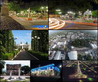
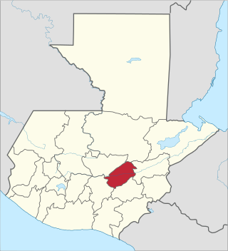
Chiquimula is one of the 22 departments of Guatemala, in Central America. The departmental capital is also called Chiquimula. The department was established by decree in 1871, and forms a part of the southeastern region of Guatemala. Physically, it is mountainous, with a climate that varies between tropical and temperate, depending on the location.
El Progreso is a department in Guatemala. The departmental capital is Guastatoya. The Spanish established themselves in the region by 1551, after the Spanish conquest of Guatemala. El Progreso was declared a department in 1908, but was dissolved in 1920 before being reestablished in 1934. Guastatoya was badly affected by the 1976 Guatemala earthquake.

Huehuetenango is one of the 22 departments of Guatemala. It is located in the western highlands and shares the borders with the Mexican state of Chiapas in the north and west; with El Quiché in the east, and Totonicapán, Quetzaltenango and San Marcos in the south. The capital is the city of Huehuetenango.
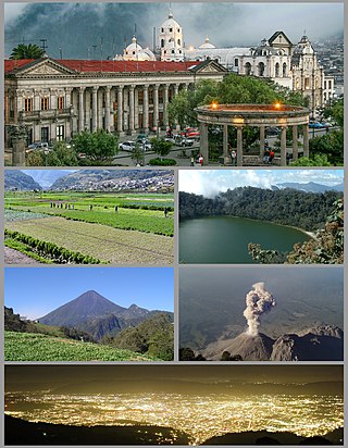
Quetzaltenango is a department in the western highlands of Guatemala. The capital is the city of Quetzaltenango, the second largest city in Guatemala. The department is divided up into 24 municipalities. The inhabitants include Spanish-speaking Ladinos and the Kʼicheʼ and Mam Maya groups, both with their own Maya language. The department consists of mountainous terrain, with its principal river being the Samalá River. the department is seismically active, suffering from both earthquakes and volcanic activity.

San Juan National Historic Site in the Old San Juan section of San Juan, Puerto Rico, is a National Park Service-managed historic site which preserves and interprets the Spanish colonial-era fortification system of the city of San Juan, and features structures such as the San Felipe del Morro and San Cristóbal fortresses. This fortification system is the oldest European construction under United States jurisdiction and one of the oldest in the New World. This national historic site, together with La Fortaleza, have been designated a UNESCO World Heritage Site since 1983.

In a protracted conflict during the Spanish colonization of the Americas, Spanish colonisers gradually incorporated the territory that became the modern country of Guatemala into the colonial Viceroyalty of New Spain. Before the conquest, this territory contained a number of competing Mesoamerican kingdoms, the majority of which were Maya. Many conquistadors viewed the Maya as "infidels" who needed to be forcefully converted and pacified, disregarding the achievements of their civilization. The first contact between the Maya and European explorers came in the early 16th century when a Spanish ship sailing from Panama to Santo Domingo was wrecked on the east coast of the Yucatán Peninsula in 1511. Several Spanish expeditions followed in 1517 and 1519, making landfall on various parts of the Yucatán coast. The Spanish conquest of the Maya was a prolonged affair; the Maya kingdoms resisted integration into the Spanish Empire with such tenacity that their defeat took almost two centuries.
Dulce River is a river in Guatemala, completely contained within the department of Izabal. It is part of a lake and river system that has become a popular cruising sailboat destination.

Morales is a municipality in Izabal Department of Guatemala. The municipality was created in 1920 and is formed by the town of Morales, 9 villages and 56 rural communities. The Cuevas del Silvino National Park is located a few kilometers northeast of Morales.

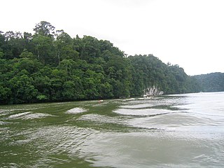
Lake Izabal, also known as the Golfo Dulce, is the largest lake in Guatemala with a surface area of 589.6 km2 and a maximum depth of 18 m (59 ft). The Polochic River is the largest river that drains into the lake. The lake, which is only a metre above sea level, drains into the Gulf of Honduras of the Caribbean Sea through the smaller Golfete Dulce, which is at sea level, and the navigable Rio Dulce.
The Spanish conquest of the Maya was a protracted conflict during the Spanish colonisation of the Americas, in which the Spanish conquistadores and their allies gradually incorporated the territory of the Late Postclassic Maya states and polities into the colonial Viceroyalty of New Spain. The Maya occupied the Maya Region, an area that is now part of the modern countries of Mexico, Guatemala, Belize, Honduras and El Salvador; the conquest began in the early 16th century and is generally considered to have ended in 1697.
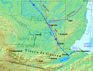
The Spanish conquest of Petén was the last stage of the conquest of Guatemala, a prolonged conflict during the Spanish colonisation of the Americas. A wide lowland plain covered with dense rainforest, Petén contains a central drainage basin with a series of lakes and areas of savannah. It is crossed by several ranges of low karstic hills and rises to the south as it nears the Guatemalan Highlands. The conquest of Petén, a region now incorporated into the modern republic of Guatemala, climaxed in 1697 with the capture of Nojpetén, the island capital of the Itza kingdom, by Martín de Ursúa y Arizmendi. With the defeat of the Itza, the last independent and unconquered native kingdom in the Americas fell to European colonisers.
Locura de amor is a Mexican telenovela produced by Roberto Gómez Fernández for Televisa that premiered on May 1, 2000 and ended on October 6, 2000. The series is a remake of the 1988 telenovela Dulce Desafío. It stars Juan Soler and Adriana Nieto, Laisha Wilkins, Juan Peláez and Gabriela Platas.

The Manche Chʼol were a Maya people who constituted the former Manche Chʼol Territory, a Postclassic polity of the southern Maya Lowlands, within the extreme south of what is now Petén and the area around Lake Izabal in northern Guatemala, and southern Belize. The Manche Chʼol took the name Manche from the name of their main settlement. They were the last of a set of Ch'olan-speaking groups in the eastern Maya Lowlands to remain independent and ethnically distinct. It is likely that they were descended from the inhabitants of Classic period Maya cities in the southeastern Maya Lowlands, such as Nim Li Punit, Copán and Quiriguá.
Tourism became one of the main drivers of Guatemala's economy, an industry that reported more than $1.8 billion in 2008. Guatemala receives about two million tourists annually.
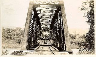
The Northern Railroad of Guatemala was a railway system that ran from Guatemala City to Puerto Barrios, the main port of Guatemala, between 1896 and 1968. The American United Fruit Company had the monopoly of the railway system through its affiliate, International Railways of Central America, along with the docks at Puerto Barrios, the banana plantations in Izabal and the cargo and passenger transport with its Great White Fleet. The system was highly efficient, but once a parallel highway was built, it could not compete and eventually was handed back to the State of Guatemala in 1968. After that, the system slowly lost its relevance, as the trucks were more profitable than railway transportation along this route. It ceased regular operations in 1996, and has remained partially abandoned since.

