Catalan Pre-Coastal Range

Last updated
Geomorphologic map of Catalonia:
Pyrenees
Pre-Pyrenees
Catalan Central Depression
Smaller mountain ranges of the Central Depression
Catalan Transversal Range
Catalan Pre-Coastal Range
Catalan Coastal Range
Catalan Coastal Depression and other coastal and pre-coastal plains Catmorfo.png
Geomorphologic map of Catalonia:
Pyrenees Range of mountains in southwest Europe

The Pyrenees is a range of mountains in southwest Europe that forms a natural border between Spain and France. Reaching a height of 3,404 metres (11,168 ft) altitude at the peak of Aneto, the range separates the Iberian Peninsula from the rest of continental Europe, and extends for about 491 km (305 mi) from the Bay of Biscay to the Mediterranean Sea.

Pre-Pyrenees

The Pre-Pyrenees are the foothills of the Pyrenees.

Catalan Central Depression

The Catalan Central Depression is a natural depression between the Pre-Pyrenees and the Catalan Pre-Coastal Range in Spain. It widens towards the west, linking with the Ebro Depression, Catalan: Depressió de l'Ebre, of which it could be considered an eastern extension. The Catalan Central Depression is about 180 km long with an average width of 50 km.

The Turo de l'Home, highest summit of the Montseny Massif Observatori Turo de l'Home.JPG
The Turo de l'Home, highest summit of the Montseny Massif

The Catalan Pre-Coastal Range (Catalan : Serralada Prelitoral Catalana) is a system of mountain ranges running parallel to the Mediterranean Sea coast in Catalonia. It is part of the Catalan Mediterranean System. Its main axis runs between the Catalan Transversal Range and the Serra de l'Espina, which connects with the Ports de Tortosa-Beseit, part of the Iberian System. The highest point is 1.706,7 m at the Montseny Massif.

Catalan language Romance language

Catalan is a Western Romance language derived from Vulgar Latin and named after the medieval Principality of Catalonia, in northeastern modern Spain. It is the only official language of Andorra, and a co-official language of the Spanish autonomous communities of Catalonia, the Balearic Islands and Valencia. It also has semi-official status in the Italian commune of Alghero. It is also spoken in the eastern strip of Aragon, in some villages of Region of Murcia called Carche and in the Pyrénées-Orientales department of France. These territories are often called Països Catalans or "Catalan Countries".

Mediterranean Sea Sea connected to the Atlantic Ocean between Europe, Africa and Asia

The Mediterranean Sea is a sea connected to the Atlantic Ocean, surrounded by the Mediterranean Basin and almost completely enclosed by land: on the north by Southern Europe and Anatolia, on the south by North Africa and on the east by the Levant. Although the sea is sometimes considered a part of the Atlantic Ocean, it is usually identified as a separate body of water. Geological evidence indicates that around 5.9 million years ago, the Mediterranean was cut off from the Atlantic and was partly or completely desiccated over a period of some 600,000 years, the Messinian salinity crisis, before being refilled by the Zanclean flood about 5.3 million years ago.

Catalonia Autonomous area of northeastern Spain

Catalonia is an autonomous community in Spain on the northeastern corner of the Iberian Peninsula, designated as a nationality by its Statute of Autonomy. Catalonia consists of four provinces: Barcelona, Girona, Lleida, and Tarragona. The capital and largest city is Barcelona, the second-most populated municipality in Spain and the core of the sixth most populous urban area in the European Union. It comprises most of the territory of the former Principality of Catalonia. It is bordered by France (Occitanie) and Andorra to the north, the Mediterranean Sea to the east, and the Spanish autonomous communities of Aragon to the west and Valencia to the south. The official languages are Catalan, Spanish, and the Aranese dialect of Occitan.

Contents

Mountain ranges

From North to South:

Montseny Massif mountain

Montseny is a mountain range west of the coastal hills north of Barcelona. It is part of the Catalan Pre-Coastal Range.

Montserrat (mountain) multi-peaked mountain in Catalonia, Spain

Montserrat is a multi-peaked mountain range near Barcelona, in Catalonia, Spain. It is part of the Catalan Pre-Coastal Range. The main peaks are Sant Jeroni, Montgrós and Miranda de les Agulles.

Picorandan mountain in Spain

Picorandan is a mountain of Catalonia, Spain. It is part of the Catalan Pre-Coastal Range. Its maximum elevation is 991 metres above sea level.

Ecology

The protected areas in the Catalan Pre-Coastal Range are: Parc Natural del Montseny, Parc Natural de Sant Llorenç del Munt i l'Obac, Parc Natural de Montserrat, Parc Natural dels Ports de Tortosa-Beseit and Parc Natural de la Serra de Montsant.

See also

Catalan Coastal Range

The Catalan Coastal Range is a system of mountain ranges running parallel to the Mediterranean Sea coast in Catalonia, Spain. It is part of the Catalan Mediterranean System. Its main axis runs between the Foix River and the Roses Gulf and the average altitude is around 500 m. The highest point is 763 m at the Montnegre.

Related Research Articles

Vallès Occidental Comarca in Catalonia, Spain

Vallès Occidental is a comarca (county) in Catalonia, Spain. It is unique among the comarques in that the two cities Sabadell and Terrassa share the role of comarcal capital. Along with Vallès Oriental it forms the grand comarca of Vallès.

Ports de Tortosa-Beseit mountain

Ports de Tortosa-Beseit, also known as Ports de Beseit, or simply as Els Ports[əls ˈpɔɾts] or Lo Port[lu ˈpɔɾt] by locals, is a limestone mountain massif located at the north-eastern end of the Sistema Ibérico, a complex system of mountain ranges and massifs in the centre of the Iberian Peninsula. Its highest point is Mont Caro, 1,441 m. Rivers such as the Matarranya and the Sénia have their source in these mountains.

Montcau mountain in Spain

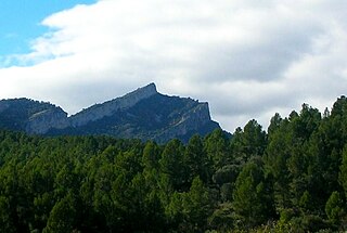
Montcau is a mountain of Catalonia, Spain. It has an elevation of 1,056 metres (3,465 ft) above sea level. This mountain is part of the Sant Llorenç del Munt massif. It is accessible from Terrassa or Navarcles or Sant Llorenç Savall.

Serra de Montsant mountain range

Serra de Montsant is a mountain chain in Catalonia, Spain. The main populated area in the range is La Morera de Montsant.

Serra de lEspina mountain in Spain

Serra de l'Espina is a limestone mountain chain located at the north-eastern end of the Iberian System. It connects the Ports de Tortosa-Beseit mountain massif with the Catalan Pre-Coastal Range.

Tinença de Benifassà historical comarca of the Valencian Community, Spain

Tinença de Benifassà is a historical comarca of the Valencian Community, Spain. It is nowadays part of the Baix Maestrat, one of the present-day Comarques of the Valencian Community, even though commercial and human relationships have been stronger with Els Ports in the west, the Terres de l'Ebre in the northeast and the Matarranya in the northwest in historical times.

Serra dIrta mountain in the Land of Valencia

Serra d'Irta is an 18.8 km long mountain range in the Baix Maestrat comarca, Valencian Community, Spain. Its highest point is Pic Campanilles.

Serra de Paüls mountain in Spain

Serra de Paüls is a mountain range in the northern side of the Ports de Tortosa-Beseit, Catalonia, Spain. The highest summit, Punta de l'Aigua has an elevation of 1,091.6 metres above sea level.

Sant Llorenç del Munt mountain

Sant Llorenç del Munt is a largely rocky mountain massif in central Catalonia, Spain. The highest summit, where the Monestir de Sant Llorenç del Munt is located, has an elevation of 1,104.2 metres (3,623 ft) above sea level and is known as La Mola. Montcau 1,056.8 metres (3,467 ft) is another important peak of the massif. On the massif, there is a protected area under the name Parc Natural de Sant Llorenç del Munt i l'Obac.

Turó de la Mamella mountain in Spain

Turó de la Mamella is a mountain of Catalonia, Spain. Located in the Terrassa and Vacarisses municipal limits, it is one of the foothills of the Serra de l'Obac, Catalan Pre-Coastal Range, and has an elevation of 806.6 metres above sea level.

Serra de la Llena mountain in Spain

Serra de la Llena, also known as Serra la Llena, is a mountain chain straddling the municipal terms of Vilanova de Prades, La Pobla de Cérvoles (Garrigues) and Ulldemolins (Priorat), in Catalonia, Spain. These mountains have characteristic large and rounded rocky outcrops.

Prades Mountains mountain in Spain

Prades Mountains, also known as Muntanyes de Prades, is a large calcareous mountain massif straddling the comarcas of Alt Camp, Baix Camp, Conca de Barberà, Garrigues and Priorat, in Catalonia, Spain. They are a Site of Community Importance.

Cardó Massif

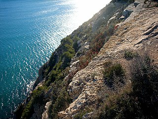
The Cardó Massif, also known as Cardó-Boix Massif, is a mountain massif in the Baix Ebre comarca, in Catalonia, Spain. This massif is composed of a number of mountain ranges located on the left side of the Ebro river near Tortosa. The massive calcareous cliffs of the Serra de Cardó form the eastern side of the spectacular gorges through which the Ebro River winds its way in the final stage of its course, separating the Ebro Valley from the Mediterranean coastal area.

Garraf Massif mountain range

The Garraf Massif is a mountain range of the Catalan Coastal Range, Catalonia, Spain. Its cliffs reach the Mediterranean waters. Its highest point on the coastal side is La Morella, 593 metres above sea level and further inland rises the higher, although less conspicuous, Montau.

Serra de Llaberia mountain in Spain

Serra de Llaberia is a mountain chain in Catalonia, Spain located between the Prades and the Tivissa-Vandellòs Mountains.

Mola de Colldejou mountain in Spain

Mola de Colldejou is a mountain chain in Catalonia, Spain located north of the Serra de Llaberia in the Catalan Pre-Coastal Range. The highest point is 921.8 m above sea level.

Monestir de Sant Llorenç del Munt cultural property in Matadepera, Spain

Sant Llorenç del Munt is a Benedictine monastery in Matadepera, Vallès Occidental, Catalonia, Spain. It is situated on top of La Mola, the summit of the rocky mountain massif, Sant Llorenç del Munt, within Parc Natural de Sant Llorenç del Munt i l'Obac. It was declared a Bien de Interés Cultural landmark in 1931.

References

  1. Gepec.org Serra del Montsià Archived 2011-07-26 at the Wayback Machine .

Coordinates: 41°36′55″N1°47′16″E / 41.61528°N 1.78778°E / 41.61528; 1.78778