
Montserrat is a multi-peaked mountain range near Barcelona, in Catalonia, Spain. It is part of the Catalan Pre-Coastal Range. The main peaks are Sant Jeroni, Montgrós and Miranda de les Agulles.

Olot is the capital city of the comarca of Garrotxa, in the Province of Girona, Catalonia, Spain. The city is known for its natural landscape, including four volcanoes scattered around the city center. The municipality is part of the Zona Volcànica de la Garrotxa Natural Park. Olot is also well known for its cultural activity, with historical art movements like Olot school or factories of religious imagery, which contributed to the location in the city of the main Design and Arts & Crafts school of the province of Girona, the Escola d'Art i Superior de Disseny d'Olot.
Barcelona is a province of eastern Spain, in the center of the autonomous community of Catalonia. The province is bordered by the provinces of Tarragona, Lleida, and Girona, and by the Mediterranean Sea. Its area is 7,726 km2 (2,983 sq mi). 5,743,402 people live in the province, of whom about 29% (1,664,182) live within the administrative limits of the city of Barcelona, which itself is contained in the Barcelona metropolitan area.

Berguedà is an inland comarca (county) in Catalonia, Spain, lying partly in the Pyrenees and Pre-Pyrenees, and partly in the Catalan Central Depression.

Garrotxa is a comarca (county) in Girona, Catalonia, Spain. Its population in 2016 was 55,999, more than half of them in the capital city of Olot. It is roughly equivalent to the historical County of Besalú.

Gironès is a comarca (county) in eastern Catalonia, Spain, bordering Selva, Baix Empordà, Alt Empordà, Pla de l'Estany and Garrotxa. As of 2008, more than half of the comarca's 175,148 inhabitants live in the capital, Girona, which is also the capital of the province of Girona.
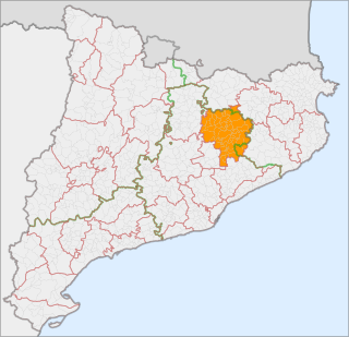
Osona is a comarca situated in Catalonia, Northeast Spain. Its capital is Vic. Its population in 2001 was 129,543. Osona covers roughly the same area as the historic Catalan county of Osona. The name Osona comes from Ausetans, a group of Iberian people who had their capital in Ausa ; the Romans called the area Ausone or Ausona. While most of the comarca is within the province of Barcelona, the municipalities of Espinelves, Vidrà and Viladrau form part of the province of Girona.
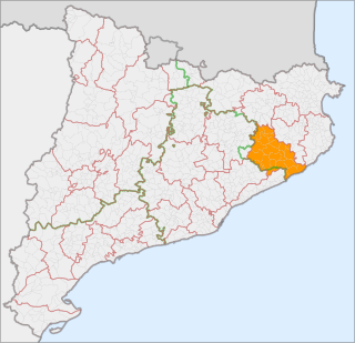
Selva is a coastal comarque (county) in Catalonia, Spain, located between the mountain range known as the Serralada Transversal or Puigsacalm and the Costa Brava. Unusually, it is divided between the provinces of Girona and Barcelona, with Fogars de la Selva being part of Barcelona province and all other municipalities falling inside Girona province. Also unusually, its capital, Santa Coloma de Farners, is no longer among its larger municipalities, with the coastal towns of Blanes and Lloret de Mar having far surpassed it in size.

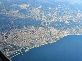
The Costa Brava is a coastal region of Catalonia in northeastern Spain, consisting of the comarques (counties) of Alt Empordà, Baix Empordà and Selva in the province of Girona. Costa Brava stretches from the town of Blanes, 60 km (37 mi) northeast of Barcelona, to the French border. In the 1950s, the Costa Brava was identified by the Spanish government and local entrepreneurs as being suitable for substantial development as a holiday destination, mainly for package holiday tourists from Europe. The combination of a very good summer climate, nature, excellent beaches and a favourable foreign exchange rate, which made Costa Brava an attractive tourist destination, was exploited by the construction of large numbers of hotels and apartments in such seaside resorts as Blanes, Tossa de Mar and Lloret de Mar. Tourism rapidly took over from fishing as the principal business of the area.

Vilanova de Sau is a town in the comarca of the Osona in Catalonia, eastern Spain. It is situated in the valley called Sau. The Ter river runs through the valley, now damed into Pantà de Sau, a reservoir which is in the municipal territory of Vilanova de Sau, and is a tourist attraction and base for water sports and hiking. The reservoir houses the submerged village of church of Sant Romà.

Eix Transversal, labelled C-25, is a primary highway in Catalonia, Spain. It crosses the Catalan Transversal Range mountainous region, connecting the northern end of the Catalan Coastal Depression with the Catalan Central Depression.

Puigsacalm is the highest mountain of the Catalan Transversal Range, Catalonia, Spain. It has an elevation of 1,512 metres above sea level.

Sant Miquel de Solterra or Sant Miquel de les Formigues is the highest mountain of the Guilleries Massif, Catalonia, Spain. It has an elevation of 1,201.9 metres above sea level.

Mare de Déu del Mont, also known as Serra del Mont, is a mountain range of the Alta Garrotxa natural region, Catalonia, Spain. It has an elevation of 1,123 metres above sea level.

Sant Roc, also known as Sant Roc d'Amer, Sant Roc de la Barroca and Grony, is a mountain of the Catalan Transversal Range, Catalonia, Spain. It has an elevation of 591 metres above sea level. It is part of the range that separates the Llémena River and the Brugent river valleys and is located at the confluence of the Garrotxa, el Gironès and la Selva comarques. This mountain has a striking appearance and is quite visible from the road between Bonmatí and Sant Martí de Llémena. The steep cliffs on the southern and northeastern sides of the mountain are known as Cingles de Sant Roc.

The Catalan Mediterranean System, also known as Mediterranean System, Transversal Ibero-Pyrenaean System, and Catalanid System, is a wide coastal geographical region in Catalonia. It is made up of a double system of coastal mountain chains: The Catalan Coastal Range and the Catalan Pre-Coastal Range, as well as the Catalan Coastal Depression and other coastal and pre-coastal plains located among those mountain ranges.
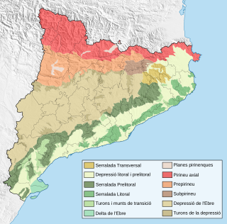
The Sub-Pyrenees are a mountainous region in Catalonia, Spain, forming a section of the southern foothills of the Pyrenees. They are located at the eastern end of the Pre-Pyrenees, west of the Catalan Transversal Range, between the lower Ripollès and an area of the high Garrotxa.

The Plain of Vic is a 30 km long depression located at the eastern end of the Catalan Central Depression in the Osona comarca. It is named after the town of Vic, an important and ancient urban center in this natural region that lies in the midst of the plain. Other significant towns in the plain are Manlleu and Tona.
The Guilleries Massif is a mountain system located at the apex of the Catalan Transversal Range and the Pre-Coastal Range. The highest point of the range is Sant Miquel de Solterra or Sant Miquel de les Formigues, other main peaks are Turó del Faig Verd, Rocallarga, Sant Benet, El Far, Sant Gregori, Montdois, L'Agullola and Turó del Castell
The Catalan Central Depression is a natural depression between the Pre-Pyrenees and the Catalan Pre-Coastal Range in Spain. It widens towards the west, linking with the Ebro Depression, Catalan: Depressió de l'Ebre, of which it could be considered an eastern extension. The Catalan Central Depression is about 180 km long with an average width of 50 km.

