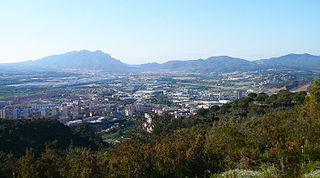
Martorell is a municipality, county, and city that forms part of the Baix Llobregat comarca, in Catalonia, Spain, primarily known for its medieval Devil's bridge. It lies at the confluence of the Llobregat and Anoia rivers.
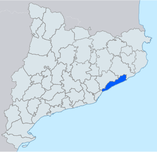
Maresme is a comarca (county) in the Barcelona region in Catalonia, located along the Mediterranean coast, between the comarques of Barcelonès and Selva, and also bordering with Vallès Oriental.
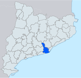
Baix Llobregat is a comarca (county) on the coast of Catalonia, Spain. It is located in the Barcelona region and its capital is Sant Feliu de Llobregat.

Osona is a comarca situated in the central region of Catalonia, Spain. Its capital is Vic. Its population in 2001 was 129,543. Osona covers roughly the same area as the historic Catalan county of Osona. The name Osona comes from Ausetans, a group of Iberian people who had their capital in Ausa ; the Romans called the area Ausone or Ausona. While most of the comarca is within the province of Barcelona, the municipalities of Espinelves, Vidrà and Viladrau form part of the province of Girona.

Vallès Occidental is a comarca (county) in the Barcelona region in Catalonia (Spain). It has two capitals, Sabadell and Terrassa. Along with Vallès Oriental, it forms the historical Vallès region.

Sant Adrià de Besòs is a city and a municipality within the comarca of Barcelonès in Catalonia, north-eastern Spain. It is situated on the Mediterranean coast, at the mouth of river Besòs, extending to both sides of the estuary although the original settlement with the parish church lies on the left bank of the river, in the northern part of town. Sant Adrià is the smallest municipality of Barcelonès and has close ties with the neighbouring cities of Barcelona, Badalona and Santa Coloma de Gramenet, forming a uniform urban area within Barcelona metropolitan area.

Ponts is a municipality and a town in the comarca of the Noguera in the province of Lleida, Catalonia, Spain. It is situated on the left bank of the Segre river near its confluence with the Llobregós river and at the point where the routes from Calaf and Cervera meet the route from Lleida to La Seu d'Urgell.

Ripollet is a municipality in the comarca of the Vallès Occidental in Catalonia, Spain. It is situated on the left bank of the Ripoll river. The town is served by the AP-7, C-58 and C-33 highways, the N-150 road and a RENFE railway line.

Vilanova de Sau is a town in the comarca of the Osona in Catalonia, eastern Spain. It is situated in the valley called Sau. The Ter river runs through the valley, now dammed into Pantà de Sau, a reservoir which is in the municipal territory of Vilanova de Sau, and is a tourist attraction and base for water sports and hiking. The reservoir houses the submerged Church of Sant Romà.

Agramunt is a municipality (municipi) in the comarca of the Urgell in Catalonia. It is situated in the north of the comarca, near the border with the Noguera. The town centre is protected as a historic-artistic monument, especially the Roman church of Santa Maria which dates from the 12th-13th centuries. The town is also known for the production of torró d'Agramunt, a sort of confectionery traditionally eaten at Christmas. The town is linked to Tàrrega by the C-240 road, to Cervera by the L-303 road and to Artesa de Segre by the L-302 road. The Urgell canal passes through the municipality, crossing the Montclar range through a tunnel. The municipality includes the exclave of Montclar d'Urgell to the north-west.

Prats de Lluçanès is a municipality in the comarca of Lluçanès in Catalonia, Spain. It is situated in the west of the comarca, on a plain between the Lluçanès and Merlès rivers, and is served by the C-154 road between Vic and Gironella.

C-32 is a primary highway in Catalonia, Spain. It was created in 2004 by merging three sections of existing autopistas and autovías. This re-organisation was part of a renaming of primary highways managed by the Generalitat de Catalunya. According to this new denomination, the first number (C-32) indicates that is a southwest-northeast highway, while the second number (C-32) indicates that is the second-closest to the Mediterranean Sea.

C-16 or Eix del Llobregat is a primary highway in Catalonia, Spain. It is also part of the European route E9, from Orléans (France) to Barcelona.

Autovía A-26 is a long-term project of the Spanish government to upgrade the N-260 national road, also known as Eje Pirenaico or Eix Pirenenc.

C-31 or Eix Costaner is one of Catalonia's primary highways. It is the result of merging several sections of previously existing roads, autopistas and autovías after the 2004's renaming of primary highways managed by the Generalitat de Catalunya. According to this new denomination, the first number (C-31) indicates that is a southwest-northeast highway, while the second number (C-31) indicates that is the closest to the Mediterranean Sea.

The C-35 is a highway in Catalonia, Spain. It connects the Costa Brava with the Autopista AP-7 to Barcelona.
C-17 or Eix del Congost is a primary highway in Catalonia, Spain. According to the 2004's new coding for primary highways managed by the Generalitat de Catalunya, the first number (C-17) indicates that is a south-northbound highway, whereas the second number (C-17) indicates that is the seventh westernmost.

The Catalan Transversal Range is a system of minor mountain ranges at the eastern end of the Pre-Pyrenees, between the Osona and Garrotxa comarques. The existence of the Catalan Transversal Range has made communications in the northern areas of Catalonia difficult in the past, especially between Northeastern Catalonia and Western Catalonia, a problem that has been partly solved with the development of the Eix Transversal.

The B-10, also known as Ronda Litoral, is a 20-kilometre (12.43 mi) freeway in Catalonia, Spain partially encircling Barcelona passing through the eastern side of the city. It starts at Nus de la Trinitat interchange in northern Barcelona and runs along the entire length of the Besòs River and the city's coastline south to Nus del Llobregat interchange in Barcelona's southern suburbs, where it becomes the Autovía A-2. Both north and south end interchanges link the freeway to the B-20 or Ronda de Dalt, which encircles Barcelona passing through the western side, jointly forming a beltway commonly referred to as the rondes that surrounds the city.

