A limited-access road, known by various terms worldwide, including limited-access highway, dual-carriageway, expressway, and partial controlled-access highway, is a highway or arterial road for high-speed traffic which has many or most characteristics of a controlled-access highway, including limited or no access to adjacent property, some degree of separation of opposing traffic flow, use of grade separated interchanges to some extent, prohibition of slow modes of transport, such as bicycles, horse-drawn vehicles or ridden horses, or self-propelled agricultural machines; and very few or no intersecting cross-streets or level crossings. The degree of isolation from local traffic allowed varies between countries and regions. The precise definition of these terms varies by jurisdiction.

The expressways of Japan make up a large network of controlled-access toll expressways.
Puerto Rico Highway 52 (PR-52), a major toll road in Puerto Rico, is also known as Autopista Luis A. Ferré. It was formerly called Expreso Las Américas. It runs from PR-1 in southwest Río Piedras and heads south until it intersects with highway PR-2 in Ponce. At its north end, the short PR-18 continues north from PR-52 towards San Juan. This short segment is known as Expreso Las Américas, the only segment of the route still unofficially bearing this name, since PR-18 is officially named Roberto Sánchez Vilella Expressway. The combined route of PR-18 and PR-52 runs concurrent with the unsigned Interstate Highway PRI-1. Toll stations are located in San Juan, Caguas, Salinas, Juana Díaz, and Ponce.
A shadow toll is a contractual payment made by a government per driver using a road to a private company that operates a road built or maintained using private finance initiative funding. Payments are based, at least in part, on the number of vehicles using a section of road, often over a 20- to 30-year period. The shadow tolls or per vehicle fees are paid directly to the company without intervention or direct payment from the users.

Santiago Province is one of the six provinces of the Santiago Metropolitan Region (RM) of central Chile. It encompasses the majority of the population of that region, including 31 of the 36 communities of Greater Santiago. The province spans 2,030.30 km (1,262 mi).
Cintra, S.A. is one of the largest private developers of transport infrastructure in the world. Its assets are fundamentally toll roads and car parks, in which it has a total investment of €16billion. Formerly traded on the Madrid Stock Exchange and part of the Spanish benchmark IBEX 35 stock index, Cintra was reacquired by its former owner Ferrovial in December 2009.

A controlled-access highway is a type of highway that has been designed for high-speed vehicular traffic, with all traffic flow—ingress and egress—regulated. Common English terms are freeway, motorway, and expressway. Other similar terms include throughway or thruway and parkway. Some of these may be limited-access highways, although this term can also refer to a class of highways with somewhat less isolation from other traffic.

The Spanish motorway (highway) network is the third largest in the world, by length. As of 2019, there are 17,228 km (10,705 mi) of High Capacity Roads in the country. There are two main types of such roads, autopistas and autovías, which differed in the strictness of the standards they are held to.

The Autopista AP-2 also known as the Autopista del Nordeste, is a highway (autopista) in the north of Spain that connects the northern coast with the eastern coast of the country. It starts at the city of Zaragoza, passes Lleida and ends at El Vendrell, 70 kilometers west of Barcelona, where it connects with AP-7. It was a toll road, and forms part of the European route E90.

A toll road is a road over which users may travel over on payment of a toll, or fee. Tolls are a form of use tax that pays for the cost of road construction and maintenance, without raising taxes on non-users. Investor's bonds necessary for the construction of the roads are issued and sold with the expectation that the bonds will be paid back with user tolls. The toll roads may be run by government agencies that have bond issuing authority and/or private companies that sell bonds or have other sources of finance. Toll roads are usually a government guaranteed road monopoly that guarantees limited or no competing roads will be built by government agencies for the duration of the bonds. Private toll roads built with money raised from private investors in expectation of making money from the tolls probably dominated early toll roads. Government sponsored toll roads often guarantee a minimum payment to the bond holders if traffic volume and toll collections are less than predicted. If the toll authority is a private company there is often a maximum amount of fees that they may extract from users. Toll road operators are typically responsible for maintaining the roads. After the bonds are paid off the road typically reverts to the government agency that authorized the road and owns the land it was built on. Like most government taxes it is not unusual for tolls to continue to be charged after the bonds have been paid off.
An autovía is one of two classes of major highway in the Spanish road system similar to a British motorway or an American freeway. It is akin to the autopista, the other major highway class, but has fewer features and is never a toll road. Some distinguishing features of an autovía are that it must be divided by a median, it must have restricted access, and it cannot be crossed by other roads. While autopistas are generally new routes, autovías are normally improvements to existing roads, so they may have tighter curves and less safe accesses, often with shorter acceleration lanes. However, both have nominal speed limits of 120 kilometres per hour (75 mph). Rest areas are usually 300 kilometres (190 mi) or 2 hours apart. There is usually a safety lane along the median.
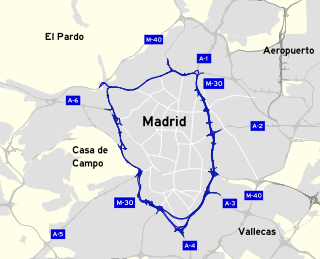
The M-30 orbital motorway circles the central districts of Madrid, the capital city of Spain. It is the innermost ring road of the Spanish city, with a length of 32.5 km. Outer rings are named M-40, M-45 and M-50. Its length and the surface surrounded by the M-30 is comparable to the Boulevard Périphérique of Paris, the Grande Raccordo Anulare of Rome or the London Inner Ring Road.

The A2 motorway is a motorway in the Hrvatsko Zagorje region of northern Croatia, connecting Zagreb to the Macelj border crossing and Slovenia. The A2 motorway is part of the European route E59 and the Pan-European Corridor Xa. The motorway spans 59.2 kilometres (36.8 mi) between the Slovenian border and the Jankomir interchange within the Zagreb bypass, providing road connections to a number of cities and towns besides Zagreb, including Krapina, Zabok and Zaprešić. All sections of the motorway, except the northernmost one between the Macelj border crossing and Trakošćan, and the southernmost one near Zagreb, are tolled, using a closed toll collection system.

The M-40, in Spanish transport, is a Madrid orbital motorway. It is the second-outermost of the Madrid orbital highways, the M-30 being the closest to the centre of Madrid. It surrounds 17 out of the 21 districts of Madrid and the contiguous town of Pozuelo de Alarcón. In terms of length and surface surrounded, it may be compared to London's North and South circular roads, or Paris' A86 super-périphérique.

The M-50 orbital motorway is the outermost ring road of Madrid and its metropolitan area. It has a length of 85 km (53 mi) and, unlike the other ring roads, doesn't form a closed ring, lacking a connection in the northwest between A-6 and A-1. It runs at an average distance of 13.5 km (8.4 mi) from the Puerta del Sol. It is the longest beltway in the Madrid region, and may be compared with London's M25 motorway and Berlin's A10 beltway.
Federal Highway 95D is a toll highway connecting Mexico City to Acapulco, Guerrero. Highway 95D is among the most important toll roads in the country, serving as a backbone for traffic out of Mexico City toward Morelos and tourist destinations in Guerrero.
Federal Highway 15D is the name for toll highways paralleling Federal Highway 15. The toll segments of Highway 15D include some of the most significant highways in the country along the Nogales-Mexico City corridor. The highway is the southern terminus of the CANAMEX Corridor, a trade corridor that stretches from Mexico north across the United States to the Canadian province of Alberta.
Federal Highway 2D is a part of the federal highways corridors, and is the designation for toll highways paralleling Mexican Federal Highway 2. Seven road segments are designated Highway 2D, all but one in the state of Baja California, providing a toll highway stretching from Tijuana in the west to around Mexicali in the east; one in Sonora, between Santa Ana and Altar; and another between the cities of Matamoros and Reynosa in Tamaulipas.
Federal Highway 40D is the designation for toll highways paralleling Mexican Federal Highway 40. Highway 40D connects Mazatlán, Sinaloa to Reynosa, Tamaulipas. It forms most of the highway corridor between Mazatlán and Matamoros, Tamaulipas, one of 14 major highway corridors in the country.