
The A41 is a major trunk road in England that links London and Birkenhead, although it has now in parts been superseded by motorways. It passes through or near various towns and cities including Watford, Kings Langley, Hemel Hempstead, Aylesbury, Solihull, Birmingham, West Bromwich, Wolverhampton, Newport, Whitchurch, Chester and Ellesmere Port.

The Second Happy Time, also known among German submarine commanders as the "American shooting season", was the informal name for a phase in the Battle of the Atlantic during which Axis submarines attacked merchant shipping and Allied naval vessels along the east coast of North America. The first "Happy Time" was in 1940–41 in the North Atlantic and North Sea. Adolf Hitler and Benito Mussolini declared war on the United States on 11 December 1941 so their navies could begin the Second Happy Time.

The European route E 22 is one of the longest European routes. It has a length of about 5,320 km (3,310 mi). Many of the E-roads have been extended into Asia since the year 2000; the E 22 was extended on 24 June 2002.

The Litchfield Council is a local government area of the Northern Territory of Australia on the eastern and southeastern outskirts of the Darwin-Palmerston urban area. The municipality covers an area of 2,914.3 square kilometres (1,125.2 sq mi), and was created by the Northern Territory government on 6 September 1985.

The A452 is a road in England, which runs from Leamington Spa, Warwickshire to Brownhills in West Midlands. It is the major link to the M6 motorway for both Leamington and Warwick in addition to serving as Leamington's link to the M40 motorway and to Coventry.

The Wabash Tunnel is a former railway tunnel and presently an automobile tunnel through Mt. Washington in the city of Pittsburgh, Pennsylvania, United States. Constructed early in the 20th century by railroad magnate George J. Gould for the Wabash Railroad, it was closed to trains and cars between 1946 and 2004.
Airdeny is a village in the Scottish council area of Argyll and Bute.
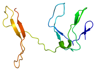
Transcription factor RelB is a protein that in humans is encoded by the RELB gene.

Homeobox protein Hox-D9 is a protein that in humans is encoded by the HOXD9 gene.
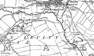
Hooton Levitt is a village and civil parish in the Metropolitan Borough of Rotherham in South Yorkshire, England; one of four villages in the county that carry the name of Hooton, meaning 'farmstead on a spur of land'. It has a population of 110, increasing to 132 at the 2011 Census.
The Roman Catholic Diocese of Bareilly is a diocese located in the city of Bareilly in the Ecclesiastical province of Agra in India.

Taylors Island Wildlife Management Area is a Wildlife Management Area near the community of Taylors Island on the Eastern Shore of the state of Maryland, USA.

The Lac de Gras kimberlite field is a group of Late Cretaceous to Eocene age diatremes in the Northwest Territories, Canada.
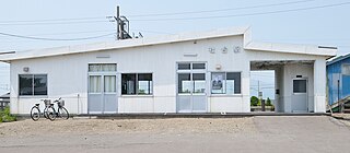
Shadai Station is a train station in Shiraoi, Shiraoi District, Hokkaidō, Japan.
Dağçatı is a village in the District of Sason, Batman Province, Turkey. As of 2011, it had a population of 259 people.
Union Township is a township in Harrison County, in the U.S. state of Missouri.

The Atlantic County Courthouse is the historical courthouse for Atlantic County, New Jersey located in the county seat of Mays Landing, itself a part of Hamilton Township, U.S. It now houses the Office of County Clerk. The Atlantic County Sheriff's Office and older county jails are behind the building.


