
The Canary Islands, also known informally as the Canaries, are a Spanish autonomous community and archipelago in Macaronesia in the Atlantic Ocean. At their closest point to the African mainland, they are 100 kilometres west of Morocco and the Western Sahara. They are the southernmost of the autonomous communities of Spain. The islands have a population of 2.2 million people and are the most populous special territory of the European Union.
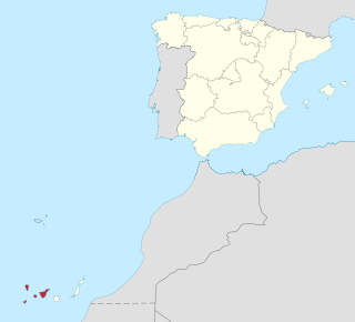
Province of Santa Cruz de Tenerife, also Province of Santa Cruz, is a province of Spain, consisting of the western part of the autonomous community of the Canary Islands. It consists of about half of the Atlantic archipelago: the islands of Tenerife, La Gomera, El Hierro, and La Palma. It occupies an area of 3,381 km2 (1,305 sq mi). It also includes a series of adjacent roques.

Tenerife is the largest and most populous island of the Canary Islands. It is home to 42.9% of the total population of the archipelago. With a land area of 2,034.38 square kilometres (785.48 sq mi) and a population of 948,815 inhabitants as of January 2023, it is also the most populous island of Spain and of Macaronesia.

Santa Cruz de Tenerife, commonly abbreviated as Santa Cruz, is a city, the capital of the island of Tenerife, Province of Santa Cruz de Tenerife, and one of the capitals of the Canary Islands, along with Las Palmas. Santa Cruz has a population of 206,593 (2013) within its administrative limits. The urban zone of Santa Cruz extends beyond the city limits with a population of 507,306 and 538,000 within urban area. It is the second largest city in the Canary Islands and the main city on the island of Tenerife, with nearly half of the island's population living in or around it.
Los Realejos is a town and a municipality in the northern part of the island of Tenerife, which is the biggest town in the Canary Islands. It is part of the province of Santa Cruz de Tenerife, Spain. The town is located 2 km (1.2 mi) from the north coast, 5 km (3.1 mi) southwest of Puerto de la Cruz, 6 km (3.7 mi) west of La Orotava, and 34 km (21 mi) southwest of the island's capital Santa Cruz de Tenerife. The inhabitants are known in Spanish as realejeros.

El Rosario is a municipality in the northeastern part of the island of Tenerife in the Santa Cruz de Tenerife province, on the Canary Islands, Spain. The seat of the municipality is the town La Esperanza, in the mountainous interior of the island. The municipality includes the coastal town Radazul. The TF-1 motorway passes through the southern part of the municipality.

Arafo is a municipality of the southeastern part of the island of Tenerife in the province of Santa Cruz de Tenerife, on the Canary Islands. The town Arafo is situated 5 km west of the coast town Candelaria and 22 km southwest of Santa Cruz de Tenerife. The TF-1 motorway passes through the eastern part of the municipality.

Adeje is a town and municipality in the southwestern part of the island of Tenerife, one of the Canary Islands, and part of the province of Santa Cruz de Tenerife, Spain. The town Adeje is located 4 km from the coast, 8 km north of the resort town Los Cristianos, 60 km southwest of the island capital Santa Cruz de Tenerife and about 17 km northwest of Tenerife South Airport.

La Orotava is a town and a municipality in the northern part of Tenerife, one of the Canary Islands of Spain. The area of the municipality stretches from the north coast to the mountainous interior, and includes the summit of the Teide volcano, Canary Islands' and Spain's highest point at 3,718 m. At 207.31 km2, it is the largest municipality of the island of Tenerife. The population is 41,255 (2013).

La Victoria de Acentejo is a town and a municipality in the northern part of the island Tenerife, Canary Islands, Spain. It is located near the north coast, 2 km southwest of La Matanza de Acentejo, 7 km northeast of La Orotava and 22 km west of the island capital Santa Cruz de Tenerife. The TF-5 motorway passes through the municipality. The population is 9,069 (2013) and the area is 18.36 km2.

La Matanza de Acentejo is a town near the north coast of Tenerife, Canary Islands, Spain. It is located 10 km east of Puerto de la Cruz, and about 20 km west of the island's capital, Santa Cruz de Tenerife. Its name means "the Slaughter of Acentejo" in Spanish, and refers to the 1494 First Battle of Acentejo, lost by the Spanish.

El Sauzal is a town and a municipality in the northeastern part of the island of Tenerife, Canary Islands, Spain. It is located on the north coast, 12 km west of San Cristóbal de La Laguna, 13 km northeast of La Orotava and 18 km west of the island's capital, Santa Cruz de Tenerife. The TF-5 motorway passes through the municipality. The population is 9,076 (2013) and the area is 18.31 km2.

Santa Úrsula is a town and a municipality on the north coast of Tenerife. It is located 6 km east of Puerto de la Cruz and 24 km west of the island's capital, Santa Cruz de Tenerife. The population is 14,545 (2013) and the area is 22.59 km2. The elevation is 290 m. The TF-5 motorway passes through the municipality.

The TF-1 is a motorway encircling the eastern and the southern parts of the island of Tenerife. The TF-1 motorway runs from the capital Santa Cruz in the north to Adeje with its major tourist resorts Los Cristianos and Playa de las Américas in the south of the island, and continues to Santiago del Teide in the west. It is a 103 km motorway and interchange numbers go facing south. The motorway is one in the Canary Islands that passes through most of the municipalities and is the longest in the archipelago as well.

Abades “on Tenerife” is a small holiday resort located on the southeast coast of Tenerife, the largest of Spain’s Canary Islands, in the municipality of Arico, between Poris de Abona and La Jaca.

The Port of Santa Cruz de Tenerife in Santa Cruz de Tenerife, is used by fishing boats, commercial and passenger ships, and sports. Located on the Atlantic Ocean, it is managed by the Port Authority of Santa Cruz de Tenerife, who also manage all commercial and leisure ports of the Province of Santa Cruz de Tenerife. Next to this port is the famous building of the Auditorio de Tenerife.

The Parque Marítimo César Manrique is an entertainment complex, designed by architect César Manrique, located in the city of Santa Cruz de Tenerife.

Puerto de la Cruz is a city and municipality in the northern part of the island of Tenerife, Canary Islands, Spain. It was formerly known by its English translation, "Port of the Cross", although now it is known by its Spanish name in all languages. Puerto de la Cruz is located on the northern coast, 4 km (2 mi) northwest of La Orotava and 30 km (19 mi) west of Santa Cruz de Tenerife. The TF-5 motorway passes through the municipality. The population is 30,483 (2018). In Spanish, the local inhabitants are known as Portuenses. With an area of 8.73 km2 (3 sq mi), the municipality is the smallest in Tenerife. The elevation of the town's centre is 9 m (30 ft) above sea level and the highest point being Las Arenas, a volcanic cone with an elevation of 249 m (817 ft).

The Bel Air Building is a skyscraper in the town of Puerto de la Cruz, Tenerife, Canary Islands, Spain. Completed in 1960, it has 26 floors and rises up to 75 metres (246 ft). It is the fourth tallest building on the island of Tenerife, after the twin Santa Cruz Towers and Tres de Mayo Avenue Skyscraper, both in Santa Cruz, the island's capital.
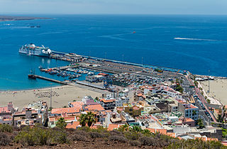
The Port of Los Cristianos is a port of the Atlantic Ocean located in the town of Los Cristianos, in the municipality of Arona on the island of Tenerife. It is administered by the Port Authority of Santa Cruz de Tenerife. It is the port with the highest passenger and vehicle traffic in the Canary Islands, in 2007 it had 1,829,579 passengers, and 238,836 vehicles.

