
Catalonia is an autonomous community in the northeastern corner of Spain, designated as a nationality by its Statute of Autonomy.

Garrotxa is a comarca (county) in Girona, Catalonia, Spain. Its population in 2016 was 55,999, more than half of them in the capital city of Olot. It is roughly equivalent to the historical County of Besalú.
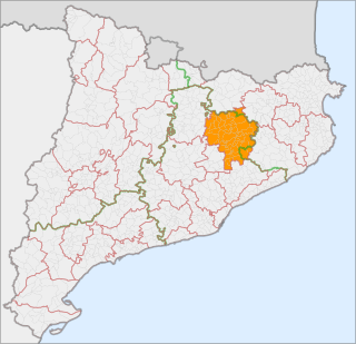
Osona is a comarca situated in Catalonia, Northeast Spain. Its capital is Vic. Its population in 2001 was 129,543. Osona covers roughly the same area as the historic Catalan county of Osona. The name Osona comes from Ausetans, a group of Iberian people who had their capital in Ausa ; the Romans called the area Ausone or Ausona. While most of the comarca is within the province of Barcelona, the municipalities of Espinelves, Vidrà and Viladrau form part of the province of Girona
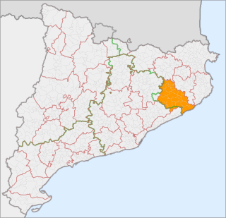
Selva is a coastal comarque (county) in Catalonia, Spain, located between the mountain range known as the Serralada Transversal or Puigsacalm and the Costa Brava. Unusually, it is divided between the provinces of Girona and Barcelona, with Fogars de la Selva being part of Barcelona province and all other municipalities falling inside Girona province. Also unusually, its capital, Santa Coloma de Farners, is no longer among its larger municipalities, with the coastal towns of Blanes and Lloret de Mar having far surpassed it in size.

Cornudella de Montsant is a municipality in the comarca of the Priorat in Catalonia, Spain. It is situated in the north-west of the comarca below the Montsant range and the Prades Mountains. The Siurana reservoir is on the territory of the municipality and supplies its drinking water.
Santa Maragarida de Montbui is a municipality in the comarca of the Anoia in Catalonia, Spain. It is situated in the Òdena Basin, immediately to the west of Igualada of which it effectively forms a suburb. The ajuntament is in Sant Maure. Other neighbourhoods in Montbui are the Old Town, el Saió-Coll del Guix and La Mallola.
La Guingueta d'Àneu is a municipality in the comarca of the Pallars Sobirà in Catalonia, Spain. It is situated in the valley of the Noguera Pallaresa river below the reservoir of La Torrassa. It is linked to Sort by the C-147 road.

Vilanova de Sau is a town in the comarca of the Osona in Catalonia, eastern Spain. It is situated in the valley called Sau. The Ter river runs through the valley, now damed into Pantà de Sau, a reservoir which is in the municipal territory of Vilanova de Sau, and is a tourist attraction and base for water sports and hiking. The reservoir houses the submerged village of church of Sant Romà.

C-25 or Eix Transversal is a 280 km long primary highway in Catalonia, Spain. It crosses the Catalan Transversal Range mountainous region, connecting the northern end of the Catalan Coastal Depression with the Catalan Central Depression.

Porqueres is a municipality located in the county of Pla de l'Estany, in the province of Girona, in the autonomous region of Catalunya of Spain. The municipality is made up of several villages. Mata, Les Pedreres and Miànigues, have the largest part of the population. At the top of the mountain range of Serra de Sant Patllari is the village of Pujarnol. In the west is Porqueres, and on the northern part of the Lake of Banyoles is Usall. Amid the green forests of the Ginestar mountains is the village of Merlant.

The Barcelona orbital line is a railway project forming part of both the Pla d'infraestructures de Catalunya (PITC), a long-term development plan due for completion in 2026, and the Pla de transport de viatgers de Catalunya (PTVC), a short-term plan due for completion in 2012. In following perimeter routes the orbital line and another railway project, the Eix Transversal Ferroviari de Catalunya, are the first railway schemes to depart from the radial system developed so far in the Barcelona area.

Sant Miquel de Solterra or Sant Miquel de les Formigues is the highest mountain of the Guilleries Massif, Catalonia, Spain. It has an elevation of 1,201.9 metres above sea level.

Sant Roc, also known as Sant Roc d'Amer, Sant Roc de la Barroca and Grony, is a mountain of the Catalan Transversal Range, Catalonia, Spain. It has an elevation of 591 metres above sea level. It is part of the range that separates the Llémena River and the Brugent river valleys and is located at the confluence of the Garrotxa, el Gironès and la Selva comarques. This mountain has a striking appearance and is quite visible from the road between Bonmatí and Sant Martí de Llémena. The steep cliffs on the southern and northeastern sides of the mountain are known as Cingles de Sant Roc.

Serra de Montsant is a mountain chain in Catalonia, Spain. The main populated area in the range is La Morera de Montsant.

The Catalan Transversal Range is a system of minor mountain ranges at the eastern end of the Pre-Pyrenees, between the Osona and Garrotxa comarques. The existence of the Catalan Transversal Range has made communications in the northern areas of Catalonia difficult in the past, especially between Northeastern Catalonia and Western Catalonia, a problem that has been partly solved with the development of the Eix Transversal.
The Catalan Mediterranean System, also known as Mediterranean System, Transversal Ibero-Pyrenaean System, and Catalanid System, is a wide coastal geographical region in Catalonia. It is made up of a double system of coastal mountain chains: The Catalan Coastal Range and the Catalan Pre-Coastal Range, as well as the Catalan Coastal Depression and other coastal and pre-coastal plains located among those mountain ranges.
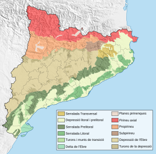
The Sub-Pyrenees are a mountainous region in Catalonia, Spain, forming a section of the southern foothills of the Pyrenees. They are located at the eastern end of the Pre-Pyrenees, west of the Catalan Transversal Range, between the lower Ripollès and an area of the high Garrotxa.

Serra de Llaberia is a mountain chain in Catalonia, Spain located between the Prades and the Tivissa-Vandellòs Mountains.
Republican Left of Catalonia–Catalonia Yes is a Catalan pro-independence electoral alliance. The alliance is formed by Republican Left of Catalonia, Catalonia Yes and independents, and in the 2015 and 2016 Spanish general elections it was led by Gabriel Rufián.
The Catalan Space Agency is a project approved by the Executive Council of the Generalitat de Catalunya on October 27, 2020, and which aims to launch two nanosatellites in the first half of the year 2021. The project, with an initial duration of two years until 2023, envisages the launch of a constellation of up to six satellites with a public investment of 21 million dollars over four years with part of the co-financing from the European Regional Development Fund. The project would be led by the Ministry of Digital Policies, the Department of Business, and the Department of Territory, and would be part of the plan called "NewSpace Strategy of Catalonia" or "Estratègia NewSpace de Catalunya".
