Related Research Articles

The Coast Mountains are a major mountain range in the Pacific Coast Ranges of western North America, extending from southwestern Yukon through the Alaska Panhandle and virtually all of the Coast of British Columbia south to the Fraser River. The mountain range's name derives from its proximity to the sea coast, and it is often referred to as the Coast Range. The range includes volcanic and non-volcanic mountains and the extensive ice fields of the Pacific and Boundary Ranges, and the northern end of the volcanic system known as the Cascade Volcanoes. The Coast Mountains are part of a larger mountain system called the Pacific Coast Ranges or the Pacific Mountain System, which includes the Cascade Range, the Insular Mountains, the Olympic Mountains, the Oregon Coast Range, the California Coast Ranges, the Saint Elias Mountains and the Chugach Mountains. The Coast Mountains are also part of the American Cordillera—a Spanish term for an extensive chain of mountain ranges—that consists of an almost continuous sequence of mountain ranges that form the western backbone of North America, Central America, South America and Antarctica.

The Transverse Ranges are a group of mountain ranges of southern California, in the Pacific Coast Ranges physiographic region in North America. The Transverse Ranges begin at the southern end of the California Coast Ranges and lie within Santa Barbara, Ventura, Los Angeles, San Bernardino, Riverside and Kern counties. The Peninsular Ranges lie to the south. The name Transverse Ranges is due to their east–west orientation, making them transverse to the general northwest–southeast orientation of most of California's coastal mountains.

Blueschist, also called glaucophane schist, is a metavolcanic rock that forms by the metamorphism of basalt and rocks with similar composition at high pressures and low temperatures, approximately corresponding to a depth of 15–30 km (9.3–18.6 mi). The blue color of the rock comes from the presence of the predominant minerals glaucophane and lawsonite.
In geology, basement and crystalline basement are the rocks below a sedimentary platform or cover, or more generally any rock below sedimentary rocks or sedimentary basins that are metamorphic or igneous in origin. In the same way, the sediments or sedimentary rocks on top of the basement can be called a "cover" or "sedimentary cover".
The Franciscan Complex or Franciscan Assemblage is a geologic term for a late Mesozoic terrane of heterogeneous rocks found throughout the California Coast Ranges, and particularly on the San Francisco Peninsula. It was named by geologist Andrew Lawson, who also named the San Andreas fault that defines the western extent of the assemblage.

The geology of the Rocky Mountains is that of a discontinuous series of mountain ranges with distinct geological origins. Collectively these make up the Rocky Mountains, a mountain system that stretches from Northern British Columbia through central New Mexico and which is part of the great mountain system known as the North American Cordillera.

An accretionary wedge or accretionary prism forms from sediments accreted onto the non-subducting tectonic plate at a convergent plate boundary. Most of the material in the accretionary wedge consists of marine sediments scraped off from the downgoing slab of oceanic crust, but in some cases the wedge includes the erosional products of volcanic island arcs formed on the overriding plate.

The Coast Range Arc was a large volcanic arc system, extending from northern Washington through British Columbia and the Alaska Panhandle to southwestern Yukon. The Coast Range Arc lies along the western margin of the North American Plate in the Pacific Northwest of western North America. Although taking its name from the Coast Mountains, this term is a geologic grouping rather than a geographic one, and the Coast Range Arc extended south into the High Cascades of the Cascade Range, past the Fraser River which is the northward limit of the Cascade Range proper.

Ring Mountain is an elevated landform on the Tiburon Peninsula in Marin County, California. This mountain was named for George E. Ring, who served as a Marin County Supervisor from 1895 to 1903.
This is a list of articles related to plate tectonics and tectonic plates.

The Western Carpathians are an arc-shaped mountain range, the northern branch of the Alpine-Himalayan fold and thrust system called the Alpide belt, which evolved during the Alpine orogeny. In particular, their pre-Cenozoic evolution is very similar to that of the Eastern Alps, and they constitute a transition between the Eastern Alps and the Eastern Carpathians.

Huangling Complex represents a group of rock units appear in the middle of Yangtze Block in South China, distributed across Yixingshan, Zigui, Huangling and Yichang counties. The group of rock involves nonconformity that sedimentary rocks overlie the metamorphic basement. It is a 73-km long, asymmetrical dome-shaped anticline with axial plane orientating in north-south direction. It has a steeper west flank and a gentler east flank. Basically, there are three tectonic units from the anticline core to the rim, including Archean to Paleoproterozoic metamorphic basement, Neoproterozoic to Jurassic sedimentary rocks and Cretaceous fluvial deposit sedimentary cover. The northern part of the core is mainly tonalite-trondhjemite-gneiss (TTG) and Cretaceous sedimentary rock, it is called the Archean Kongling Complex. The middle of the core is mainly the Neoproterozoic granitoid. The southern part of the core is the Neoproterozoic potassium granite. Two basins are situated on the western and eastern flanks of the core respectively, including the Zigui basin and Dangyang basin. Both basins are synforms while Zigui basin has a larger extent of folding. Yuanan Graben and Jingmen Graben are found within Dangyang Basin area. Huangling Complex is an important area that helps unravel the tectonic history of South China Craton because it has well-exposed layers of rock units from Archean basement rock to Cretaceous sedimentary rock cover due to the erosion of the anticline.
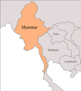
The geology of Myanmar is shaped by dramatic, ongoing tectonic processes controlled by shifting tectonic components as the Indian plate slides northwards and towards Southeast Asia. Myanmar spans across parts of three tectonic plates separated by north-trending faults. To the west, a highly oblique subduction zone separates the offshore Indian plate from the Burma microplate, which underlies most of the country. In the center-east of Myanmar, a right lateral strike slip fault extends from south to north across more than 1,000 km (620 mi). These tectonic zones are responsible for large earthquakes in the region. The India-Eurasia plate collision which initiated in the Eocene provides the last geological pieces of Myanmar, and thus Myanmar preserves a more extensive Cenozoic geological record as compared to records of the Mesozoic and Paleozoic eras. Myanmar is physiographically divided into three regions: the Indo-Burman Range, Myanmar Central Belt and the Shan Plateau; these all display an arcuate shape bulging westwards. The varying regional tectonic settings of Myanmar not only give rise to disparate regional features, but they also foster the formation of petroleum basins and a diverse mix of mineral resources.

The geology of Somaliland is very closely related to the geology of Somalia. Somaliland is a de facto independent country within the boundaries that the international community recognizes as Somalia. Because it encompasses the former territory of British Somaliland, the region is historically better researched than former Italian Somaliland. Somaliland is built on more than 700 million year old igneous and metamorphic crystalline basement rock.. These ancient units are covered in thick layers of sedimentary rock formed in the last 200 million years and influenced by the rifting apart of the Somali Plate and the Arabian Plate.
The geology of Nigeria formed beginning in the Archean and Proterozoic eons of the Precambrian. The country forms the Nigerian Province and more than half of its surface is igneous and metamorphic crystalline basement rock from the Precambrian. Between 2.9 billion and 500 million years ago, Nigeria was affected by three major orogeny mountain-building events and related igneous intrusions. Following the Pan-African orogeny, in the Cambrian at the time that multi-cellular life proliferated, Nigeria began to experience regional sedimentation and witnessed new igneous intrusions. By the Cretaceous period of the late Mesozoic, massive sedimentation was underway in different basins, due to a large marine transgression. By the Eocene, in the Cenozoic, the region returned to terrestrial conditions.
The geology of Alaska includes Precambrian igneous and metamorphic rocks formed in offshore terranes and added to the western margin of North America from the Paleozoic through modern times. The region was submerged for much of the Paleozoic and Mesozoic and formed extensive oil and gas reserves due to tectonic activity in the Arctic Ocean. Alaska was largely ice free during the Pleistocene, allowing humans to migrate into the Americas.
The geology of Thailand includes deep crystalline metamorphic basement rocks, overlain by extensive sandstone, limestone, turbidites and some volcanic rocks. The region experienced complicated tectonics during the Paleozoic, long-running shallow water conditions and then renewed uplift and erosion in the past several million years ago.
The geology of Venezuela includes ancient Precambrian igneous and metamorphic basement rocks, layered with sedimentary rocks from the Paleozoic and Mesozoic and thick geologically recent Cenozoic sediments with extensive oil and gas.
The geology of Ecuador includes ancient Precambrian basement rock and a complex tectonic assembly of new sections of crust from formerly separate landmasses, often uplifted as the Andes or transformed into basins.
The geology of California is highly complex, with numerous mountain ranges, substantial faulting and tectonic activity, rich natural resources and a history of both ancient and comparatively recent intense geological activity. The area formed as a series of small island arcs, deep-ocean sediments and mafic oceanic crust accreted to the western edge of North America, producing a series of deep basins and high mountain ranges.
References
- ↑ Rowland, Stephan M., Geology of Santa Catalina Island, California Geology, 1984 "Archived copy" (PDF). Archived from the original (PDF) on 2012-10-29. Retrieved 2011-10-30.
{{cite web}}: CS1 maint: archived copy as title (link)
Coordinates: 33°24′14″N118°22′41″W / 33.404°N 118.378°W
| | This article about a specific United States geological feature is a stub. You can help Wikipedia by expanding it. |