Kingston is a town on the outskirts of Hobart, Tasmania, Australia. Nestled 12 km south of the city between and around several hills, Kingston is the seat of the Kingborough Council, and today serves as the gateway between Hobart and the D'Entrecasteaux Channel region, which meets the Derwent River nearby. It is one of the fastest-growing regions in Tasmania. The Kingston-Huntingfield statistical area had an estimated population of 11,200 in June 2012.
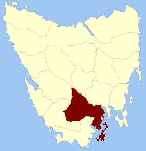
Kingborough Council is a local government body in Tasmania, and one of the five municipalities that constitutes the Greater Hobart Area. Kingborough is classified as an urban local government area and has a population of 37,734, it covers the transition from the southern urban areas of Hobart through Kingston, as well as encompassing Bruny Island.

Rosny is a suburb of the City of Clarence, part of the greater Hobart area, Tasmania, Australia. It is located on the eastern shore of the Derwent River, between the suburbs of Montagu Bay and Rosny Park, approximately 4 kilometres from Hobart's centre. Rosny is the residential part of its commercial namesake Rosny Park.
Fern Tree is a rural / residential locality in the local government areas (LGA) of Hobart (64%) and Kingborough (36%) in the Hobart LGA region of Tasmania. The locality is about 9 kilometres (5.6 mi) south-west of the town of Hobart. The 2016 census recorded a population of 726 for the state suburb of Fern Tree.

Woodbridge is a semi-rural locality in the local government area (LGA) of Kingborough in the Hobart LGA region of Tasmania. The locality is about 26 kilometres (16 mi) south of the town of Kingston. The 2016 census has a population of 503 for the state suburb of Woodbridge. It is located 38 kilometres (24 mi) south of the state capital, Hobart.

Narcissus Hut is an alpine hut located in the Central Highlands of Tasmania. It was first built in 1935 and rebuilt in 1963 after being burnt down. The hut was renovated in 2015, when a new sheltered deck was constructed on the eastern side, along with paintwork.
Neika is a rural locality in the local government areas (LGA) of Hobart and Kingborough in the Hobart LGA region of Tasmania. The locality is about 20 kilometres (12 mi) south-west of the city of Hobart. The 2016 census recorded a population of 198 for the state suburb of Neika. It is a suburb of Hobart, to the north-west of Kingston.

The Anglican Diocese of Tasmania includes the entire Tasmanian archipelago and is an extraprovincial diocese of the Anglican Church of Australia.

Kingston Beach is a residential locality in the local government area (LGA) of Kingborough in the Hobart LGA region of Tasmania. The locality is about 2 kilometres (1.2 mi) south-east of the town of Kingston. The 2016 census recorded a population of 1990 for the state suburb of Kingston Beach.
Huntingfield is a residential locality in the local government area (LGA) of Kingborough in the Hobart LGA region of Tasmania. The locality is about 3 kilometres (1.9 mi) south-west of the town of Kingston. The 2016 census recorded a population of 428 for the state suburb of Huntingfield.
Barnes Bay is a rural locality on Bruny Island in the local government area (LGA) of Kingborough in the Hobart LGA region of Tasmania. The locality is about 35 kilometres (22 mi) south of the town of Kingston. The 2016 census recorded a population of 22 for the state suburb of Barnes Bay.
Buckingham Land District is one of the twenty land districts of Tasmania which are part of the Lands administrative divisions of Tasmania. It was formerly Buckingham County, one of the 18 counties of Tasmania and one of the first eleven proclaimed in 1836 and is bordered to the north by the River Derwent, and to the south by the Huon River. It includes Bruny Island. Hobart is located in the county. It was named after the then county of England.
David Edward Leaman was an author, structural geologist, geohydrologist and geophysicist.

Smooth Island, is a privately owned island with an area of 59.31 ha lying close to the south-eastern coast of Tasmania, Australia. The island is part of the Sloping Island Group situated in Norfolk Bay and surrounded by the Tasman and Forestier Peninsulas. The towns Dunalley and Murdunna are nearby. Smooth Island differs from other Tasmanian islands as it has an unencumbered freehold title down to the high-water mark.
Pelverata is a rural locality in the local government areas (LGA) of Huon Valley and Kingborough in the South-east and Hobart LGA regions of Tasmania. The locality is about 22 kilometres (14 mi) south-west of the town of Kingston. The 2016 census recorded a population of 206 for the state suburb of Pelverata. It is a town in Tasmania, Australia, to the east of Huonville. It is mainly in the Huon Valley Council area, with about 4% in the Kingborough Council LGA.
Alan Cameron Walker (1865–1931) was an Australian architect and philanthropist, born in Hobart, Tasmania. The grandson of John Walker, he was educated at Hutchins School and apprenticed to Henry Hunter. He produced many Tasmanian government and other buildings during his career, and was also a keen silversmith, serving as President of the Tasmanian Arts and Crafts Society for 25 years. He was the first President of the Tasmanian Architect's Registration Board.

Isle of the Dead is an island, about 1 hectare in area, adjacent to Port Arthur, Tasmania, Australia. It is historically significant since it retains an Aboriginal coastal shell midden, one of the first recorded sea-level benchmarks, and one of the few preserved Australian convict-period burial grounds. The Isle of the Dead occupies part of the Port Arthur Historic Site, is part of Australian Convict Sites and is listed as a World Heritage Property because it represents convictism in the era of British colonisation.
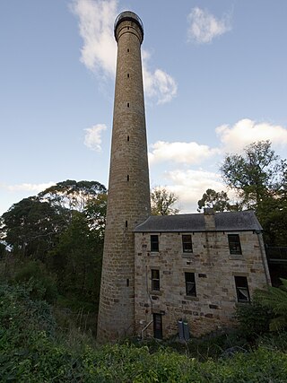
The Shot Tower at Taroona is a heritage listed historic building between Hobart and Kingston, Tasmania. It was the tallest building in Australia for four years (1870-1875), and the tallest structure in Tasmania until it was superseded by the Mount Wellington broadcast tower in 1960. The Taroona Shot Tower is believed to be the tallest circular sandstone tower in the world.

Wellington Park is the protected area which encompasses kunanyi / Mount Wellington and surrounds near Hobart, Tasmania. There are numerous hiking and mountain bike tracks within the park of varying difficulty.
Wellington Park is a rural locality in the local government areas of Derwent Valley, Hobart, Glenorchy, Huon Valley, and Kingborough in the South-east and Hobart regions of Tasmania. It is located about 20 kilometres (12 mi) west of the Hobart CBD. The 2016 census determined a population of nil for the state suburb of Wellington Park.
