Caucagua

Last updated
Caucagua
Cancha de Bolas Criollas..jpg
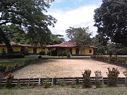
Colonial Architecture in Caucagua, Municipality of Acevedo
Bandera Acevedo Miranda.PNG
Venezuela location map (+claimed).svg
Red pog.svg
Caucagua
Coordinates: 10°16′56″N66°22′38″W / 10.28222°N 66.37722°W / 10.28222; -66.37722
Country Flag of Venezuela.svg Venezuela
State Miranda
Municipality Acevedo Municipality
Elevation
280 m (920 ft)
Population
 (2001)
  Total35,000
   Demonym
Caucagüeño/a
Time zone VST
Postal code
1246
Climate Am

Caucagua is a Venezuelan city in the state of Miranda, and is the capital of the Acevedo Municipality.

The town of later Caucagua was founded as Valle de Araguata in about 1690. It was refounded with the name of Caucagua in 1752. Bishop Mariano Martí gave it the name Nuestra Señora del Valle de la Santa Cruz de Caucagua in 1784. The population in 1783 was 2,422. [1]

During the 2000 census, the population was estimated to be around 35,000. In comparison with neighboring towns, Caucagua enjoys a fairly strong economic activity thanks to its location at the crossroads between Caracas, the east of Venezuela, and the rest of the Miranda state. The city is also an agricultural nucleus, mainly due to its production of cacao in the bordering areas.

Related Research Articles

<span class="mw-page-title-main">Caracas</span> Capital and largest city of Venezuela

Caracas, officially Santiago de León de Caracas, abbreviated as CCS, is the capital and largest city of Venezuela, and the center of the Metropolitan Region of Caracas. Caracas is located along the Guaire River in the northern part of the country, within the Caracas Valley of the Venezuelan coastal mountain range. The valley is close to the Caribbean Sea, separated from the coast by a steep 2,200-meter-high (7,200 ft) mountain range, Cerro El Ávila; to the south there are more hills and mountains. The Metropolitan Region of Caracas has an estimated population of almost 5 million inhabitants.

<span class="mw-page-title-main">Aragua</span> State of Venezuela

Aragua State is one of the 23 states of Venezuela. It is located in the north-central region of Venezuela. It has plains and jungles and Caribbean beaches. The most popular are Cata and Choroni. It has Venezuela's first national park which is called Henri Pittier. The capital is Maracay, other important cities include Turmero and El Limón.

The project of the Pan-American highway began approximately in or before 1923. The main idea was to create a network of wide roads that would connect major points of interest in North and South America with a single highway.

<span class="mw-page-title-main">Guárico</span> State of Venezuela

Guárico State is one of the 23 states of Venezuela. The state capital is San Juan de Los Morros. Guárico State covers a total surface area of 64,986 km2 (25,091 sq mi) and, in 2011, had a census population of 747,739. It is named for the Guárico River.

<span class="mw-page-title-main">Miranda (state)</span> State of Venezuela

Miranda State is one of the 23 states of Venezuela and the second most populous after Zulia State. As of the 2011 census, it had a population of 2,675,165 residents. It also has the greatest Human Development Index in Venezuela, according to the Venezuelan National Institute of Statistics. The most recent population estimate was 3,194,390 in mid-2016.

<span class="mw-page-title-main">Vargas (state)</span> State of Venezuela

La Guaira State, officially La Guaira, and known until 2019 as Vargas State is one of the 23 states of Venezuela. Formerly named after Venezuela's first civilian president, José María Vargas, Vargas comprises a coastal region in the north of Venezuela, bordering Aragua to the west, Miranda to the east, the Caribbean Sea to the north and the Capital District to the south. It is home to both the country's largest seaport and airport. The state capital is La Guaira. The Litoral Varguense conurbation is the principal urban agglomeration in the state, which is part of the Greater Caracas Area.

<span class="mw-page-title-main">Apure River</span> River in Colombia, Venezuela

The Apure River is a river of southwestern Venezuela, formed by the confluence of the Sarare and Uribante near Guasdualito, in Venezuela, at 7°15′N70°40′W, and flowing across the Llanos into the Orinoco. It provides significant transportation in the area.

<span class="mw-page-title-main">Chacao Municipality</span> Municipality in Miranda, Venezuela

Chacao is one of the five political and administrative subdivisions of the city of Caracas, Venezuela. The other four are Baruta, El Hatillo, Libertador and Sucre. This legal entity is known as the Caracas Metropolitan District. Chacao is also one of the 21 municipalities that make up the State of Miranda, Venezuela.

<span class="mw-page-title-main">Valle de la Pascua</span> Place in Guárico, Venezuela

Valle de la Pascua is the capital city of the autonomous municipality of Leonardo Infante, Guárico, Venezuela. The city is located in the central plains of Venezuela and was founded on February 25, 1785, by Father Mariano Martí. Along with Zaraza, Calabozo and San Juan de Los Morros, Valle de la Pascua is one of the most important cities in the state of Guárico and the most important economically. The vicinity of the city was the scene of the Battle of Valle de la Pascua in February 1814.

<span class="mw-page-title-main">Municipalities of Venezuela</span> Subdivisions of the States of Venezuela

Municipalities of Venezuela are subdivisions of the States of Venezuela. There are 335 municipalities dividing the 23 states and the Capital District.

<span class="mw-page-title-main">El Hatillo Municipality</span> Municipality in Miranda, Venezuela

El Hatillo Municipality is an administrative division of the State of Miranda, Venezuela; along with Baruta, Chacao, Libertador and Sucre, it is one of the five municipalities of Caracas, the capital of Venezuela. It is located in the southeastern area of Caracas, and in the northwestern part of the State of Miranda.

<span class="mw-page-title-main">Zamora Municipality, Miranda</span> Municipality in Miranda, Venezuela

Zamora is one of the 21 municipalities (municipios) that makes up the Venezuelan state of Miranda and, according to a 2016 population estimate by the National Institute of Statistics of Venezuela, the municipality has a population of 218,911. The town of Guatire is the municipal seat of the Zamora Municipality.

<span class="mw-page-title-main">Petare</span> Place in Miranda, Venezuela

<span class="mw-page-title-main">Charallave</span> Place in Miranda, Venezuela

Charallave is a city in the state of Miranda, Venezuela, and part of Miranda's Valles del Tuy region. It is the capital of Cristóbal Rojas Municipality. The name derives from the local Charavares indigenous people found at the time the city was founded.

The Tuy River is a river of northern Venezuela, in the Valles del Tuy of Miranda State. The principal river of Miranda, it flows north from Aragua State through Miranda into the Caribbean Sea. Tributaries include the Guaire River, the principal river of Caracas, and the Caucagua River.

<span class="mw-page-title-main">Valles del Tuy metropolitan area</span> Conurbation in Miranda ----, Venezuela

The Valles del Tuy metropolitan area is a metropolitan area in Miranda, Venezuela, that includes six municipalities, and is part of the Greater Caracas Area. It had a population of 811,166 inhabitants in 2016.

<span class="mw-page-title-main">Barlovento, Venezuela</span>

Barlovento is a sub-region of Miranda state, Venezuela. During Spanish colonization of the Americas, Barlovento was developed as estate owners founded cacao haciendas. The work on the estates was done by African slaves brought from what is now the Republic of the Congo, Democratic Republic of the Congo and Angola. These people were from the Kingdom of Kongo and Kingdom of Loango. There were also Yoruba slaves.

The 1900 Venezuelan earthquake, occurred on October 28 at between 4:30 and 4:45 am local time. This earthquake had an epicenter off Miranda State or near the Venezuelan capital Caracas, in the Cariaco Basin. It had an estimated moment magnitude of 7.6–7.7 and a surface-wave magnitude of 7.7–8.4. It had a maximum Mercalli intensity assigned VIII–X, causing landslides and liquefaction events. Many buildings were severely damaged or collapsed during the earthquake. It is thought to be the last great earthquake of the 19th century and the largest instrumentally recorded in the republic, having been felt throughout.

<span class="mw-page-title-main">Constitution of Venezuela (1811)</span> First constitution of Venezuela

The Constitution of Venezuela of 1811 was the first Constitution of Venezuela and Ibero-America, promulgated and written by Cristóbal Mendoza and Juan Germán Roscio, being sanctioned by the Constituent Congress of 1811 in the city of Caracas on December 21, 1811. It was overthrown on July 21, 1812 by the capitulation of Francisco de Miranda in San Mateo. The constitution was in force for exactly seven months.

References

  1. (in Spanish) Jose Marcial Ramos Guedez Historia del Estado Miranda, Ediciones de la Presidencia de la República, Caracas, Venezuela, 1980.