Related Research Articles

Catron County is a county in the U.S. state of New Mexico. As of the 2020 census, the population was 3,579, making it New Mexico's third-least populous county. Its county seat is Reserve. Catron County is New Mexico's largest county by area.

Oscarville is a census-designated place (CDP) in Bethel Census Area, Alaska, United States. The population was 70 at the 2010 census, up from 61 in 2000.

Oracle is a census-designated place (CDP) in Pinal County, Arizona, United States. The population was 3,686 at the 2010 Census, falling to 3,051 at the 2020 Census.

Santa Clara is a town in Franklin County, New York, United States. The population was 332 at the 2020 census, down from 345 at the 2010 census. The name was derived from the wife of an early town businessman, John Hurd.

A sinkhole is a depression or hole in the ground caused by some form of collapse of the surface layer. The term is sometimes used to refer to doline, enclosed depressions that are also known as shakeholes, and to openings where surface water enters into underground passages known as ponor, swallow hole or swallet. A cenote is a type of sinkhole that exposes groundwater underneath. Sink, and stream sink are more general terms for sites that drain surface water, possibly by infiltration into sediment or crumbled rock.

The Escalante River is a tributary of the Colorado River. It is formed by the confluence of Upper Valley and Birch Creeks near the town of Escalante in south-central Utah, and from there flows southeast for approximately 90 mi (140 km) before joining Lake Powell. Its watershed includes the high forested slopes of the Aquarius Plateau, the east slope of the Kaiparowits Plateau, and the high desert north of Lake Powell. It was the last river of its size to be discovered in the 48 contiguous U.S. states. The average discharge is approximately 146 cfs.

North central Florida is a region of the U.S. state of Florida which comprises the north-central part of the state and encompasses the north Florida counties of Alachua, Marion, Putnam, Bradford, Columbia, Dixie, Gilchrist, Hamilton, Lafayette, Levy, Madison, Suwannee, Taylor, and Union. The region's largest city is Gainesville, home of the University of Florida and center of the Gainesville metropolitan area, which is the largest metro area of the region. As of 2020, the region had a population of 575,622 people.

The Rincon Mountains are a significant mountain range east of Tucson, Pima County, Arizona, in the United States. The Rincon Mountains are one of five mountain ranges surrounding the Tucson valley. The other ranges include the most prominent, the Santa Catalina Mountains to the north, the Santa Rita Mountains to the south, the Tucson Mountains to the west, and the Tortolita Mountains to the northwest. Redington Pass separates the Rincon Mountains from the Santa Catalina Mountains. The Rincon Mountains are generally less rugged than the Santa Catalina Mountains and Santa Rita Mountains. The Rincon Mountains are also included in the Madrean sky island mountain ranges of southeast Arizona, extreme southwest New Mexico, and northern Sonora Mexico.

Hole-in-the-Ground is a large maar in the Fort Rock–Christmas Lake Valley basin of Lake County, central Oregon, northeast of Crater Lake, near Oregon Route 31.
The Rio Chama, a major tributary river of the Rio Grande, is located in the U.S. states of Colorado and New Mexico. The river is about 130 miles (210 km) long altogether. From its source to El Vado Dam its length is about 50 miles (80 km), from El Vado Dam to Abiquiu Dam is about 51 miles (82 km), and from Abiquiu Dam to its confluence with the Rio Grande is about 34 miles (55 km).

Peppersauce Cave is a limestone cave found in the Santa Catalina Mountains approximately ten miles south of Oracle, Arizona. Peppersauce is frequented by about 23,000 visitors every year and contains approximately one mile of mapped passages.
Santa Cruz is a town in Santa Cruz Municipality, in the northern region of the Mexican state of Sonora.

An underground lake is a lake underneath the surface of the Earth. Most naturally occurring underground lakes are found in areas of karst topography, where limestone or other soluble rock has been weathered away, leaving a cave where water can flow and accumulate.
Badger Pot and Pigeon Pot are two caves found in the Karst topography on the eastern slopes of Cuilcagh Mountain, south of Florencecourt Forest Park, County Fermanagh, Northern Ireland.

Dragoon National Forest was established in Arizona on May 25, 1907, covering 69,120 acres (280 km2). On July 1, 1908, it was combined with Santa Catalina National Forest and Santa Rita National Forest to create Coronado National Forest. The name was discontinued.
Santa Catalina National Forest was established as the Santa Catalina Forest Reserve by the United States General Land Office in Arizona on July 2, 1902 with 155,520 acres (629.4 km2). After the transfer of federal forests to the U.S. Forest Service in 1905, it became a National Forest on March 4, 1907. On July 1, 1908 it was combined with Dragoon National Forest and Santa Rita National Forest to create Coronado National Forest and the name was discontinued.
Santa Rita National Forest was established as the Santa Rita Forest Reserve by the United States General Land Office in Arizona on April 11, 1902 with 337,300 acres (1,365 km2). After the transfer of federal forests to the U.S. Forest Service in 1905, it became a National Forest on March 4, 1907. On July 1, 1908 it was combined with Santa Catalina National Forest and Dragoon National Forest to create Coronado National Forest and the name was discontinued.
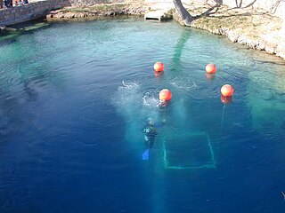
The Blue Hole of Santa Rosa, or simply the Blue Hole, is a circular, bell-shaped pool or small lake located along Route 66 east of Santa Rosa, New Mexico that is a tourist attraction and swimming venue, and one of the most popular dive destinations in the US for scuba diving and training. The Blue Hole is an artesian well and cenote that was once used as a fish hatchery.
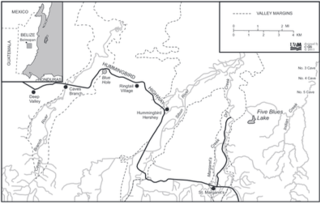
Five Blues Lake National Park is a 10-acre parcel of tropical forest in Belize, which is enclosed by over 4,000 acres of limestone hills. The lake obtained its name from the different shades of blue it reflects from the different water depths and the reflection of sunlight through the trees that frame the lake. The lake is maintained by an Association of Friends living in the Village of St. Margret's, a few minutes from the lakeside. Beside the lake is a shoreline of sunken limestone at the edge of the lake which leads to Orchid Island, where an abundance of wild orchids grows. In 2007, a drought was thought to have condemned the lake; studies were conducted to determine the cause.
References
31°43′44″N110°46′06″W / 31.72892°N 110.76844°W
| | This Santa Cruz County, Arizona location article is a stub. You can help Wikipedia by expanding it. |
| | This article about a cave in the United States is a stub. You can help Wikipedia by expanding it. |