Related Research Articles

The Pelotas River is a river in southern Brazil, and a tributary of the Uruguay River.

Lages is a Brazilian municipality located in the central part of the state of Santa Catarina, in the region known in Portuguese as "Planalto Serrano".
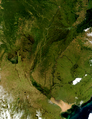
The Río de la Plata basin, more often called the River Plate basin in scholarly writings, sometimes called the Platine basin or Platine region, is the 3,170,000-square-kilometre (1,220,000 sq mi) hydrographical area in South America that drains to the Río de la Plata. It includes areas of southeastern Bolivia, southern and central Brazil, the entire country of Paraguay, most of Uruguay, and northern Argentina. Making up about one fourth of the continent's surface, it is the second largest drainage basin in South America and one of the largest in the world.

Tubarão is a Brazilian municipality located in southern part of Santa Catarina state. The population, according to the IBGE/2020 estimate was 106,422. It is the main city of the Tubarão River basin region, which comprises 20 municipalities and has a population of 350,000.

Urubici is a southern Brazilian municipality located in the state of Santa Catarina.

São Joaquim National Park is a National park in the state of Santa Catarina, Brazil.

Campos Novos is a city in Santa Catarina, in the Southern Region of Brazil. Campos Novos is a pioneer in production of pollen and the biggest grain and oat producer of Santa Catarina. The municipality invests also into fat stock and poultry farming.
The Leão River is a river of Santa Catarina state in southeastern Brazil. It is a tributary of Canoas or Sertão branch river.
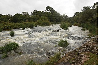
The Canoas River is a river of Santa Catarina state in southeastern Brazil. With a length of 570 kilometres, the river joins the Pelotas River to form the Uruguay River.
The São João River is a tributary of the Canoas River in Santa Catarina state, southeastern Brazil. It is a tributary of the Inferno Grande River, part of the Uruguay River basin.
The Inferno Grande River is a river of Santa Catarina state in southeastern Brazil. It is a tributary of the Canoas River, part of the Uruguay River basin.

The Marombas River is a river of Santa Catarina state in southeastern Brazil. It is a tributary of the Canoas River and part of the Uruguay River basin.
The Dos Indios River is a river of Santa Catarina state in southeastern Brazil. It is part of the Uruguay River basin and is a tributary of the Canoas River.
Dos Indios River or Rio dos Indios may refer to:
São José do Cerrito is a municipality in the state of Santa Catarina in the South region of Brazil. It was created in 1961 out of the existing municipality of Lages.
Correia Pinto is a municipality in the state of Santa Catarina in the South region of Brazil. It was created in 1982 out of the existing municipality of Lages.
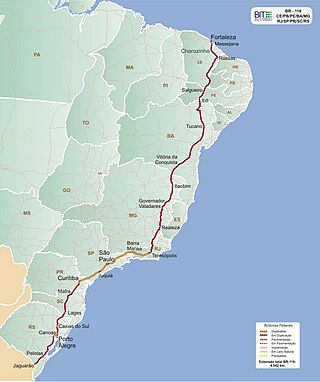
BR-116 is a federal route of highways of Brazil and the longest highway in the country, with 4,542 km (2,822 mi) of extension. The road connect Fortaleza, Ceará, one of the largest Northeast Brazil metropolises, to the southern city of Jaguarão, Rio Grande do Sul, in the border with Uruguay. It is also the longest highway in the country to be completely paved. It is considered one of the most important highways in the country, along with BR-101.
The Canoas River, also known as Sertão River, is a river of Santa Catarina state in southeastern Brazil. It is one of two branches formed by the Praia Grande River, which recombine to form the Mampituba.
References
- Map from Ministry of Transport