Lages

Last updated
Lages
Municipality of Lages
Catedral de Lages.jpg
Lages - SC.jpg
Prefeitura Municipal de Lages.jpg
Centro, Lages - SC, Brazil - panoramio.jpg
Escola de Educacao Basica Vidal Ramos, Lages SC.jpg
Convento Franciscano Sao Jose - LAGES.jpg
Bandeira lages.svg
Brasao lages.png
Nickname: 
Princesa da Serra (Princess of the Serra)
SantaCatarina Municip Lages.svg
Location in the state of Santa Catarina and Brazil
Coordinates: 27°48′57″S50°19′33″W / 27.81583°S 50.32583°W / -27.81583; -50.32583
Country Brazil
Region South
State Santa Catarina
FoundedNovember 22, 1776
Government
   Mayor Antonio Ceron
Area
  Total2,644.313 km2 (1,643.099 sq mi)
Elevation
916 m (3,005 ft)
Population
 (2022) [1]
  Total164,981
  Density62.55/km2 (162.0/sq mi)
Time zone UTC-3 (UTC-3)
  Summer (DST) UTC-2 (UTC-2)
HDI (2010)0.770 – high [2]
Website www.lages.sc.gov.br

Lages is a Brazilian municipality located in the central part of the state of Santa Catarina, in the region known in Portuguese as "Planalto Serrano".

Contents

It is located in the mountain region of the state and is the largest municipality of it. It is the main city of this region, and borders the towns of Otacílio Costa, São Joaquim, and Correia Pinto. The main course of urban water is Carahá River.

Lages hosts an annual festival called Festa do Pinhão , that is famous throughout the country.

Economically, the city is known for its strong cattle breeding and wood processing factories.

History

In the beginning of the 17th century, the arrival of the first Europeans established the town. The growing of the Campos de Lajens was due to the opening of roads to reach the fields of the state Rio Grande do Sul. The people of São Paulo and Minas Gerais were attracted to this region due to the cattle-breeding business with the gauchos .

Very primitive documents mention Lajens as a stop for horse riders that were traveling from Sorocaba or São Paulo, transporting mules, horses and cattle. Correia Pinto, the founder, was a horse rider, and ran cattle groups from Lajens to São Paulo.

On November 22, 1766, Lajens was promoted to state from village. In 1820 it detached itself from São Paulo to be part of the state of Santa Catarina. On May 25, 1860, it was elevated to city status. In 1960 the city's name was changed to Lages with a "g" wrongly inserted.

During the Revolução Farroupilha, Lages belonged to the state of Rio Grande do Sul.

Lages is served by Antônio Correia Pinto de Macedo Airport and Planalto Serrano Regional Airport located in the adjoining municipality of Correia Pinto.

Geography

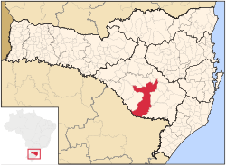
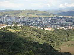
Lages is located in the mountain region of the state and is the largest municipality of it. It is the main city of this region, and borders the towns of Otacílio Costa, São Joaquim, and Correia Pinto. The main course of urban water is Carahá River.

Climate

Lages has a subtropical highland climate (Koppen: Cfb), with an annual mean temperature of 16 °C (61 °F). Winter temperatures can stay below freezing, with occurrence of frost and snow. During the summer, temperatures may reach 30 °C (86 °F) and droughts may occur.

Records

Data by INMET shows that the lowest temperature recorded in the city between 1961 and 2017 was −6 °C (21 °F) on 14 July 2000 [3] and the highest was 34.5 °C (94.1 °F) on 9 January 2006. [4] On 1 October 2001, the city accumulated a record of 177 millimetres (7.0 in) of precipitation in a period of 24 hours. Previous large accumulations include 122 millimetres (4.8 in) on 22 October 1979 and 117.2 millimetres (4.61 in) on 16 April 1971. [5]

With 671.4 millimetres (26.43 in), August 1983 was the month with the most accumulated precipitation. [6] The lowest relative humidity observed was of 20% on 13 November 1971. [7]

Climate data for Lages (normals 1981 to 2010; extremes 1971 to 2017)
MonthJanFebMarAprMayJunJulAugSepOctNovDecYear
Record high °C (°F)34.5
(94.1)
34.3
(93.7)
33.2
(91.8)
30.8
(87.4)
27.9
(82.2)
25.6
(78.1)
26.9
(80.4)
31
(88)
32.4
(90.3)
32.6
(90.7)
34.4
(93.9)
33.9
(93.0)
34.5
(94.1)
Mean daily maximum °C (°F)26.6
(79.9)
26.4
(79.5)
25.4
(77.7)
22.5
(72.5)
19
(66)
17.4
(63.3)
17.1
(62.8)
19.2
(66.6)
19.5
(67.1)
21.6
(70.9)
24
(75)
26.1
(79.0)
22.1
(71.7)
Daily mean °C (°F)20.6
(69.1)
20.4
(68.7)
19.4
(66.9)
16.6
(61.9)
13.1
(55.6)
11.6
(52.9)
11.1
(52.0)
12.6
(54.7)
13.9
(57.0)
16.2
(61.2)
18
(64)
19.9
(67.8)
16.1
(61.0)
Mean daily minimum °C (°F)16.3
(61.3)
16.3
(61.3)
15.5
(59.9)
12.8
(55.0)
9.2
(48.6)
7.8
(46.0)
7.1
(44.8)
8
(46)
9.9
(49.8)
12.4
(54.3)
13.6
(56.5)
15.3
(59.5)
12.0
(53.6)
Record low °C (°F)5.4
(41.7)
7
(45)
2.3
(36.1)
−0.7
(30.7)
−3.4
(25.9)
−5.8
(21.6)
−6
(21)
−4.8
(23.4)
−4
(25)
0.2
(32.4)
2.9
(37.2)
3.2
(37.8)
−6
(21)
Average precipitation mm (inches)163
(6.4)
158
(6.2)
120
(4.7)
111.8
(4.40)
126
(5.0)
111.4
(4.39)
181.5
(7.15)
117.5
(4.63)
157.3
(6.19)
191.4
(7.54)
136
(5.4)
133.7
(5.26)
1,707.6
(67.26)
Average precipitation days1212108789810111010115
Average relative humidity (%)7879.979.881.183.284.883.3798079.975.675.280.0
Mean monthly sunshine hours 198.5168.7180158.6149.1129143.3163.3137.1150.9200.9207.61,987
Source: Instituto Nacional de Meteorologia (INMET); data for the period of 1981-2010 [8] Absolute temperature records: 1 January 1961 to 3 April 2017) [3] [4]

Neighborhoods

Lages contains seventy-two neighborhoods: [9]

Related Research Articles

<span class="mw-page-title-main">Florianópolis</span> Capital city of Santa Catarina, Brazil

Florianópolis is the capital and second largest city of the state of Santa Catarina, in the South region of Brazil. The city encompasses Santa Catarina Island and surrounding small islands, as well as part of the mainland. It has a population of 508,826, according to the 2020 IBGE population estimate, the second-most populous city in the state, and the 47th in Brazil. The metropolitan area has an estimated population of 1,111,702, the 21st largest in the country. The city is known for having the country's third highest Human Development Index score among all Brazilian cities (0.847).

<span class="mw-page-title-main">Pelotas</span> Place in south Brazil

Pelotas is a Brazilian city and municipality (município), the fourth most populous in the southern state of Rio Grande do Sul, after Porto Alegre, Caxias do Sul and Canoas. It is located 270 km (168 mi) from Porto Alegre, the state's capital city, and 130 km (80.8 mi) from the Uruguayan border. The Lagoa dos Patos lies to the east and the São Gonçalo Channel lies to the south, separating Pelotas from the city of Rio Grande.

<span class="mw-page-title-main">Bragança Paulista</span> Municipality in Southeast, Brazil

Bragança Paulista is a municipality in the state of São Paulo in Brazil. The population is 170,533 in an area of 512.6 km². The elevation is 817 m.

<span class="mw-page-title-main">Campos do Jordão</span> Municipality in Southeast, Brazil

Campos do Jordão is a municipality in the state of São Paulo in southeastern Brazil. It is part of the Metropolitan Region of Vale do Paraíba e Litoral Norte. The population is 52,405 in an area of 290.52 square kilometres (112.17 sq mi). The city is situated 1,628 metres (5,341 ft) above sea level and is the highest city in Brazil.

<span class="mw-page-title-main">Itapevi</span> Municipality in Southeast, Brazil

Itapevi is a Brazilian municipality in the state of São Paulo located in the western part of the Greater São Paulo metropolitan area. The population is 240,961 in an area of 82.7 km2.

<span class="mw-page-title-main">Ilhéus</span> Municipality in Nordeste, Brazil

Ilhéus is a major city located in the southern coastal region of Bahia, Brazil, 211 km south of Salvador, the state's capital. The city was founded in 1534 as Vila de São Jorge dos Ilhéus and is known as one of the most important tourism centers of the northeast of Brazil.

<span class="mw-page-title-main">Andrelândia</span> Municipality in the state of Minas Gerais, Brazil

Andrelândia is a Brazilian municipality in the state of Minas Gerais that is located in the Mesoregion of South and Southwest of Minas and hosts the Microregion of Andrelândia. It is 300 km away from the state capital, Belo Horizonte and occupies an area of approximately 1 005 km2. In 2014 its population was estimated at 12 507 inhabitants, being the 296th most populous municipality in the state of Minas Gerais and the second of its microregion.

<span class="mw-page-title-main">Montijo, Portugal</span> Municipality in Lisbon, Portugal

Montijo is a city and municipality in Setúbal District in Portugal. Its name was Aldeia Galega do Ribatejo or simply Aldeia Galega until 1930. The population in 2021 was 55,732, in an area of 348.62 km2. The city of Montijo proper had a population of 25,719 in 2001.

<span class="mw-page-title-main">Bangu, Rio de Janeiro</span> Neighborhood in Rio de Janeiro, Rio de Janeiro, Brazil

Bangu is a neighborhood in the West Zone of Rio de Janeiro, Brazil. It is a middle-class neighborhood. It is located in the western area of the city being one of the most populated districts, with 244,518 inhabitants [1] distributed in an area of 4570.69 ha. Located in the geographic center of the city, the neighborhood is close to Campo Grande, Senador Camará, Vila Aliança, Padre Miguel and Realengo. On November 22, 2004, the mayor of Rio de Janeiro César Maia created by decree the district Gericinó. The neighborhood was originally part of the neighborhood of Bangu, the region where the penitentiary of Bangu is located, besides Bangu dump. The region is where Gericinó was located containing the sub-district of the Aqueduct. Since 2004, the complex of Bangu and dump of Bangu, no longer belong to the neighborhood of Bangu.

<span class="mw-page-title-main">Caicó</span> Municipality in Nordeste, Brazil

Caicó, also known as the City of Prince, is a municipality in the Seridó Ocidental microregion and Central Potiguar mesoregion, in Rio Grande do Norte state, Northeast Brazil. With a population of 68 726 inhabitants (2021), it is the seventh most populous city of Rio Grande do Norte and the second in the countryside of the state, after Mossoró.

<span class="mw-page-title-main">Rio Grande, Rio Grande do Sul</span> Municipality in South, Brazil

Rio Grande is a municipality (município) and one of the oldest cities in the Brazilian state of Rio Grande do Sul. It was the state capital from 1835 to 1845. It is the most important port city in the state and has one of the most important maritime ports in Brazil.

<span class="mw-page-title-main">Realengo</span> Neighborhood in Rio de Janeiro, Rio de Janeiro, Brazil

Realengo is a neighborhood in the West Zone of Rio de Janeiro, Brazil. The lower and middle-class neighborhood is between the Mendanha and Pedra Branca mountains. It is located between the mountains of Pedra Branca and Mendanha in the northern of the called West Zone of the city, owned and named the XXXIII Administrative Region which encompasses the entire east around the neighborhood. Realengo usually has the highest temperatures in the city, even though the winter nights are often cold because of the proximity to the mountains. Created on November 20, 1815, every year on this day the city's birthday is celebrated with the Week of Realengo. Pedro I of Brazil and Pedro II of Brazil used to go to the farm of Santa Cruz by the Estrada Real de Santa Cruz, passing by Realengo, where they often stayed.

<span class="mw-page-title-main">Climate of Brazil</span> Overview of the climate of Brazil

The climate in Brazil varies considerably from mostly tropical north to temperate zones south of the Tropic of Capricorn.

<span class="mw-page-title-main">União da Vitória</span> City in South, Brazil

União da Vitória is a municipality in the state of Paraná in Brazil. Its population was about 57,913 people in 2020. In the economic area, União da Vitória's GDP is US$115,364,648.65.

<span class="mw-page-title-main">Porto União</span> Place in South, Brazil

Porto União is a city located in the Northern Plateau in the State of Santa Catarina and on the left bank of Iguazu River, bordering the city of União da Vitória, Paraná. In 2020, its population was estimated in 35,543 inhabitants.

<span class="mw-page-title-main">São Joaquim</span> Municipality in South, Brazil

São Joaquim is a municipality in the state of Santa Catarina, situated in southern Brazil. Its population in 2020 was 27,139 inhabitants. Located in the Planalto Serrano, it lies 136 km from Tubarão, 81 km from Lages and 227 km from Florianópolis. The town is home to a variety of ethnic groups, including Italian, German, Portuguese, Japanese and Afro-Brazilians. There are also many people from other states in Brazil, especially from Rio Grande do Sul.

<span class="mw-page-title-main">Maria da Fé</span> Municipality in Southeast, Brazil

Maria da Fé is a Brazilian municipality located in the state of Minas Gerais. Its population as of 2020 is estimated to be 14,056 people. The area of the municipality is 203.774 km2. The city belongs to the mesoregion South/South-West of Minas Gerais and to the microregion of Itajubá.

<span class="mw-page-title-main">Patos</span> Municipality in Northeast, Brazil

Patos is a municipality of the state of Paraíba in the Northeast Region of Brazil. It is classified by the Brazilian Institute of Geography and Statistics as a sub-regional center A.

Alto da Boa Vista is a neighborhood in the North Zone of Rio de Janeiro, Brazil.

<span class="mw-page-title-main">Captaincy of Santa Catarina</span> Former Portuguese captaincy in Brazil

The Captaincy of Santa Catarina was an administrative division of colonial Brazil created on August 11, 1738, in the southernmost territories of the Captaincy of São Paulo. The government was officially installed on March 7, 1739, with the first governor being José da Silva Pais.

References

  1. "Population". Instituto Brasileiro de Geografia e Estatística. Retrieved 16 February 2024.
  2. "Ranking - Índice de Desenvolvimento Humano Municipal - 2010" (PDF). United Nations Development Programme (UNDP). Archived from the original (PDF) on July 8, 2014. Retrieved August 1, 2013.
  3. 1 2 "BDMEP - série histórica - dados diários - temperatura mínima (°C) - Lages". Instituto Nacional de Meteorologia. Retrieved 17 July 2015.
  4. 1 2 "BDMEP - série histórica - dados diários - temperatura máxima (°C) - Lages". Instituto Nacional de Meteorologia. Retrieved 17 July 2015.
  5. "BDMEP - série histórica - dados diários - precipitação (mm) - Lages". Instituto Nacional de Meteorologia. Retrieved 17 July 2015.
  6. "BDMEP - série histórica - dados mensais - precipitação total (mm) - Lages". Instituto Nacional de Meteorologia. Retrieved 2 May 2014.
  7. "BDMEP - série histórica - dados horários - umidade relativa (%) - Lages". Instituto Nacional de Meteorologia. Retrieved 17 July 2015.
  8. "Normais Climatológicas do Brasil". Instituto Nacional de Meteorologia. Retrieved 13 May 2018.
  9. "Bairros da cidade Lages". Guia Mais. Archived from the original on 20 February 2017.
  10. "Araucária, Lages". City Facts. Archived from the original on 29 October 2021.
  11. "Boqueirão, Lages". City Facts. Archived from the original on 29 October 2021.
  12. "Dom Daniel, Lages". City Facts. Archived from the original on 29 October 2021.
  13. "Frei Rogério, Lages". City Facts. Archived from the original on 7 November 2021.
  14. "Ponte Grande, Lages". City Facts. Archived from the original on 29 October 2021.
  15. "Pte. Grande". Google maps.
  16. "Santa Mônica, Lages". City Facts. Archived from the original on 3 November 2021.
  17. "Vista Alegre, Lages". City Facts. Archived from the original on 3 November 2021.