Palmitos

Last updated
Palmitos
Municipality
Bandeira de Palmitos (Santa Catarina).jpg
0.571352001231854334 palmitos.png
CountryFlag of Brazil.svg  Brazil
Region South
State Santa Catarina
MesoregionOeste Catarinense
Population
 (2020 [1] )
  Total16,157
Time zone UTC -3

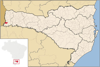
Palmitos is a municipality in the state of Santa Catarina in the South region of Brazil. [2] [3] [4] [5]

Contents

Schools

N.E.M Ida Hilda Casella Vidori

The Ida Hilda Casella Vidori Educational Center is located in the urban area, in the highway from Palmitos to St Lucia, in the neighborhood Nossa Senhora do Rosário, in the city of Palmitos, state of Santa Catarina. It was created by ordinance No. 007/99 by the Mayor Elmo Fiegenbaum. The Educational Center is maintained and administered by the Municipal Education Secretary of the City of Palmitos, SC, offering education from pre-school to elementary school. The Center serves children from 4 to 15 years old, coming from rural communities as: Pinhalzinho, Santa Catarina, Barra Grande, Caititu, Baixa Diamantina, Progresso, Caravagio e Floresta among others, and especially three districts: Progress, Nossa Senhora do Rosario and Aurora.

See also

Related Research Articles

Caibi Municipality in South, Brazil

Caibi is a municipality in the state of Santa Catarina in the South region of Brazil. It covers 174.84 km2 (67.51 sq mi), and has a population of 6,130 with a population density of 35.57 inhabitants per square kilometer.

Cunha Porã Municipality in South, Brazil

Cunha Porã is a municipality in the state of Santa Catarina in the South region of Brazil. It was created in 1958 out of the existing municipality of Palmitos.

Maravilha, Santa Catarina Municipality in South, Brazil

Maravilha, Santa Catarina is a municipality in the state of Santa Catarina in the South region of Brazil. It was created in 1958 out of the existing municipality of Palmitos.

Saltinho, Santa Catarina is a municipality in the state of Santa Catarina in the South region of Brazil.

Santa Terezinha do Progresso is a municipality in the state of Santa Catarina in the South region of Brazil.

São Carlos is a municipality in the state of Santa Catarina in the South region of Brazil.
Tunápolis Municipality in South, Brazil

Tunápolis is a municipality in the state of Santa Catarina in the South region of Brazil.

São José do Cedro Municipality in South, Brazil

São José do Cedro is a municipality in the state of Santa Catarina in the South region of Brazil.

Anchieta, Santa Catarina is a municipality in the state of Santa Catarina in the South region of Brazil.

São Miguel da Boa Vista Municipality in South, Brazil

São Miguel da Boa Vista is a municipality in the state of Santa Catarina in the South region of Brazil.

Saudades, Santa Catarina Municipality in South, Brazil

Saudades, Santa Catarina is a municipality in the state of Santa Catarina in the South region of Brazil. It was created in 1961, its area being taken from the existing municipality of São Carlos; in 1964 its eastern district was removed to form the new municipality of Nova Erechim.

Serra Alta is a municipality in the state of Santa Catarina in the South region of Brazil.

Sul Brasil Municipality in South, Brazil

Sul Brasil is a municipality in the state of Santa Catarina in the South region of Brazil. It was created in 1961 by division of the municipality of Modelo.

Palma Sola, Santa Catarina is a municipality in the state of Santa Catarina in the South region of Brazil.

Princesa, Santa Catarina is a municipality in the state of Santa Catarina in the South region of Brazil.

Riqueza is a municipality in the state of Santa Catarina in the South region of Brazil.

Mondaí is a municipality in the state of Santa Catarina in the South region of Brazil.

Iporã do Oeste is a municipality in the state of Santa Catarina in the South region of Brazil.

Tigrinhos is a municipality in the state of Santa Catarina in the South region of Brazil.

Cerro Negro, Santa Catarina is a municipality in the state of Santa Catarina in the South region of Brazil.

References

  1. IBGE 2020
  2. "Divisão Territorial do Brasil" (in Portuguese). Divisão Territorial do Brasil e Limites Territoriais, Instituto Brasileiro de Geografia e Estatística (IBGE). July 1, 2008. Retrieved December 17, 2009.
  3. "Estimativas da população para 1º de julho de 2009" (PDF) (in Portuguese). Estimativas de População, Instituto Brasileiro de Geografia e Estatística (IBGE). August 14, 2009. Retrieved December 17, 2009.
  4. "Ranking decrescente do IDH-M dos municípios do Brasil" (in Portuguese). Atlas do Desenvolvimento Humano, Programa das Nações Unidas para o Desenvolvimento (PNUD). 2000. Archived from the original on October 3, 2011. Retrieved December 17, 2009.
  5. "Produto Interno Bruto dos Municípios 2002-2005" (PDF) (in Portuguese). Instituto Brasileiro de Geografia e Estatística (IBGE). December 19, 2007. Retrieved December 17, 2009.

Coordinates: 27°04′03″S53°09′40″W / 27.0675°S 53.1611°W / -27.0675; -53.1611