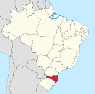
Santa Catarina is a state in the South Region of Brazil. It is the 7th smallest state in total area and the 11th most populous. Additionally, it is the 9th largest settlement, with 295 municipalities. Catholicism is the religion of the majority of the population. The official language, as in other Brazilian federative units, is the Portuguese language. The state covers an area of 95,733 km2, reaching a larger area than Portugal or the sum of the Brazilian states of Rio de Janeiro, Espirito Santo, and the Federal District.

Santa Catarina is a concelho (municipality) of Cape Verde. It is situated in the western part of the island of Santiago. Its seat is the city of Assomada. Its population was 45,920 in 2017 (estimate). Its area is 242.6 km2 (93.7 sq mi).
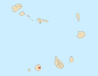
Santa Catarina do Fogo is a concelho (municipality) of Cape Verde. Situated in the southeastern part of the island of Fogo, it covers 32% of the island area, and is home to 14% of its population. Its seat is the city Cova Figueira. The Municipality of Santa Catarina do Fogo was created in 2005; before 2005, it was a parish of the Municipality of São Filipe.

Santa Catarina Island is an island in the Brazilian state of Santa Catarina, located off the southern coast. It is home to the state capital, Florianópolis.
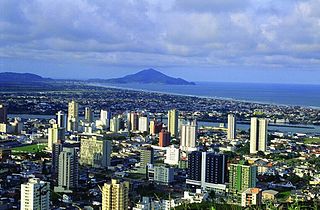
Itajaí is a municipality in the state of Santa Catarina, Brazil. It is located on the northern central coast of Santa Catarina and is part of the Vale do Itajaí Mesoregion, on the right bank of the Itajaí-Açu river mouth. The city has the 2nd largest gross domestic product and the highest per capita income in the State of Santa Catarina.

Also see Port of Tubarao

Campos Novos is a city in Santa Catarina, in the Southern Region of Brazil. Campos Novos is a pioneer in production of pollen and the biggest grain and oat producer of Santa Catarina. The municipality invests also into fatstock and poultry farming.

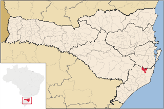
São Joaquim is a municipality in the state of Santa Catarina, situated in southern Brazil. It is located at latitude 28° 17' 38" south and longitude 49° 55' 54" west, with an altitude of 1,360 meters (4,460 ft). Its population in 2004 was 23,114 inhabitants. Located in the Planalto Serrano, it lies 136 km from Tubarão, 81 km from Lages and 227 km from Florianópolis. The town is home to a variety of ethnic groups, including Italian, Portuguese, Japanese and Afro- Brazilians, though composed mainly of descendants of German and Swedish immigrants. There is also a large proportation of the population from other states in Brazil, especially from Rio Grande do Sul.

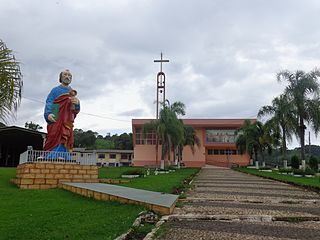
São Pedro de Alcântara, Santa Catarina is a municipality in the state of Santa Catarina in the South region of Brazil.
Schroeder (Schröder) is a municipality in the state of Santa Catarina in the South region of Brazil.
Nova Erechim is a municipality in the state of Santa Catarina in the South region of Brazil. It was created in 1964, its area being taken from the existing municipality of Saudades.
Palmitos is a municipality in the state of Santa Catarina in the South region of Brazil.
Pinhalzinho, Santa Catarina is a municipality in the state of Santa Catarina in the South region of Brazil. It was created in 1961, its area being taken from the existing municipality of São Carlos.
Saudades, Santa Catarina is a municipality in the state of Santa Catarina in the South region of Brazil. It was created in 1961, its area being taken from the existing municipality of São Carlos; in 1964 its eastern district was removed to form the new municipality of Nova Erechim.
Sul Brasil is a municipality in the state of Santa Catarina in the South region of Brazil. It was created in 1961 by division of the municipality of Modelo.
São José do Cerrito is a municipality in the state of Santa Catarina in the South region of Brazil. It was created in 1961 out of the existing municipality of Lages.
São Martinho, Santa Catarina is a municipality in the state of Santa Catarina in the South region of Brazil.
Vidal Ramos is a municipality in the state of Santa Catarina in the South region of Brazil.

Salete is a municipality in the state of Santa Catarina in the South region of Brazil.


