Paraná is one of the 26 states of Brazil, in the south of the country. It is bordered in the north by São Paulo state, in the east by the Atlantic Ocean, in the south by Santa Catarina state and the province of Misiones, Argentina, and in the west by Mato Grosso do Sul and Paraguay, with the Paraná River as its western boundary. It is subdivided into 399 municipalities, and its capital is the city of Curitiba. Other major cities are Londrina, Maringá, Ponta Grossa, Cascavel, São José dos Pinhais and Foz do Iguaçu. The state is home to 5.4% of the Brazilian population and generates 6.2% of the Brazilian GDP.

Rio Grande do Sul is a state in the southern region of Brazil. It is the fifth-most populous state and the ninth-largest by area. Located in the southernmost part of the country, Rio Grande do Sul is bordered clockwise by Santa Catarina to the north and northeast, the Atlantic Ocean to the east, the Uruguayan departments of Rocha, Treinta y Tres, Cerro Largo, Rivera, and Artigas to the south and southwest, and the Argentine provinces of Corrientes and Misiones to the west and northwest. The capital and largest city is Porto Alegre. The state has the highest life expectancy in Brazil, and the crime rate is relatively low compared to the Brazilian national average. Despite the high standard of living, unemployment is still high in the state, as of 2017. The state has 5.4% of the Brazilian population and it is responsible for 6.6% of the Brazilian GDP.
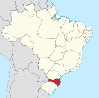
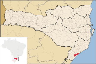
Santa Catarina is one of the 27 federative units of Brazil. It is located in the centre of the country's Southern region. It is bordered to the north by the state of Paraná, to the south by the state of Rio Grande do Sul, to the east by the Atlantic Ocean, and to the west by the Argentine province of Misiones.

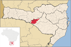
Chapecó is a municipality in the state of Santa Catarina, in the Southern Region of Brazil. Being a major industrial, financial and educational center, it is a major producer of industrialized food products. Considered a medium city, with a population estimated at 224,013 inhabitants, it is among the four most important cities in the state. It belongs to the Meso-region of Western Santa Catarina and to the Microregion of Chapecó.
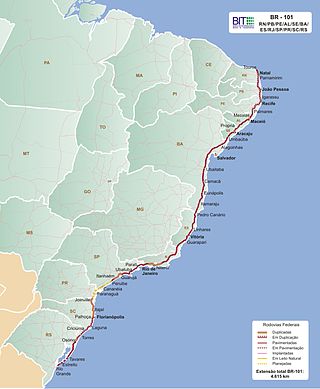
The BR-101 is a longitudinal highway of Brazil. It is the longest in the country with a length of nearly 4,800 km (3,000 mi), and it is considered one of the most important highways in the country, along with BR-116.

The Brazilian Highway System is a network of trunk roads administered by the Ministry of Transport of Brazil. It is constructed, managed and maintained by the National Department of Transport Infrastructure (DNIT), federal agency linked to the Ministry of Infrastructure, and the public works departments of state governments.

The Contestado War, broadly speaking, was a guerrilla war for land between settlers and landowners, the latter supported by the Brazilian state's police and military forces, that lasted from October 1912 to August 1916.
Araranguá is a city located in the southern part of Santa Catarina state, in the south of Brazil. It has 68,867 inhabitants and was settled mainly by Portuguese and Italians. Araranguá is known as "A Cidade das Avenidas" because of its wide roads.

Polish Brazilians refers to Brazilians of full or partial Polish ancestry who are aware of such ancestry and remain connected, to some degree, to Polish culture, or Polish-born people permanently residing in Brazil. Also, a Polish Brazilian may have one Polish parent.

The Roman Catholic Archdiocese of Florianópolis is an archdiocese located in the city of Florianópolis in Brazil.

Russian Brazilians are Brazilian citizens of full or partial Russian ethnic background or Russian-born people residing in Brazil. The term can also refer to someone with a Brazilian mother and Russian father, or vice versa.

The coastline of Brazil measures 7,491 km, making it the 16th longest national coastline in the world. The coastline touches exclusively the Atlantic Ocean. Brazil's coastline has many geographical features such as islands, reefs, bays, and its 2,095 beaches.

Caçador is a municipality in the state of Santa Catarina in the South region of Brazil.

The Tietê Bus Terminal is the largest bus terminal in Latin America, and the second largest in the world, after the Port Authority Bus Terminal in New York City. The terminal is located in the Santana district in the city of São Paulo, Brazil. The official name in Portuguese is Terminal Rodoviário Governador Carvalho Pinto, named after Carlos Alberto Alves de Carvalho Pinto, a former Governor of the State of São Paulo.
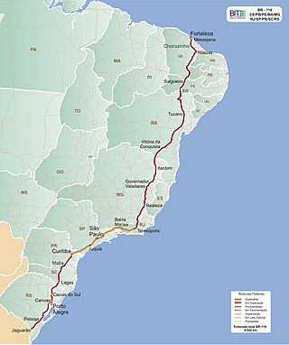
BR-116 is a federal route of highways of Brazil and the longest highway in the country, with 4,542 km (2,822 mi) of extension. The road connects Fortaleza, Ceará, one of the largest Northeast Brazil metropolises, to the southern city of Jaguarão, Rio Grande do Sul, in the border with Uruguay. It is also the longest highway in the country to be completely paved. It is considered one of the most important highways in the country, along with BR-101.
The Brazilian municipal elections of 2012 took place on October 7 and on October 28. Over 138 million voters chose mayors, deputy mayors and city councillors for the 5,568 municipalities of Brazil. These were the first elections in which the recently registered parties Partido Pátria Livre (PPL) and Partido Social Democrático (PSD) participated; they were both recognized by the Superior Electoral Court in 2011. Political parties whose candidates wished to run for the 2012 elections had to be registered at the TSE for at least one year before the election date, while candidates also had to be affiliated to a party for the same period of time. Conventions for the selection of candidates within the parties occurred between 10 and 30 June, while the registry of candidates and alliances with the Regional Electoral Courts took place until July 5. Electoral campaign was authorized from the moment a candidacy had been registered. The free electoral program – two daily slots on free-to-air TV and radio for political advertising paid by the Electoral Justice fund – ran weekdays from 21 August until 4 October. According to the current Brazilian electoral law, the two-round system – should the leading candidate receive less than 50% +1 of the votes – is only available for cities with more than 200,000 voters. This includes all state capitals, with the exception of Boa Vista, Roraima and Palmas, Tocantins, plus 59 other municipalities. The free electoral program for the second round ran from 13 October until 26 October.
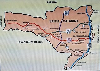
BR-470 is an east-west Brazilian federal highway that starts in Navegantes, Santa Catarina, and crosses the Gaucho range and highlands. It stretches approximately 833 km, passing through cities such as Itajaí, Blumenau, Rio do Sul, Curitibanos, Campos Novos, Bento Gonçalves, Veranópolis and Montenegro and ends in Camaquã, Rio Grande do Sul.

NSC TV Centro-Oeste is a television station in Joaçaba, Santa Catarina, Brazil, affiliated with TV Globo, member of NSC TV and owned by NSC Comunicação. NSC TV Centro-Oeste's studios are located in the Cruzeiro do Sul district and its transmitter is located in the Boa Vista district.