
Brussels, officially the Brussels-Capital Region, is a region of Belgium comprising 19 municipalities, including the City of Brussels, which is the capital of Belgium. The Brussels-Capital Region is located in the central portion of the country and is a part of both the French Community of Belgium and the Flemish Community, but is separate from the Flemish Region and the Walloon Region.

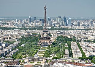
Paris is the capital and most populous city of France. With an official estimated population of 2,102,650 residents as of 1 January 2023 in an area of more than 105 km2 (41 sq mi), Paris is the fifth-most populated city in the European Union and the 30th most densely populated city in the world in 2022. Since the 17th century, Paris has been one of the world's major centres of finance, diplomacy, commerce, culture, fashion, gastronomy and many areas. For its leading role in the arts and sciences, as well as its early and extensive system of street lighting, in the 19th century, it became known as the City of Light.

Canaan was a Semitic-speaking civilization and region of the Southern Levant in the Ancient Near East during the late 2nd millennium BC. Canaan had significant geopolitical importance in the Late Bronze Age Amarna Period as the area where the spheres of interest of the Egyptian, Hittite, Mitanni, and Assyrian Empires converged or overlapped. Much of present-day knowledge about Canaan stems from archaeological excavation in this area at sites such as Tel Hazor, Tel Megiddo, En Esur, and Gezer.

The Chūbu region, Central region, or Central Japan is a region in the middle of Honshū, Japan's main island. In a wide, classical definition, it encompasses nine prefectures (ken): Aichi, Fukui, Gifu, Ishikawa, Nagano, Niigata, Shizuoka, Toyama, and Yamanashi.

Metropolitan Manila, formally the National Capital Region and commonly called Metro Manila, is the capital region and largest metropolitan area of the Philippines. The region is located on the eastern shore of Manila Bay, between the Central Luzon and Calabarzon regions. It consists of 16 highly urbanized cities: the City of Manila, Caloocan, Las Piñas, Makati, Malabon, Mandaluyong, Marikina, Muntinlupa, Navotas, Parañaque, Pasay, Pasig, Quezon City, San Juan, Taguig, and Valenzuela, and one municipality: Pateros. The region encompasses an area of 619.57 square kilometers (239.22 sq mi) and a population of 13,484,462 as of 2020. It is the second most populous and the most densely populated region in the Philippines. It is also the 9th most populous metropolitan area in Asia and the 6th most populous urban area in the world.

The Kansai region or the Kinki region lies in the southern-central region of Japan's main island Honshū. The region includes the prefectures of Nara, Wakayama, Kyoto, Osaka, Hyōgo and Shiga, often also Mie, sometimes Fukui, Tokushima and Tottori. The metropolitan region of Osaka, Kobe and Kyoto is the second-most populated in Japan after the Greater Tokyo Area.

The Mid-Atlantic is a region of the United States located in the overlap between the Northeastern and Southeastern states of the United States. The region typically includes the five states of New York, New Jersey, Pennsylvania, Delaware, and Maryland, as well as the District of Columbia, and occasionally Virginia and West Virginia. The region has its origin in the 18th century Middle Colonies of the British Empire.

The Chūgoku region, also known as the San'in-San'yō region, is the westernmost region of Honshū, the largest island of Japan. It consists of the prefectures of Hiroshima, Okayama, Shimane, Tottori and Yamaguchi. In 2010, it had a population of 7,563,428.

In the Philippines, regions are administrative divisions that primarily serve to coordinate planning and organize national government services across multiple local government units (LGUs). Most national government offices provide services through their regional branches instead of having direct provincial or city offices. Regional offices are usually but not necessarily located in the city designated as the regional center.

Calabarzon, sometimes referred to as Southern Tagalog and designated as Region IV‑A, is an administrative region in the Philippines. The region comprises five provinces: Batangas, Cavite, Laguna, Quezon, and Rizal; and one highly urbanized city, Lucena. It is the most populous region in the Philippines according to the Philippine Statistics Authority (PSA), having over 16.1 million inhabitants in 2020, and is also the country's second most densely populated after the National Capital Region. It is situated southeast of Metro Manila, and is bordered by Manila Bay and South China Sea to the west, Lamon Bay and the Bicol Region to the east, Tayabas Bay and the Sibuyan Sea to the south, and Central Luzon to the north. It is home to places like Mount Makiling near Los Baños, Laguna, and Taal Volcano in Batangas.

Cagayan Valley, designated as Region II, is an administrative region in the Philippines. Located in the northeastern section of Luzon, it is composed of five Philippine provinces: Batanes, Cagayan, Isabela, Nueva Vizcaya, and Quirino. The region hosts four chartered cities: Cauayan, Ilagan, Santiago, and Tuguegarao.

Northern Mindanao is an administrative region in the Philippines, designated as Region X. It comprises five provinces: Bukidnon, Camiguin, Misamis Occidental, Misamis Oriental, and Lanao del Norte, and two cities classified as highly urbanized, all occupying the north-central part of Mindanao island, and the island-province of Camiguin. The regional center is Cagayan de Oro. Lanao del Norte was transferred to Northern Mindanao from Region XII by virtue of Executive Order No. 36 in September 2001.

Davao Region, formerly called Southern Mindanao, is an administrative region in the Philippines, designated as Region XI. It is situated at the southeastern portion of Mindanao and comprises five provinces: Davao de Oro, Davao del Norte, Davao del Sur, Davao Oriental and Davao Occidental.

Western Visayas is an administrative region in the Philippines, numerically designated as Region VI. It consists of six provinces and two highly urbanized cities. The regional center is Iloilo City. The region is dominated by the native speakers of four Visayan languages: Hiligaynon, Kinaray-a, Aklanon and Capiznon. The land area of the region is 20,794.18 km2 (8,028.68 sq mi), and with a population of 7,954,723 inhabitants, it is the second most populous region in the Visayas after Central Visayas.

Central Luzon, designated as Region III, is an administrative region in the Philippines, primarily serving to organize the 7 provinces of the vast central plains of the island of Luzon, for administrative convenience. The region contains the largest plain in the country and produces most of the country's rice supply, earning itself the nickname "Rice Granary of the Philippines". Its provinces are: Aurora, Bataan, Bulacan, Nueva Ecija, Pampanga, Tarlac and Zambales. Pangasinan was formerly a province of Central Luzon before President Marcos signed Presidential Decree No. 1, 1972, incorporating it into Ilocos Region. Additionally, the province of Aurora was part of the defunct political region Southern Tagalog when the region was divided into Calabarzon and Mimaropa, upon the issuance of Executive Order No. 103, dated May 17, 2002, by then-President Gloria Macapagal Arroyo, which transferred Aurora to Central Luzon.
The Île-de-France is the most populous of the eighteen regions of France, with an official estimated population of 12,271,794 residents on 1 January 2023. Centred on the capital Paris, it is located in the north-central part of the country and often called the Paris Region. Île-de-France is densely populated and retains a prime economic position on the national stage: though it covers only 12,012 square kilometres, about 2% of metropolitan French territory, its 2017 population was nearly one-fifth of the national total.

Grand Est is an administrative region in northeastern France. It superseded three former administrative regions, Alsace, Champagne-Ardenne and Lorraine, on 1 January 2016 under the provisional name of Alsace-Champagne-Ardenne-Lorraine, as a result of territorial reform which had been passed by the French Parliament in 2014.

Greater London is the administrative area of London, England, coterminous with the London region. It contains 33 local government districts: the 32 London boroughs, which forms the ceremonial county of Greater London; and the City of London, which forms a distinct ceremonial county. The Greater London Authority, its devolved governance body, is responsible for strategic local government across the region, whilst regular local government is the responsibility of the borough councils and the City of London Corporation.


