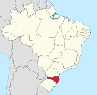
Santa Catarina is a state in the South Region of Brazil. It is the 7th smallest state in total area and the 11th most populous. Additionally, it is the 9th largest settlement, with 295 municipalities. The state, which has 3.4% of the Brazilian population, is responsible for 3.8% of the Brazilian GDP.
São João, Portuguese for "Saint John", may refer to:
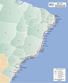
The BR-101 is a longitudinal highway of Brazil. It is the longest in the country with a length of nearly 4,800 km (3,000 mi), and it is considered one of the most important highways in the country, along with BR-116.

Lages is a Brazilian municipality located in the central part of the state of Santa Catarina, in the region known in Portuguese as "Planalto Serrano".

Ponte Alta is a city in Santa Catarina, in the Southern Region of Brazil.

Modelo is a city in Santa Catarina, in the Southern Region of Brazil. The area was granted municipality status in 1961, its area being taken from the existing municipality of São Carlos; Three areas have subsequently been removed to form the new municipalities of Bom Jesus do Oeste, Serra Alta and Sul Brasil.

Braço do Norte is a municipality in the state of Santa Catarina in the South region of Brazil. Most known for its agriculture and square fabrics, it was colonized by mostly German immigrants in the Second World War, such as Polish and Italians.
Rio do Sul is a municipality in the state of Santa Catarina in the South region of Brazil.

Palmeiras-Barra Funda Intermodal Terminal is the second largest intermodal transportation hub in São Paulo, Brazil. The terminal has access to the São Paulo Metro, CPTM commuter rail, and numerous bus lines.

Events from the year 2012 in Brazil.

Events in the year 1892 in Brazil.
Events in the year 2005 in Brazil.
Events in the year 2006 in Brazil.

Events in the year 1960 in Brazil.
Infraestruturas de Portugal, S.A. (IP) is a state-owned company which resulted from the merger of Rede Ferroviária Nacional (REFER) and Estradas de Portugal (EP). It manages the Portuguese rail and road infrastructure.