Vidal Ramos | |
|---|---|
Municipality | |
 Seal | |
| Country | |
| Region | South |
| State | Santa Catarina |
| Mesoregion | Vale do Itajai |
| Time zone | UTC -3 |
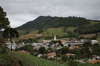
Vidal Ramos is a municipality in the state of Santa Catarina in the South region of Brazil. [1] [2] [3] [4]
Vidal Ramos | |
|---|---|
Municipality | |
| Seal | |
| Country | |
| Region | South |
| State | Santa Catarina |
| Mesoregion | Vale do Itajai |
| Time zone | UTC -3 |
Vidal Ramos is a municipality in the state of Santa Catarina in the South region of Brazil. [1] [2] [3] [4]
Vidal Ramos received city status by state law No. 272 in December 1956, with territory taken from the neighbouring municipality of Brusque. [1]
It was named after the Governor of Santa Catarina of the same name. [5]
It is located at a latitude 27º23'31 "South and longitude 49º21'21" West, with an altitude of 370 meters. Its estimated population in 2011 was 6287 inhabitants.
It has an area of 343.81 square kilometers.
Rancho Queimado is a municipality in the state of Santa Catarina in the South region of Brazil.
Leoberto Leal is a municipality in the state of Santa Catarina in the South region of Brazil.
Rio Negrinho is a municipality in the state of Santa Catarina in the South region of Brazil.
Tangará is a municipality in the state of Santa Catarina in the South region of Brazil.

Celso Ramos is a municipality in the state of Santa Catarina in the South region of Brazil.
Rio Rufino is a municipality in the state of Santa Catarina in the South region of Brazil.
São Ludgero is a municipality in the state of Santa Catarina in the South region of Brazil.

Rio Fortuna is a municipality in the state of Santa Catarina in the South region of Brazil.
Sangão is a municipality in the state of Santa Catarina in the South region of Brazil.
Santa Rosa de Lima, Santa Catarina is a municipality in the state of Santa Catarina in the South region of Brazil.
Treviso, Santa Catarina is a municipality in the state of Santa Catarina in the South region of Brazil.
Jacinto Machado is a municipality in the state of Santa Catarina in the South region of Brazil.
Maracajá is a municipality in the state of Santa Catarina in the South region of Brazil.
Morro Grande is a municipality in the state of Santa Catarina in the South region of Brazil.
Santa Rosa do Sul is a municipality in the state of Santa Catarina in the South region of Brazil.
Passo de Torres is a municipality in the state of Santa Catarina in the South region of Brazil.
São João do Sul is a municipality in the state of Santa Catarina in the South region of Brazil.
Timbé do Sul is a municipality in the state of Santa Catarina in the South region of Brazil.
Rio dos Cedros is a municipality in the state of Santa Catarina in the South region of Brazil.

Rodeio is a municipality in the state of Santa Catarina in the South region of Brazil.
Capital: Florianópolis | |||||||||
| Grande Florianópolis |
|  | |||||||
| Norte Catarinense |
| ||||||||
| Oeste Catarinense | |||||||||
| Serrana |
| ||||||||
| Sul Catarinense |
| ||||||||
| Vale do Itajai |
| ||||||||
Coordinates: 27°23′S49°22′W / 27.383°S 49.367°W
| This Santa Catarina, Brazil location article is a stub. You can help Wikipedia by expanding it. |