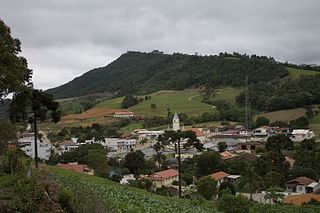
Rancho Queimado is a municipality in the state of Santa Catarina in the South region of Brazil.

Leoberto Leal is a municipality in the state of Santa Catarina in the South region of Brazil.
São João Batista, Santa Catarina is a municipality in the state of Santa Catarina in the South region of Brazil.

Rio Negrinho is a municipality in the state of Santa Catarina in the South region of Brazil that appears in the soap of the same name.

Guaramirim is a municipality in the state of Santa Catarina in the South region of Brazil.

Ouro Verde, Santa Catarina is a municipality in the state of Santa Catarina in the South region of Brazil.
União do Oeste is a municipality in the state of Santa Catarina in the South region of Brazil. It was created in 1988 by division of the municipality of Coronel Freitas.

Água Doce is a municipality in the state of Santa Catarina in the South region of Brazil. The Morro do Capão Doce is situated in its territory.
Macieira is a municipality in the state of Santa Catarina in the South region of Brazil.
Correia Pinto is a municipality in the state of Santa Catarina in the South region of Brazil. It was created in 1982 out of the existing municipality of Lages.
Rio Rufino is a municipality in the state of Santa Catarina in the South region of Brazil.
Balneário Gaivota is a municipality in the state of Santa Catarina in the South region of Brazil. Balneario Gaivota has the largest beach shore in Santa Catarina.

São Ludgero is a municipality in the state of Santa Catarina in the South region of Brazil.
Santa Rosa de Lima, Santa Catarina is a municipality in the state of Santa Catarina in the South region of Brazil.

Urussanga is a municipality in the state of Santa Catarina in the South region of Brazil. The name means "very cold water" in the Tupi language.
Jacinto Machado is a municipality in the state of Santa Catarina in the South region of Brazil.
Meleiro is a municipality in the state of Santa Catarina in the South region of Brazil.
Morro Grande is a municipality in the state of Santa Catarina in the South region of Brazil.

José Boiteux is a municipality in the state of Santa Catarina in the South region of Brazil.

Rio do Campo is a municipality in the state of Santa Catarina in the South region of Brazil.


