Alfredo Wagner

Last updated
Alfredo Wagner
Alfredense
The Municipality of Alfredo Wagner
Municipality
Bandeira de Alfredo Wagner.png
Brasao alfredo wagner.png
Nickname: 
Sources of Capital
SantaCatarina Municip AlfredoWagner.svg
Coordinates: 27°42′00″S49°20′02″W / 27.70000°S 49.33389°W / -27.70000; -49.33389 Coordinates: 27°42′00″S49°20′02″W / 27.70000°S 49.33389°W / -27.70000; -49.33389
CountryFlag of Brazil.svg  Brazil
Region South
State Santa Catarina
Mesoregion Great Florianópolis
Microregion Tabuleiro
FoundedDecember 21, 1961
Mesoregion date IBGE/2008 [1]
Micoregion date IBGE/2008 [1]
Government
   Mayor Naudir Antonio Schmitz [2] (PMDB)
Population
 (2020 [3] )
  Total10,086
Time zone UTC−3 (BRT)
Postal Code
88450-000
Area code (48)
Nearby towns Angelina, Anitápolis, Bom Retiro, Chapadão do Lageado, Imbuia, Ituporanga, Leoberto Leal e Rancho Queimado
Distance to the capital78.1 km (48.5 mi)
Website www.alfredowagner.sc.gov.br

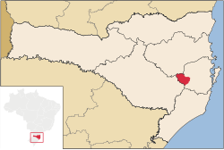
Alfredo Wagner is a municipality in the state of Santa Catarina in the South region of Brazil. [1] [4] [5] [6]

Contents

The municipality contains the Rio das Furnas Private Natural Heritage Reserve, created in 2002. [7]

The first attempts of colonizing Alfredo Wagner were made at nineteen military in the Morro do Trombudo. The expedition was unsuccessful because snow was abundant and the rain in the three years ravaged the region. Augusto Lima, in 1893, settled in Rivers Adaga and Caeté, accompanied by some settlers. The local passed the name "Barracão", the first name of "Alfredo Wagner". The name is a homage to the men of more worked for emancipation political-administrative the municipality, dismembering of Bom Retiro.[ clarification needed ]

Prehistory

In the start of the 1990s, teachers of University Federal of Santa Catarina found the fossil of a dinosaur, who lived 220 million years ago.

Colonization

The colonization the Alfredo Wagner mainly is the German and Italian, with the presence of Tyrolean of Italian language.

See also

Related Research Articles

<span class="mw-page-title-main">Marema</span> Municipality in South

Marema is a Brazilian municipality in the state of Santa Catarina.

<span class="mw-page-title-main">Maravilha, Santa Catarina</span> Municipality in South, Brazil

Maravilha, Santa Catarina is a municipality in the state of Santa Catarina in the South region of Brazil. It was created in 1958 out of the existing municipality of Palmitos.

São Bernardino is a municipality in the state of Santa Catarina in the South region of Brazil. It was created in 1995 out of the municipality of Campo Erê.

<span class="mw-page-title-main">Coronel Martins</span> Municipality in South, Brazil

Coronel Martins is a municipality in the state of Santa Catarina in the South region of Brazil. It was created in 1992 out of the existing municipality of São Domingos.

<span class="mw-page-title-main">Entre Rios, Santa Catarina</span> Municipality in South, Brazil

Entre Rios is a municipality in the state of Santa Catarina in the South region of Brazil. It was created in 1995 out the existing municipality of Marema.

Bandeirante is a municipality in the state of Santa Catarina in the South region of Brazil.

<span class="mw-page-title-main">Sul Brasil</span> Municipality in South, Brazil

Sul Brasil is a municipality in the state of Santa Catarina in the South region of Brazil. It was created in 1961 by division of the municipality of Modelo.

Tigrinhos is a municipality in the state of Santa Catarina in the South region of Brazil.

União do Oeste is a municipality in the state of Santa Catarina in the South region of Brazil. It was created in 1988 by division of the municipality of Coronel Freitas.

Arabutã is a municipality in the state of Santa Catarina in the South region of Brazil.

Salto Veloso is a municipality in the state of Santa Catarina in the South region of Brazil.

Ermo, Santa Catarina is a municipality in the state of Santa Catarina in the South region of Brazil.

<span class="mw-page-title-main">São Ludgero</span> Municipality in South, Brazil

São Ludgero is a municipality in the state of Santa Catarina in the South region of Brazil.

Sangão is a municipality in the state of Santa Catarina in the South region of Brazil.

Santa Rosa de Lima, Santa Catarina is a municipality in the state of Santa Catarina in the South region of Brazil.

<span class="mw-page-title-main">Braço do Norte</span> Municipality in South, Brazil

Braço do Norte is a municipality in the state of Santa Catarina in the South region of Brazil. Most known for its agriculture and square fabrics, it was colonized by mostly German immigrants in the Second World War, such as Polish and Italians.

<span class="mw-page-title-main">Gaspar, Santa Catarina</span> Municipality in South, Brazil

Gaspar, Santa Catarina is a municipality in the state of Santa Catarina in the South region of Brazil.

<span class="mw-page-title-main">Taió</span> Municipality in South, Brazil

Taió is a municipality in the state of Santa Catarina in the South region of Brazil.

<span class="mw-page-title-main">Trombudo Central</span> Municipality in South, Brazil

Trombudo Central is a municipality in the state of Santa Catarina in the South region of Brazil.

<span class="mw-page-title-main">Rio do Campo</span> Municipality in South, Brazil

Rio do Campo is a municipality in the state of Santa Catarina in the South region of Brazil.

References

  1. 1 2 3 "Divisão Territorial do Brasil". Divisão Territorial do Brasil e Limites Territoriais (in Portuguese). Instituto Brasileiro de Geografia e Estatística (IBGE). July 1, 2008. Retrieved October 11, 2008.
  2. "Eleições 2012 - Alfredo Wagner / SC" (in Portuguese). Resultado eleições municipais do Brasil 2012 do Tribunal Regional Eleitoral de Santa Catarina (TRE/SC). Retrieved January 24, 2013.
  3. IBGE 2020
  4. "Estimativas da população para 1º de julho de 2009" (PDF) (in Portuguese). Estimativas de População, Instituto Brasileiro de Geografia e Estatística (IBGE). August 14, 2009. Retrieved December 17, 2009.
  5. "Ranking decrescente do IDH-M dos municípios do Brasil" (in Portuguese). Atlas do Desenvolvimento Humano, Programa das Nações Unidas para o Desenvolvimento (PNUD). 2000. Archived from the original on October 3, 2009. Retrieved December 17, 2009.
  6. "Produto Interno Bruto dos Municípios 2002-2005" (PDF) (in Portuguese). Instituto Brasileiro de Geografia e Estatística (IBGE). December 19, 2007. Archived from the original (PDF) on October 2, 2008. Retrieved December 17, 2009.
  7. RPPN Reserva Rio das Furnas (in Portuguese), ICMBio, retrieved 2017-03-14