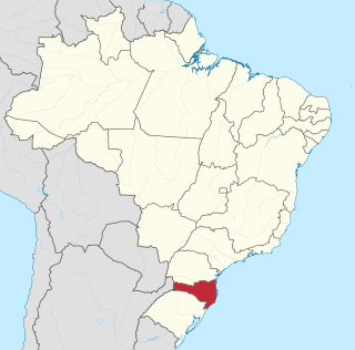
Santa Catarina is a state in the South Region of Brazil. Of Brazil's 26 states, it is the seventh-smallest state in total area and the 11th most populous. Additionally, it is the ninth-largest settlement, with 295 municipalities. The state, with 3.4% of the Brazilian population, generates 3.8% of the national GDP.

Florianópolis is the capital and second largest city of the state of Santa Catarina, in the South region of Brazil. The city encompasses Santa Catarina Island and surrounding small islands, as well as part of the mainland. It has a population of 508,826, according to the 2020 IBGE population estimate, the second-most populous city in the state, and the 47th in Brazil. The metropolitan area has an estimated population of 1,111,702, the 21st largest in the country. The city is known for having the country's third highest Human Development Index score among all Brazilian cities (0.847).

Blumenau is a city in Vale do Itajaí, Santa Catarina state, in the South Region of Brazil, 130 km (81 mi) from the state capital Florianópolis.

Criciúma is a city in the Brazilian state of Santa Catarina. At 28°40′39″S49°22′11″W, it is located 180 km south of Florianópolis, the state capital and around 900 km south of São Paulo. The city is the center of Brazil's flooring and home materials industry, and is the second-largest such center in the world.

Santa Maria is a municipality (município) in the central region of Rio Grande do Sul, the southernmost state of Brazil. In 2020, its population was 283,677 inhabitants in a total area of 1,823 square kilometres (704 sq mi). Santa Maria is the 5th biggest municipality in the state, and the largest in its micro-region.

Canoinhas is a Brazilian municipality, in the north plateau of the State of Santa Catarina. Its latitude is 26°10'38" South, its longitude is 50°23'24" West, and its altitude is 839 meters. The population was estimated in 2020 at 54,480 inhabitants.
Greater São Paulo is a nonspecific term for one of the multiple definitions of the large metropolitan area located in the São Paulo state in Brazil.

Joinville is the largest city in Santa Catarina, in the Southern Region of Brazil. It is the third largest municipality in the southern region of Brazil, after the much larger state capitals of Curitiba and Porto Alegre. Joinville is also a major industrial, financial and commerce center.

Jandaia is a municipality in the eastern portion of the Brazilian state of Goiás.

Itajaí is a municipality in the state of Santa Catarina, Brazil. It is located on the northern central coast of Santa Catarina and is part of the Vale do Itajaí Mesoregion, on the right bank of the Itajaí-Açu river mouth. It lies at the mouth of the Itajaí River, at 20 feet above sea level. The city has the 2nd largest gross domestic product and the highest per capita income in the State of Santa Catarina.

Uarini is a municipality located in the Brazilian state of Amazonas. According to estimates of the Brazilian Institute of Geography and Statistics (IBGE), its population was 13,690 inhabitants in 2020. Its area is 10,246 km2.

Tubarão is a Brazilian municipality located in southern part of Santa Catarina state. The population, according to the IBGE/2020 estimate was 106,422. It is the main city of the Tubarão River basin region, which comprises 20 municipalities and has a population of 350,000.
Agrolândia is a Brazilian municipality in the state of Santa Catarina. It is located in the micro-region of Rio do Sul, with agriculture as its main economic activity. It was colonized by the Germans, who are the main ethnic group. The main access to the municipality is through the SC-426 highway, starting from BR-470. There are secondary accesses through Otacílio Costa, going down the mountain on a gravel road. There are also secondary accesses from the municipality of Braço do Trombudo and through Ituporanga via Atalanta.

Brazil had an official resident population of 203 million in 2022, according to IBGE. Brazil is the seventh most populous country in the world, and the second most populous in the Americas and Western Hemisphere.

São Joaquim is a municipality in the state of Santa Catarina, situated in southern Brazil. Its population in 2020 was 27,139 inhabitants. Located in the Planalto Serrano, it lies 136 km from Tubarão, 81 km from Lages and 227 km from Florianópolis. The town is home to a variety of ethnic groups, including Italian, German, Portuguese, Japanese and Afro-Brazilians. There are also many people from other states in Brazil, especially from Rio Grande do Sul.

Faxinal dos Guedes is a municipality located in the west of the state of Santa Catarina, in the South Region of Brazil. Its population, according to the 2022 Brazilian Institute of Geography and Statistics Census, was 11 192 inhabitants. With an area of 340,070 km², part of its territory is located on the western edge of a meteoritic crater, the Vargeão Dome.

Urupema is a municipality in the state of Santa Catarina in the South region of Brazil. It has an area of approximately 353 km², a population of 2,656 inhabitants as of 2022 and a GDP per capita of R$ 36,058 as of 2021. It is often cited as the coldest city in Brazil.
Balneário Piçarras is a municipality in the state of Santa Catarina in the South region of Brazil.

Osasco is a municipality in São Paulo State, Brazil, located in the Greater São Paulo and ranking 5th in population among São Paulo municipalities. According to the IBGE 2015, Osasco currently has the 9th highest gross domestic product in Brazil, and the 2nd largest in the State of São Paulo. The population is 699,944 in an area of 64.95 km2. It is among the world's more dense cities, similar in density to Tokyo and New York City. It's considered the major urban centre of the Western portion of the Greater São Paulo. It used to be a district of São Paulo City until February 19, 1962, when Osasco became a municipality of its own. The city motto is "Urbs labor", a Latin phrase that means "City work".


