The Belizean Coast mangroves ecoregion covers the brackish and salt-water habitats along the Caribbean Sea coast of Belize, and of Amatique Bay in Guatemala; small parts in the border with Mexico are also present on this ecoregion. The mangroves are partially protected from the open sea by the Belize Barrier Reef, and this ecoregion is distinct from the reef-based Belizean Reef mangroves ecoregion offshore. There is a large population of the vulnerable West Indian manatee in the area. It covers an area of around 2850 km2.

The Amazon–Orinoco–Southern Caribbean mangroves (NT1401) is an ecoregion along the coasts of Colombia, Venezuela, Guyana, Suriname, French Guiana and Brazil.

The Araya and Paria xeric scrub (NT1301) is an ecoregion in Venezuela that stretches along the Caribbean coast to the west of Trinidad, and that includes Margarita Island and some smaller islands. The ecoregion includes dune herbs, dry thorn scrubs and deciduous forests. The mountains on Margarita Island hold montane forests similar to those in the mainland coastal range. The beaches are used for breeding by sea turtles. Some endemic bird species are threatened with extinction by illegal capture for the pet trade. Deforestation and over-grazing by goats are also problems.

The Southern Vietnam lowland dry forests ecoregion covers the low, relatively arid coastal strip of southern Vietnam on the South China Sea. The region is in the rain shadow of the Southern Annamite Range, which blocks humid air from the west. Although approximately half of the ecoregion is forested to some degree, most has at some point been cleared for agriculture or degraded by extraction of hardwoods. There are few protected areas.

The Irrawaddy freshwater swamp forests ecoregion covers the freshwater portion of the delta of the Irrawaddy River, set back an average of 70 km from the Bay of Bengal by the saltwater mangroves. To the north is a rainforest belt with less inundated land. The region is extremely fertile due to the river-borne silt, but nearly-total conversion to agriculture has degraded the ecology. There are no fully protected areas in this ecoregion.

The Southwest Borneo freshwater swamp forests ecoregion covers a number disconnected patches of freshwater swamp forest along the southwestern coasts of Borneo. The swamps are generally set back a few kilometers or two from the sea by the saltwater-affected Sunda Shelf mangroves The relatively fertile, flat soil has led to much of this ecoregion being converted to agriculture.

The Belizean reef mangroves ecoregion covers the mangrove habitats along the islands and cayes of the Belize Barrier Reef. This ecoregion is distinct from the mainland Belizean Coast mangroves ecoregion, and may be considered a sub-unit of the overall Mesoamerican Gulf-Caribbean mangroves ecoregion.

The Coastal Venezuelan mangroves ecoregion covers the salt-water mangrove forests along the Caribbean Sea and Atlantic Ocean coast of Venezuela, from Cocinetas Basin to the edge of the Caño Manamo River and the Orinoco Delta in the east. It is one of the largest mangrove ecoregions in South America, with an area of 5,698 km2, and stretching across over 400 km of Venezuelan coastline.
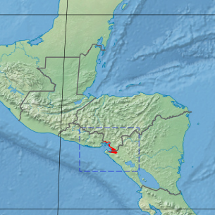
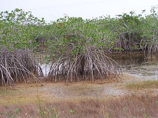
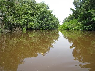
The Gulf of Fonseca mangroves ecoregion covers the brackish mangrove forests around the Gulf of Fonseca on the Pacific Ocean. The Gulf is the meeting point El Salvador, Honduras, and Nicaragua. The Gulf is one of the two primary nesting sites of the critically endangered Hawksbill turtle in the eastern Pacific. In the Honduras portion, there are seven nature reserves that collectively make up a RAMSAR wetland of international importance, providing protection for migratory birds, sea turtle, and fish.
The Magdalena-Santa Marta mangroves ecoregion covers the mangrove forests along the coast of Colombia on the Caribbean Sea, from Gulf of Urabá in the west at the Colombia-Panama border to the Guajira Peninsula in the east. The region is relatively dry, with low precipitation and high evapotranspiration, so the mangroves depend for water and nutrients on the rivers flowing across the estuarine plain from the Sierra Nevada de Santa Marta mountains to the east. Efforts are currently underway to restore mangroves degraded by development and road building from the 1950s to 1980s.

The Petenes mangroves ecoregion covers mangrove habitat along the Gulf of Mexico coast of southern Mexico, where Campeche state and Yucatan state meet, centering on the Celestun Lagoon inland from the barrier-island town of Celestún. Because the region has relatively little rainfall and no rivers feeding the lagoons, the freshwater to support the mangrove ecosystem springs from underground aquifers. The area is important for migratory birds, and as a nesting area for sea turtles. The area around the Celestun Lagoon is protected by the Ría Celestún Biosphere Reserve, a UNESCO Biosphere Reserve, and Los Petenes Biosphere Reserve in Campeche.

The Ría Lagartos mangroves ecoregion covers mangrove habitats of along the northern coast of the Yucatan Peninsula, including the Ria Lagartos Lagoon. A prominent section of the ecoregion is covered by the Ría Lagartos Biosphere Reserve. The site is an important area for migratory birds, fish, and sea turtles.

The Southern Dry Pacific Coast mangroves ecoregion covers a series of mangrove forests along the Pacific Ocean coast of Nicaragua and Costa Rica, from the southern margin of the Gulf of Fonseca to the Gulf of Nicoya near the border with Panama. Because the area is drier than the mangroves further south, evapotranspiration leaves some areas with higher salinity and even salt pans in the internal areas.

The Trinidad mangroves ecoregion covers the separate mangrove forest areas on the coast of the island of Trinidad, in the country of Trinidad and Tobago. The character of the mangroves is affected by the large amount of fresh water flowing out of the Orinoco River and Amazon River to the south, which flow northwest around the island. The mangroves of Trinidad are found on all coasts, and are usually in the estuaries of rivers, but also found in coastal lagoons.

The Usumacinta mangroves ecoregion covers the mangrove forests ont the Gulf Coast of Mexico, around the margins of the Laguna de Términos. The "Ends" in the name refer to the mouths of the rivers that empty into the lagoon, including the Usumacinta River. This region, which is due south of the mouth of the Mississippi River across the Gulf of Mexico, receives an estimated one-third of the wintering birds migrating on the Mississippi Flyway. It is estimated that the lagoon supports 90 endangered species.
The Leeward Islands xeric scrub ecoregion covers the dry ('xeric'), non-forested areas of the Leeward Islands on the northeastern edge of the Caribbean Sea, stretching from the Virgin Islands in the west to Guadeloupe to the southeast. The non-forested areas are generally low scrub shrub, on the low elevations around the peripheries of the islands. Non-forested lower elevations in the region receive less rainfall and are typically semi-arid. A notable feature of the ecoregion is its position in the main hurricane track. The frequent damage to trees allows more pre-climax shrubs and trees to grow. There are a number of endemic species, as in common with islands.

The Trinidad and Tobago moist forests ecoregion covers most of Trinidad Island and Tobago Island near the coast of South America where the southeastern Caribbean Sea meets the Atlantic Ocean. Small portions of the islands around river estuaries and coastal lowlands are mangroves or dry forests. Species diversity is very high, in particular for plants and birds. Tobago, being much smaller, has fewer species.

The Windward Islands xeric scrub ecoregion covers the relatively small areas of the Windward Islands that receive low levels of precipitation. The dry areas of these islands are the low coastal areas that receive less precipitation. Because the dry scrub land is generally flat, near the coast, and not as obviously in need of conservation as the upland forests of the interior, they are more vulnerable to human settlement and development for agriculture.

The Cayman Islands dry forests ecoregion covers about half of the Cayman Islands in the Caribbean Sea. The other half of the low-lying islands are mangroves. The dry forests of Grand Cayman have been heavily cleared or degraded for human development; the less populated islands have more intact wooded habitat.

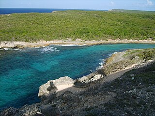
The Aruba-Curaçao-Bonaire cactus scrub ecoregion covers the dry land on the semi-arid islands of Aruba, Curaçao, and Bonaire in the southern Caribbean Sea, about 80 km from the mainland of Venezuela. In low-lying coastal areas the islands also support mangrove wetlands. The landscape features a range of cactus species and acacia trees.

