
Honduras, officially the Republic of Honduras, is a country in Central America. Honduras is bordered to the west by Guatemala, to the southwest by El Salvador, to the southeast by Nicaragua, to the south by the Pacific Ocean at the Gulf of Fonseca, and to the north by the Gulf of Honduras, a large inlet of the Caribbean Sea. Its capital and largest city is Tegucigalpa.

St. George's Caye is an island in the Caribbean Sea, eight miles east of Belize City. It is part of the Belize District of Belize, Central America. The village on the island is also known as St. George's Caye. As of 2000, St. George's Caye had a permanent population of about 20 people.

Villa Clara is one of the provinces of Cuba. It is located in the central region of the island bordering on the Atlantic Ocean to the north, Matanzas Province to the west, Sancti Spiritus Province to the east, and Cienfuegos Province to the South. Villa Clara shares with Cienfuegos and Sancti Spiritus on the south the Escambray Mountain Range. Its main cities are Santa Clara, Remedios, Sagua La Grande, Camajuani, Caibarién, Ranchuelo, Placetas, and Manicaragua.

The Archipelago of San Andrés, Providencia and Santa Catalina, or San Andrés and Providencia, is one of the departments of Colombia, and the only one located geographically in Central America. It consists of two island groups in the Caribbean Sea about 775 km northwest of mainland Colombia, and eight outlying banks and reefs. The largest island of the archipelago and Colombia is called San Andrés and its capital is San Andrés. The other large islands are Providencia and Santa Catalina Islands which lie to the north-east of San Andrés; their capital is Santa Isabel.

Serranilla Bank is a partially submerged reef, with small uninhabited islets, in the western Caribbean Sea. It is situated about 350 kilometres (220 mi) northeast of Punta Gorda, Nicaragua, and roughly 280 kilometres (170 mi) southwest of Jamaica. The closest neighbouring land feature is Bajo Nuevo Bank, located 110 kilometres (68 mi) to the east.

Bajo Nuevo Bank, also known as the Petrel Islands, is a small, uninhabited reef with some small grass-covered islets, located in the western Caribbean Sea at 15°53′N78°38′W, with a lighthouse on Low Cay at 15°51′N78°38′W. The closest neighbouring land feature is Serranilla Bank, located 110 kilometres to the west.

The Ernst Thälmann Island is a 15 km (9.3 mi) long and 500 m (1,600 ft) wide island in the Gulf of Cazones that is named after Ernst Thälmann, a German communist politician. During a 1970s state visit to the German Democratic Republic (GDR), Fidel Castro made a promise that Cuba would donate an island to the East German government, and Cayo Blanco del Sur was renamed in a ceremony during a state visit by Erich Honecker. But after the reunification of Germany, when a German newspaper tried to visit the island, they were told this transfer had only been "symbolic".

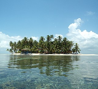
The Cayos Cochinos or Cochinos Cays consist of two small islands and 13 smaller coral cays situated 30 kilometres (19 mi) northeast of La Ceiba on the northern shores of Honduras. Although geographically separate, they belong to the Bay Islands department and are part of the Roatán municipality. The population numbered 108 at the 2001 census. The total land area measures about 2 km2 (0.8 sq mi).
Cayo Sabinal is a cay on the northern coast of Cuba, in the municipality of Nuevitas, Camagüey Province. Has an area of 335 km².

Quita Sueño Bank is a reef formation of Colombia which was once claimed by the United States, located 110 km north-northeast of Providencia Island.

The Miskito Cays are an archipelago with an area of 27 km2 located off shore in the northeastern Caribbean coast of Nicaragua, part of the North Caribbean Coast Autonomous Region. The Miskito Cays are composed of 76 formations that include estuaries, coral reefs, cays, seagrass beds, and islets, of which 12 of the formations are covered with vegetation and consequently form islands which are lined with white sand beaches.
The Pearl Cays is a group of 18 cays located about 35 km (22 mi) from Pearl Lagoon off the Caribbean coast of Nicaragua. They are part of the South Caribbean Coast Autonomous Region. The Pearl Cays are covered with tropical vegetation and are lined with white sandy beaches. They are an important nesting site for turtles, including the critically endangered Hawksbill turtle.

San Andrés is a coral island in the Caribbean Sea. Politically part of Colombia, and historically tied to the United Kingdom, San Andrés and the nearby islands of Providencia and Santa Catalina form the department of San Andrés, Providencia and Santa Catalina. San Andrés, in the southern group of islands, is the largest of Colombia. The official languages of the department are Spanish, English, and San Andrés–Providencia Creole.

The Elbow Cays are uninhabited cays in the Cay Sal Bank, Bahamas. It is the most Western point in the Bahamas. They are part of a reef shelf located at the northwestern end of the bank about 80 km (50 mi) off the Cuban coast and 130 km (80 mi) southeast of Key West, Florida. These cays are an excellent scuba diving spot.
Calala Island is a private island located in the Caribbean Sea, forming part of an archipelago of islands known as the Pearl Cays, off the coast of Nicaragua.
Bobel Cay is an island in Honduras, located around 500km off the east coast of the South American continent.