Cayo de Agua

Last updated
Cayo de Agua
Cayo de Agua, Archipielago de Los Roques, Venezuela.jpg
Cayo de Agua Island
Venezuela relief location map (+claimed).jpg
Red pog.svg
Cayo de Agua
La2-demis-caribbean.png
Red pog.svg
Cayo de Agua
Geography
Location Lesser Antilles
Caribbean Sea
Coordinates 11°49′33″N66°56′34″W / 11.82583°N 66.94278°W / 11.82583; -66.94278
Archipelago Los Roques
Area0.69 km2 (0.27 sq mi)
Length8.3 km (5.16 mi)
Highest elevation6 m (20 ft)
Administration
Federal Entity Federal dependencies of Venezuela

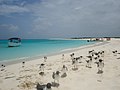
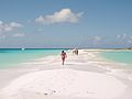
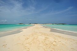
Cayo de Agua [1] [2] (in English literally Water Key) is the name of an island in the eastern Caribbean Sea [3] that geographically belongs to the Los Roques Archipelago [4] [5] and is administratively organized as part of the Federal Dependencies, Venezuela, [6] in addition to being part of the National Park of the same name and the Miranda Island Territory, the name of this key has its origin in the fact that it has freshwater wells within it.

Contents

Location

It is located to the north of Venezuela, in the extreme west of the National Park "Los Roques", by the north they limit with the keys of Puntas de Cocos, Pelona de Cayo de Agua, Bequevé and Selesquí, and by the southeast they are the cayos Dos Mosquises. Cayo de Agua is located relatively far from the aerodrome or airport of Los Roques located at the opposite end (west) of the archipelago on the island of Gran Roque.

Tourism

Cayo de Agua is popular within the archipelago thanks to the beauty of its white sands and solitary beaches, the birds that can be found in its surroundings and the fact that it forms with other neighboring keys a small natural swimming pool, there are also freshwater wells, one of the most practiced activities is diving.

See also

Related Research Articles

<span class="mw-page-title-main">Canary Islands</span> Spanish archipelago and region in the Atlantic Ocean

The Canary Islands, also known informally as the Canaries, are a Spanish autonomous community and archipelago in Macaronesia in the Atlantic Ocean. At their closest point to the African mainland, they are 100 kilometres west of Morocco and the Western Sahara. They are the southernmost of the autonomous communities of Spain. The islands have a population of 2.2 million people and are the most populous special territory of the European Union.

<span class="mw-page-title-main">Index of Puerto Rico–related articles</span>

The following is an alphabetical list of articles related to the Commonwealth of Puerto Rico.

<span class="mw-page-title-main">Federal Dependencies of Venezuela</span> Administrative division of Venezuela

The Federal Dependencies of Venezuela encompass most of Venezuela's offshore islands in the Caribbean Sea and the Gulf of Venezuela, excluding those islands that form the State of Nueva Esparta and some Caribbean coastal islands that are integrated with nearby states. These islands, with a total area of 342 square kilometres, are sparsely populated – according to the preliminary results of the 2011 Census only 2,155 people live there permanently, with another hundred from Margarita Island who live there seasonally to engage in fishing. Local government is officially under the authority of Central government in Caracas, although de facto power is often held by the heads of the sparse and somewhat isolated communities that decorate the territories.

<span class="mw-page-title-main">La Orchila Island</span> Island of the Federal Dependencies of Venezuela

La Orchila Island is an island and a military base off the coast of Venezuela, north of Caracas. It has numerous beaches, including one where the sand is markedly pink.

<span class="mw-page-title-main">Index of Venezuela-related articles</span>

The following is an alphabetical list of topics related to Venezuela.

<span class="mw-page-title-main">Los Roques Archipelago</span> Federal dependency of Venezuela

The Los Roques Archipelago is a federal dependency of Venezuela consisting of approximately 350 islands, cays, and islets in a total area of 40.61 square kilometers. The archipelago is located 128 kilometers (80 mi) directly north of the port of La Guaira, in the Caribbean Sea.

<span class="mw-page-title-main">La Tortuga Island</span> Federal dependency of Venezuela

La Tortuga Island is an uninhabited island of Venezuela, the largest in the Federal Dependencies of Venezuela. It is part of a group of islands that include the Tortuguillos and Cayo Herradura. Isla La Tortuga has an area of 156 km2 (60 sq mi).

Canarreos Archipelago is an archipelago of Cuba.

<span class="mw-page-title-main">Las Aves Archipelago</span> Federal dependency of Venezuela

The Las Aves Archipelago is a pristine archipelago in the Caribbean Sea, and is part of the Federal Dependencies of Venezuela. It is located north of the Venezuelan states of Aragua and Carabobo, between the Dutch island Bonaire in the west, and the Los Roques Archipelago in the east, at 12°00′N67°40′W. The prime economic importance of the islands lies in fishing. "Las Aves" translates to "The Birds" in English.

<span class="mw-page-title-main">Insular Region, Venezuela</span> Geographic/Natural and Administrative Region in Nueva Esparta, Venezuela

The Insular Region is one of the eight natural regions of Venezuela and one of the 10 administrative regions in which Venezuela was divided for its development plans; it comprises all of the nation's islands, and is formed by the state of Nueva Esparta and the Federal Dependencies.

<span class="mw-page-title-main">Index of Cuba-related articles</span>

The following is an alphabetical list of topics related to Cuba.

<span class="mw-page-title-main">Los Testigos Islands</span>

Los Testigos Islands are a group of islands in the southeastern Caribbean Sea. They are a part of the Dependencias Federales of Venezuela.

<span class="mw-page-title-main">Bocas del Toro Archipelago</span>

The Bocas del Toro Archipelago is a group of islands in the Caribbean Sea in the northwest of Panama. The archipelago separates Almirante Bay and Chiriquí Lagoon from the open Caribbean Sea. The archipelago is part of the Bocas del Toro District which is part of Bocas del Toro Province. The major city is Bocas del Toro, also called Bocas Town, on Isla Colón. The islands are accessible by water taxis and private boats. Isla Colón is accessible by airplanes, ferries, private boats, and water taxis. Bocas del Toro "Isla Colón" International Airport, located just west of Bocas Town, provides air transportation to and from the islands. Ferries serve Bocas Town from Almirante, Changuinola, and Chiriquí Grande.

<span class="mw-page-title-main">Gran Roque</span> Island in the archipelago of Los Roques; federal dependency of Venezuela

Gran Roque is an island, one of the federal dependencies of Venezuela, located in the southeastern Caribbean Sea in the archipelago of Los Roques, which has 1.7 km2 in extent, where the majority of the population lives. The airport is located by the sea, a few meters from the beach.

<span class="mw-page-title-main">Elbow Cays</span> Cays in The Bahamas

The Elbow Cays are uninhabited cays in the Cay Sal Bank, Bahamas. It is the most Western point in the Bahamas. They are part of a reef shelf located at the northwestern end of the bank about 80 km (50 mi) off the Cuban coast and 130 km (80 mi) southeast of Key West, Florida. These cays are an excellent scuba diving spot.

<span class="mw-page-title-main">Cayos Francisquí</span> Caribbean cays

The Cayos Francisquí also known as Cayos Franciskí, is the name of a group of Caribbean cays that form part of the Los Roques Archipelago National Park in northern Venezuela. Administratively, as part of the Los Roques Archipelago, they belong to the Francisco de Miranda Island Territory.

<span class="mw-page-title-main">Madrisquí</span>

Madrisquí is a small island that belongs to the Archipelago of Los Roques, which is administratively part of the Federal Dependencies and is under the authority of the Miranda Island Territory in the waters of the Caribbean Sea of Venezuela. Is part of the tourist or recreational area of the park, is linked to Cayo Pirata through a narrow sand barrier. It has an area of 18.85 hectares.

<span class="mw-page-title-main">Cayos Bequevé</span> Venezuelan islands in the Caribbean Sea

Cayos Bequevé is the name given to a group of Venezuelan islands in the southeast of the Caribbean Sea that is part of the Los Roques Archipelago, and of the Lesser Antilles that is administered as part of the Federal Dependencies of Venezuela and the National Park Archipelago of Los Roques, and is also part of the so-called Miranda Island Territory. Not to be confused with an inn of the same name but located on the island of Gran Roque.

<span class="mw-page-title-main">Dos Mosquises</span>

Dos Mosquises are two islands that form part of the Los Roques archipelago, are administratively part of the Francisco de Miranda Island Territory, and are located in the Lesser Antilles in the Caribbean Sea.

References

  1. Casanova, Katiusa (2016-08-04). "Cayo de Agua en Los Roques". Noticias.com.ve (in European Spanish). Retrieved 2019-11-23.
  2. "Cosas del Caribe » Turismo en Isla Cayo de Agua (Los Roques, Venezuela)Cosas del Caribe". Cosas del Caribe (in Spanish). Retrieved 2019-11-23.
  3. Antczak, María Magdalena; Antczak, Andrzej T. (2006). Los ídolos de las islas prometidas: arqueología prehispánica del archipiélago de los Roques (in Spanish). Equinoccio. ISBN   978-980-237-236-2.
  4. "VenezuelaTuya". Venezuela Tuya. Retrieved 2019-11-23.
  5. Brushaber, Susan; Greenberg, Arnold (October 1997). Venezuela Alive. Hunter Publishing, Inc. ISBN   978-1-55650-800-4.
  6. "Cayo de Agua". Tierra de Gracia (in Spanish). 2015-10-01. Retrieved 2019-11-23.