
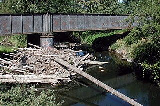
Multnomah Falls is a waterfall located on Multnomah Creek in the Columbia River Gorge, east of Troutdale, between Corbett and Dodson, Oregon, United States. The waterfall is accessible from the Historic Columbia River Highway and Interstate 84. Spanning two tiers on basalt cliffs, it is the tallest waterfall in the state of Oregon at 620 ft (189 m) in height. The Multnomah Creek Bridge, built in 1914, crosses below the falls, and is listed on the National Register of Historic Places.

The Kennebec River is a 170-mile-long (270 km) river within the U.S. state of Maine. It rises in Moosehead Lake in west-central Maine. The East and West Outlets join at Indian Pond and the river flows southward. Harris Station Dam, the largest hydroelectric dam in the state, was constructed near that confluence. The river is joined at The Forks by its tributary the Dead River, also called the West Branch.

Toketee Falls is a waterfall in Douglas County, Oregon, United States, on the North Umpqua River at its confluence with the Clearwater River. It is located approximately 58 miles (93 km) east of Roseburg near Oregon Route 138.

The Eastbank Esplanade is a pedestrian and bicycle path along the east shore of the Willamette River in Portland, Oregon, United States. Running through the Kerns, Buckman, and Hosford-Abernethy neighborhoods, it was conceived as an urban renewal project to rebuild the Interstate 5 bicycle bypass washed out by the Willamette Valley Flood of 1996. It was renamed for former Portland mayor Vera Katz in November 2004 and features a statue of her near the Hawthorne Bridge.

Shepperd's Dell is a small canyon in the Columbia River Gorge in Oregon, located at 45.54833°N 122.195°W which is less than one-third mile southeast of Rooster Rock State Park. The Shepperd's Dell Bridge is listed on the National Register of Historic Places.

Foster Dam is an embankment type rock-fill dam across the South Santiam River near Sweet Home, Oregon, United States.
Abiqua Creek is a tributary of the Pudding River in the U.S. state of Oregon. The creek originates near Lookout Mountain in the foothills of the Cascade Range in the northwestern part of the state. It flows northwest for about 29 miles (47 km) to its confluence with the Pudding, about 2 miles (3.2 km) west of Silverton, in the Willamette Valley. About 20 miles (32 km) north of Silverton, the Pudding River meets the Molalla River, which meets the Willamette River less than 1 mile (1.6 km) later near Canby.

Lost Creek Lake is a reservoir located on the Rogue River in Jackson County, Oregon, United States. The lake is impounded by William L. Jess Dam which was constructed by the U.S. Army Corps of Engineers in 1977 for flood control and fisheries enhancement. The lake and dam were the first completed elements of the multi-purpose Rogue River Basin Project, consisting of Lost Creek Lake, Applegate Lake and the Elk Creek project. The lake is located approximately 27 miles (43 km) northeast of Medford.

Dorena is an unincorporated community in Lane County, Oregon, United States. It is located southeast of Cottage Grove on the Row River, a tributary of the Coast Fork Willamette River.

The 40-Mile Loop is a partially completed greenway trail around and through Portland in the U.S. state of Oregon. It was proposed in 1903 by the Olmsted Brothers architecture firm as part of the development of Forest Park. One greenway expert calls it "one of the most creative and resourceful greenway projects in the country."

Blue Lake Regional Park is a public park in Fairview, in the U.S. state of Oregon. The 101-acre (41 ha) park, near the south shore of the Columbia River in Multnomah County, includes many covered and uncovered picnic areas, playing fields for sports such as softball, a cross country course and infrastructure related to lake recreation including swimming, boating, and fishing. Encompassing wooded areas, three ponds, and a wetland in addition to the lake, the park is frequented by migrating birds and other wildlife. Paved paths run through the park, which is near the 40-Mile Loop hiking and biking trail. Park vegetation includes cottonwoods, willows, and other trees and shrubs as well as wetland plants such as cattails.

Cazadero is an unincorporated historic locale in Clackamas County, Oregon, United States. Cazadero was a station on the Estacada interurban railway line of the Portland Railway, Light and Power Company (PRL&P) and later Portland Electric Power Company (PEPCO), near where the power plant of the PEPCO-owned Cazadero Dam was located on the Clackamas River.

McCredie Springs are hot springs and a former resort in Lane County, Oregon, United States. It is located near Oregon Route 58, 10.7 miles (17.2 km) east of Oakridge, and 50.7 miles (81.6 km) east of Eugene, within the Willamette National Forest. It is known for the nearby natural hot springs along Salt Creek.
Tonquin is an unincorporated locale in Washington County, Oregon, United States.

Blue River Reservoir is an artificial impoundment, about 6 miles (10 km) long, of the Blue River in Lane County in the U.S. state of Oregon. The reservoir is about 1 mile (1.6 km) north of Oregon Route 126 in the Willamette National Forest about 45 miles (72 km) east of Eugene.
Dodson is an unincorporated community in Multnomah County, Oregon, United States. It is located about 4½ miles (7.2 km) east of Multnomah Falls and one mile west of Warrendale, in the Columbia River Gorge on Interstate 84/U.S. Route 30. It is across the Columbia River from Skamania, Washington. Dodson is within the Cascade Locks ZIP code.

Warrendale is an unincorporated community in Multnomah County, Oregon, United States. It is located about a mile east of Dodson and about 3 miles (4.8 km) west of Bonneville in the Columbia River Gorge on Interstate 84/U.S. Route 30. It is across the Columbia River from Beacon Rock. The community was the site of an important salmon cannery founded in the 1870s.
The Cazadero Trail is a multi-use trail in the U.S. state of Oregon in a rural area of southeastern Portland.
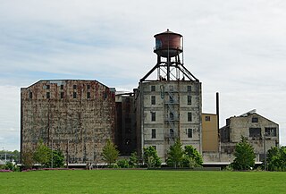
The Centennial Mills, originally known as the Crown Mills, is a complex of twelve buildings along the Willamette River in Portland, Oregon's Pearl District, in the United States. The Portland Development Commission has owned Centennial Mills since 2000. The buildings are slated for demolition, except for the flour and feed mill buildings. Between Summer 2015 and Fall 2016, most of the buildings on the property was demolished.
The Burnside Bridgehead is a development project at the northeast end of the Burnside Bridge in Portland, Oregon's Kerns neighborhood, in the United States.

