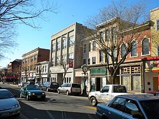
U.S. Route 9 is a north–south United States highway in the states of Delaware, New Jersey, and New York in the United States. It is one of only two U.S. Highways with a ferry connection ; the other is US 10. US 9 is signed east–west in Delaware and north–south on the rest of its route. The southern terminus of the route is in Laurel, Delaware, at an intersection with U.S. Route 13, while the highway's northern terminus is at a junction with Interstate 87 in Champlain, New York, where the roadway continues north as the unsigned NY 971B, which ends in a cul-de-sac just short of the Canada–US border. The highway is mentioned in the Bruce Springsteen songs "Born to Run" and "The Promise", "My Geraldine Lies Over the Delaware" by The Wonder Years (band) and "The Devil On Hwy 9" by Danzig (band). The highway, particularly the section around Freehold, New Jersey, is associated with Springsteen more generally.
Cedar Creek may refer to:

Tulpehocken Creek is a 39.5-mile-long (63.6 km) tributary of the Schuylkill River in southeastern Pennsylvania in the United States, and during the American Canal Age, once provided nearly half the length of the Union Canal linking the port of Philadelphia, the largest American city and the other communities of Delaware Valley with the Susquehanna basin and the Pennsylvania Canal System connecting the Eastern seaboard to Lake Erie and the new settlements of the Northwest Territory via the Allegheny}, Monongahela. and Ohio Rivers at Pittsburgh.

The Maurice River is a tributary of Delaware Bay in Salem County and Cumberland County, New Jersey in the United States. The river was named for Maurice, Prince of Orange.

The Cohansey River is a 30.6-mile-long (49.2 km) river in southern New Jersey in the United States. The river drains approximately 108 square miles (280 km2) of rural agricultural and forested lowlands on the north shore of Delaware Bay.
The St. Jones River is a river flowing to Delaware Bay in central Delaware in the United States. It is 12.8 miles (20.6 km) long and drains an area of 36 square miles (93 km2) on the Atlantic Coastal Plain. The river is believed to have been named either for Robert Jones, an early European property owner in the region, or for "St. Jone", the Welsh spelling of St. John.
Raccoon Creek is a 22.6-mile-long (36.4 km) tributary of the Delaware River in southern New Jersey in the United States.
A 1950s proposal to construct a dam near Tocks Island across the Delaware River was met with considerable controversy and protest. Tocks Island is located in the Delaware River a short distance north from the Delaware Water Gap. In order to control damaging flooding and provide clean water to supply New York City and Philadelphia, the U.S. Army Corps of Engineers proposed building a dam. When completed, the Tocks Island Dam would have created a 37-mile (60-km) long lake between Pennsylvania and New Jersey, with depths of up to 140 feet. This lake and the land surrounding were to be organized as the Tocks Island National Recreation Area. Although the dam was never built, 72,000 acres (291 km²) of land were acquired by condemnation and eminent domain. This incited environmental protesters and embittered local residents displaced by the project's preparations when their property was condemned. After the Tocks Island Dam project was withdrawn, the lands acquired were transferred to the oversight of the National Park Service which reorganized them to establish the Delaware Water Gap National Recreation Area.

Alloway Creek is a 23.2-mile-long (37.3 km) tributary of the Delaware River in Salem County, New Jersey in the United States. The name is a derivative of Allowas, an Indian chief. It has also been known by other names: Aloes River, Aloes Creek, Cotton River, Korten River, Short River, Monmouth River, Munmouth River, and Roiter's River.
Stow Creek is an 18.0-mile-long (29.0 km) tributary of Delaware Bay in Salem and Cumberland counties, New Jersey in the United States.
Back Creek is an estuary of Delaware Bay in Cumberland County, New Jersey in the United States.
Nantuxent Creek is a 5.5-mile-long (8.9 km) estuary of Delaware Bay in Cumberland County, New Jersey in the United States.
West Creek is a 12.3-mile-long (19.8 km) tributary of Delaware Bay in Cape May County, New Jersey in the United States.
East Creek is a 4.8-mile-long (7.7 km) tributary of Delaware Bay in Cape May County, New Jersey in the United States.
Dennis Creek is an 8.8-mile-long (14.2 km) tributary of Delaware Bay in Cape May County, New Jersey in the United States.
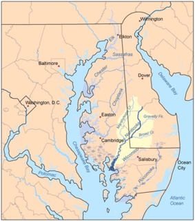
The Nanticoke River is a tributary of the Chesapeake Bay on the Delmarva Peninsula. It rises in southern Kent County, Delaware, flows through Sussex County, Delaware, and forms the boundary between Dorchester County, Maryland and Wicomico County, Maryland. The tidal river course proceeds southwest into the Tangier Sound, Chesapeake Bay. The river is 64.3 miles (103.5 km) long. A 26-mile ecotourism water trail running along the River was set aside in July 2011 by Delaware state and federal officials, contiguous with a 37-mile water-trail extending through Maryland to the Chesapeake Bay.

Ridley Creek State Park is a 2,606-acre (1,055 ha) Pennsylvania state park in Edgmont, Middletown and Upper Providence Townships, Delaware County, Pennsylvania in the United States. The park, about 5 miles (8 km) north of the county seat of Media, offers many recreational activities, such as hiking, biking, fishing, and picnicking. Ridley Creek passes through the park. Highlights include a 5-mile (8 km) paved multi-use trail, a formal garden designed by the Olmsted Brothers, and Colonial Pennsylvania Plantation, which recreates daily life on a pre-Revolutionary farm. The park is adjacent to the John J. Tyler Arboretum. Ridley Creek State Park is just over 16 miles (26 km) from downtown, Philadelphia between Pennsylvania Route 352 and Pennsylvania Route 252 on Gradyville Road.

Marsh Creek State Park is a 1,705 acres (690 ha) Pennsylvania state park in Upper Uwchlan and Wallace Townships, Chester County, Pennsylvania in the United States. The park is the location of the 535-acre (217 ha) man-made Marsh Creek Lake. With an average depth of 40 feet, the lake is stocked with fish and is a stop for migrating waterfowl. Marsh Creek State Park is 2 miles (3.2 km) west of Eagle on Pennsylvania Route 100. Park road hours 8:00 am until sunset. All other access open 24 hours.

Neepaulakating Creek is a 2.4-mile long (3.8 km) tributary of Papakating Creek in Wantage Township in Sussex County, New Jersey in the United States. It is one of three streams feeding the Papakating Creek, a major contributor to the Wallkill River. Although the stream was dammed in the 1950s to create Lake Neepaulin as the focal point of a private residential development, the stream did not receive a name until 2002. Residents chose a name that combined elements of the names "Neepaulin" and "Papakating", and submitted a proposal to the United States Board of Geographic Names. The name was approved in 2004.