
Trinidad and Tobago is an archipelagic republic in the southern Caribbean between the Caribbean Sea and the North Atlantic Ocean, northeast of Venezuela. They are southeasterly islands of the Lesser Antilles, Monos, Huevos, Gaspar Grande, Little Tobago, and St. Giles Island. Trinidad is 11 km (6.8 mi) off the northeast coast of Venezuela and 130 km (81 mi) south of the Grenadines. The island measures 4,768 km2 (1,841 sq mi) in area with an average length of 80 km (50 mi) and an average width of 59 km (37 mi). The island appears rectangular in shape with three projecting peninsular corners. Tobago is 30 km (19 mi) northeast of Trinidad and measures about 298 km2 (115 sq mi) in area, or 5.8% of the country's area, 41 km (25.5 mi) in length and 12 km (7.5 mi) at its greatest width. The island is cigar-shaped in appearance, with a northeast–southwest alignment.

Port of Spain, officially the City of Port of Spain, is the capital of Trinidad and Tobago and the third largest municipality, after Chaguanas and San Fernando. The city has a municipal population of 37,074, an urban population of 81,142 and a transient daily population of 250,000. It is located on the Gulf of Paria, on the northwest coast of the island of Trinidad and is part of a larger conurbation stretching from Chaguaramas in the west to Arima in the east with an estimated population of 600,000.

Petropavlovsk-Kamchatskiy is a city and the administrative, industrial, scientific, and cultural center of Kamchatka Krai, Russia. Its population is 179,780.

Scarborough is a major city of the Island of Tobago as well as the eleventh-most-populous in Trinidad and Tobago. Scarborough was the capital of Tobago in 1769 before it was unified with Trinidad changing the capital to Port of Spain. Situated in western Tobago, Scarborough is the economic and cultural centre of the island of Tobago. The estimated population in 2011 was 17,537. Scarborough is ranked as one of Trinidad and Tobago's most densely populated towns alongside Port of Spain, San Fernando, Chaguanas and Arima. The city's skyline is dominated by Fort King George, an 18th-century fortification named after King George III, which now hosts a historic and archaeologic museum. Scarborough's deepwater harbour was built in 1991; before that ships were forced to anchor offshore.
Princes Town is a town within the Princes Town Regional Corporation, located on southern Trinidad island in Trinidad and Tobago. The population of the town is 28,335.
Couva is an urban town in west-central Trinidad, south of Port of Spain and Chaguanas and north of San Fernando and Point Fortin. It is the capital and main urban centre of Couva–Tabaquite–Talparo, and the Greater Couva area includes the Point Lisas Industrial Estate and the Port of Point Lisas. It is one of the fastest-growing towns in the country. Couva's southern boundary is at the village of California & Point Lisas, and to the north Couva stretches to McBean. To the east of Couva is Preysal. To the west of Couva is the road to Waterloo and Carli Bay, which are located on the Gulf of Paria. Couva was part of the Caroni County. Couva is considered a major power base for the United National Congress (UNC), whose headquarters was previously located here.

Diego Martin is a town and is the urban commercial center and capital of the Diego Martin region in Trinidad and Tobago. Its location in the region is just on the south eastern border, west of the capital city of Port of Spain and east of the town of Carenage. Diego Martin town in the Northern Range was once filled with a number of small valleys but is now a densely populated area. It was named after a Spanish explorer Don Diego Martín. The area was settled by French planters and their slaves in the 1780s. It consists of a cluster of communities including Congo Village, Diamond Vale, Green Hill, Patna Village, Petit Valley, Blue Range, La Puerta Avenue, Four Roads, Rich Plain, River Estate, Blue Basin, Water Wheel, West Moorings, Bagatelle and Sierra Leone.

Washington, D.C., in the United States, is located at 38°53′42″N77°02′11″W. According to the United States Census Bureau, the city has a geographical area of 68.3 square miles (176.9 km2), 61.4 square miles (159.0 km2) of which is land, and the remaining 6.9 square miles (17.9 km2) (10.16%) of which is water.

UTC−04:00 is an identifier for a time offset from UTC of −04:00. It is observed in the Eastern Time Zone during the warm months of daylight saving time, as Eastern Daylight Time. The Atlantic Time Zone observes it during standard time . It is observed all year in the Eastern Caribbean and several South American countries.
Doda is a town and a notified area committee in Doda district in the Indian union territory of Jammu and Kashmir. Doda has an average elevation of 1,107 metres (3,632 ft).
Milwaukee has a humid continental climate, with four distinct seasons and wide variations in temperature and precipitation in short periods of time. The city's climate is also strongly influenced by nearby Lake Michigan, which creates two varying climates within the Milwaukee area. The Urban heat island effect also plays a role in the city's climate, insulating it from winter cold, but keeping it cooler in spring and summer.

The City and County of Denver, Colorado, is located at 39°43'35" North, 104°57'56" West in the Colorado Front Range region. The Southern Rocky Mountains lie to the west of Denver and the High Plains lie to the east.
Port Walter is located on the southeastern side of Baranof Island in Sitka City and Borough, Alaska. It is made up of two parts: Little Port Walter and Big Port Walter.

Viluppuram, Villupuram, or Vizhuppuram is a Municipality and the administrative headquarters of Viluppuram district.
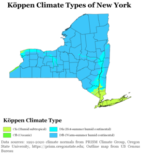
The climate of New York state is generally humid continental, while the extreme southeastern portion of the state lies in the warmer humid subtropical climate zone. Winter temperatures average below freezing during January and February in much of New York state, but several degrees above freezing along the Atlantic coastline, including New York City.

The climate of Los Angeles is mild to hot year-round, and mostly dry. It is classified as a Mediterranean climate, which is a type of dry subtropical climate. It is characterized by seasonal changes in rainfall—with a dry summer and a winter rainy season. Under the modified Köppen climate classification, the coastal areas are classified as Csb, and the inland areas as Csa.

The climate of New Jersey classification of New Jersey is humid subtropical in South Jersey with a continental climate in North Jersey, particularly in the northwestern area of the state. The northwest part of New Jersey is the snowiest due to the higher elevations that earn it a Dfb classification. During the winters, New Jersey can experience Nor'easters, which are snowstorms that affect the Northeastern United States, and Atlantic Canada. However, many would-be snow events in the state end up turning to rain due to warm ocean air being brought in by the storm. New Jersey's climate is shaped by its proximity to the Atlantic Ocean which provides moisture and moderates temperatures.
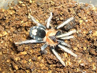
Cyriocosmus elegans is a spider species in the genus Cyriocosmus and the family Theraphosidae (tarantulas) found in Venezuela, Trinidad and Tobago.
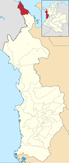
Sapzurro is a small town on the Caribbean Sea located in the northwest corner of the Republic of Colombia. It is part of the Municipality of Acandí, in the Chocó Department of the Darién region. The closest city is Capurganá, a semi-popular port town, and it is across the international boundary from the Panamanian town of La Miel.

The Trinidad and Tobago moist forests ecoregion covers most of Trinidad Island and Tobago Island near the coast of South America where the southeastern Caribbean Sea meets the Atlantic Ocean. Small portions of the islands around river estuaries and coastal lowlands are mangroves or dry forests. Species diversity is very high, in particular for plants and birds. Tobago, being much smaller, has fewer species.
