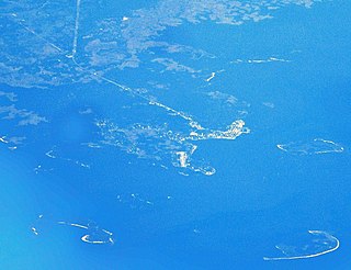
Cedar Key is a city in Levy County, Florida, United States. The population was 702 at the 2010 census. The Cedar Keys are a cluster of islands near the mainland. Most of the developed area of the city has been on Way Key since the end of the 19th century. The Cedar Keys are named for the eastern red cedar Juniperus virginiana, once abundant in the area.

Cedar Rapids is the second-largest city in Iowa, United States and is the county seat of Linn County. The city lies on both banks of the Cedar River, 20 miles (32 km) north of Iowa City and 100 miles (160 km) northeast of Des Moines, the state's capital and largest city. It is a part of the Cedar Rapids/Iowa City region of Eastern Iowa, which includes Linn, Benton, Cedar, Iowa, Jones, Johnson, and Washington counties.

Harvey Cedars is a borough in Ocean County, New Jersey, United States. As of the 2010 United States Census, the borough's population was 337, reflecting a decline of 22 (−6.1%) from the 359 counted in the 2000 Census, which had in turn declined by 3 (−0.8%) from the 362 counted in the 1990 Census. The borough borders the Atlantic Ocean on Long Beach Island.

Cedar City is the largest city in Iron County, Utah, United States. It is located 250 miles (400 km) south of Salt Lake City, and 170 miles (270 km) north of Las Vegas on Interstate 15. It is the home of Southern Utah University, the Utah Shakespeare Festival, the Utah Summer Games, the Simon Fest Theatre Co., and other events. As of the 2010 census the city had a population of 28,857, up from 20,257 in 2000. As of 2019, the estimated population was 34,764.
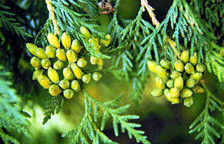
Thuja occidentalis, also known as northern white-cedar, eastern white-cedar, or arborvitae, is an evergreen coniferous tree, in the cypress family Cupressaceae, which is native to eastern Canada and much of the north-central and northeastern United States. It is widely cultivated as an ornamental plant.
Cedar Island State Park is a 10-acre (4.0 ha) state park located in the Town of Hammond in St. Lawrence County, New York. The park comprises half of Cedar Island, located in Chippewa Bay in the St. Lawrence River, part of the Thousand Islands region. The remainder of the island is privately owned.
National Military Park, National Battlefield, National Battlefield Park, and National Battlefield Site are four designations for 25 battle sites preserved by the United States federal government because of their national importance. The designation applies to "sites where historic battles were fought on American soil during the armed conflicts that shaped the growth and development of the United States...."

The Cedar Key Light is located on Seahorse Key across the harbor from Cedar Key, Florida. Seahorse Key was the site a watchtower erected in 1801 by followers of William Augustus Bowles, self-designated Director General of the State of Muskogee, an attempt to set up an independent state in the western part of East Florida. The watchtower was destroyed by a Spanish naval force in 1802. Seahorse Key was used as a detention center for Seminoles captured in the Second Seminole War (1835–1842) before transfer to the West. At that time the Federal government reserved several of the islands in the Cedar Keys archipelago for military use.

Toona ciliata is a forest tree in the mahogany family which grows throughout southern Asia from Afghanistan to Papua New Guinea and Australia.
The Chockalog River is a river in the U.S. states of Massachusetts and Rhode Island. It flows approximately 4 km (2 mi). Its name is said to mean "fox place".

The Cedar Point Light was the last house-type lighthouse built in the Chesapeake Bay. An early victim of shoreline erosion, the cupola and gables are preserved at museums.

Sandusky is a city in and the county seat of Erie County, Ohio, United States. Situated along the shores of Lake Erie in the northern part of the state, Sandusky is located roughly midway between Toledo and Cleveland. According to 2020 census, the city had a population of 25,095, and the Sandusky micropolitan area had 75,622 residents.

The Cedar River is a 38.5-mile-long (62.0 km) river in the central Adirondacks, in Hamilton County, New York. It rises at the outlet of Cedar Lake in the Town of Arietta and flows northeast into the Town of Lake Pleasant, where it passes through the Cedar River Flow. Continuing northeast and east, it passes through the Town of Indian Lake and remote corners of the Towns of Minerva and Newcomb to join the Hudson River northeast of the hamlet of Indian Lake. The Northville-Placid Trail goes past the Cedar Lakes and along the Cedar River to the flow.

Camano Island State Park is publicly owned recreation area on Camano Island in Puget Sound located 14 miles (23 km) southwest of Stanwood in Island County, Washington, United States. The park occupies 173 acres (70 ha) and has 6,700 feet (2,000 m) of shoreline. It is managed by the Washington State Parks and Recreation Commission.

The South Fork Eel River Wilderness is a 12,868-acre (5,207 ha) wilderness area located in Mendocino County, California. The wilderness was added to the National Wilderness Preservation System when the United States Congress passed the Northern California Coastal Wild Heritage Wilderness Act in 2006. The Department of the Interior's Bureau of Land Management (BLM) is the agency in charge.

maXair is a Huss Park Attractions Giant Frisbee ride at Cedar Point in Sandusky, Ohio, United States. It is one of two HUSS Giant Frisbees in the United States, the other being Delirium at Kings Island. It is located near the front of the park near Troika, GateKeeper, and Kiddy Kingdom.
Coffee Swamp is a freshwater swamp located on the northern edge of Washington Island, in Door County Wisconsin and is a designated state natural area since 1994. At the center of the swamp is a small, shallow pond.
Cedar Lake is located northwest of Sled Harbor, New York. Fish species present in the lake are brook trout, black bullhead, and white sucker. There is trail access on the north and west shores from Sled Harbor. There is also trail access to Whitney Lake. No motors are allowed on this lake.

Cedar Island is one of the Elizabeth Islands between Monohansett Island and Nonamesset Island. It is located in Dukes County, Massachusetts, 2.3 miles (3.7 km) southwest of Woods Hole in the Town of Gosnold. The island has been known as Cedar Island due to the profusion of small cedars that grow on it. On 1911 C&GS Charts it is named "East Buck Island".
