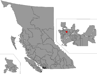
Richmond East was a provincial electoral district for the Legislative Assembly of British Columbia, Canada. It was replaced by the Richmond-Queensborough electoral district after the British Columbia electoral redistribution, 2015.

Vancouver-Kensington is a provincial electoral district for the Legislative Assembly of British Columbia, Canada.

Vancouver-Kingsway is a provincial electoral district for the Legislative Assembly of British Columbia, Canada.

West Vancouver-Capilano is a provincial electoral district for the Legislative Assembly of British Columbia, Canada.

Alice Lake Provincial Park is a provincial park in British Columbia, Canada.
Brackendale Eagles Provincial Park is a provincial park in British Columbia, Canada, located on the Squamish River adjacent to Brackendale, a suburban neighbourhood of Squamish.
Halkett Bay Provincial Park is a provincial park off Gambier Island in British Columbia, Canada.
Mount Elphinstone Provincial Park is a provincial park in British Columbia, Canada. Located near Mount Elphinstone, the park is on the west side of Howe Sound and north of the town of Gibsons and near the community of Roberts Creek. Created in 2000, the park is approximately 141 hectares in size.
Mount Richardson Provincial Park is a provincial park in British Columbia, Canada, located on the lower Sunshine Coast to the north of Sechelt.

Porpoise Bay Provincial Park is a provincial park in British Columbia, Canada.
Roberts Creek Provincial Park is a provincial park in British Columbia, Canada, located northwest of the community of Roberts Creek, between Gibsons and Sechelt. First created in 1947 with an area of 100 acres (0.40 km2), it was modified in size in 2000 to approximately 40 ha.
Sargeant Bay Provincial Park, is a provincial park in British Columbia, Canada, located just west of the community of Sechelt on the southern Sunshine Coast. Created in 1990 at 57 ha. in size, the park was expanded to approximately 142 ha. in 1997.

Simson Provincial Park is a provincial park in British Columbia, Canada.

Skookumchuck Narrows Provincial Park is a provincial park in British Columbia, Canada, protecting the saltwater rapids at the mouth of Sechelt Inlet known as the Sechelt Rapids, their location being known as Skookumchuck Narrows.
Spipiyus Provincial Park is a 2,979 hectare provincial park in British Columbia, Canada. Also known as the Caren Range, Spipiyus Park is north of Halfmoon Bay on the Sechelt Peninsula. It protects pockets of old-growth forest, prime habitat for the marbled murrelet. There are hiking trails that lead to Mount Hallowell with views of the islands and fjords of Pender Harbour, the Strait of Georgia and Vancouver Island.
Tantalus Provincial Park is a provincial park in British Columbia, Canada, comprising most of the Tantalus Range, just west of the town of Squamish.
Tetrahedron Provincial Park is a provincial park in British Columbia, Canada, located northeast of Sechelt in the Sunshine Coast area of the province. The park was created in 1995. Its highest point is Tetrahedron Peak, at 1727 meters. It also contains Panther Peak, and Mt. Steele
Diamond Glacier is a glacier in the Garibaldi Ranges of the Pacific Ranges in southwestern British Columbia, Canada. It lies on the Mount Garibaldi massif between Atwell Peak and Diamond Head.
Bridge River Delta Provincial Park is a provincial park in British Columbia, Canada, located 65 kilometres north of Pemberton, British Columbia, or 80 km west of Lillooet, British Columbia. The park, which is 992 ha. in size, was established in 2010.

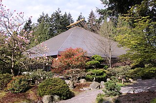
The Asian Centre is an academic library located on the Vancouver campus of the University of British Columbia, which primarily houses the collections of the University of British Columbia pertaining to Asian studies and Asia. The architecture of the Asian Centre is based on a traditional pagoda, and the building was designed by Donald Matsuba at the cost of $1.6 million Canadian dollars. The building was intended to be a centennial gift funded by the Government of Japan, serving as a symbol of Asian-Canadian and Canada–Japan relations.


