Related Research Articles
The Bay of Biscay, known in Spain as the Gulf of Biscay, and in France and some border regions as the Gulf of Gascony, is a gulf of the northeast Atlantic Ocean located south of the Celtic Sea. It lies along the western coast of France from Point Penmarc'h to the Spanish border, and along the northern coast of Spain, extending westward to Cape Ortegal. The southern area of the Bay of Biscay that washes over the northern coast of Spain is known locally as the Cantabrian Sea.

The Celtic Sea is the area of the Atlantic Ocean off the southern coast of Ireland bounded to the east by Saint George's Channel; other limits include the Bristol Channel, the English Channel, and the Bay of Biscay, as well as adjacent portions of Wales, Cornwall, and Brittany. The southern and western boundaries are delimited by the continental shelf, which drops away sharply. The Isles of Scilly are an archipelago of small islands in the sea.
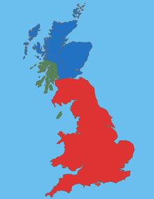
The Britons, also known as Celtic Britons or Ancient Britons, were the indigenous Celtic people who inhabited Great Britain from at least the British Iron Age until the High Middle Ages, at which point they diverged into the Welsh, Cornish and Bretons. They spoke Common Brittonic, the ancestor of the modern Brittonic languages.

England comprises most of the central and southern two-thirds of the island of Great Britain, in addition to a number of small islands of which the largest is the Isle of Wight. England is bordered to the north by Scotland and to the west by Wales. It is closer to continental Europe than any other part of mainland Britain, divided from France only by a 33 km (21 mi) sea gap, the English Channel. The 50 km (31 mi) Channel Tunnel, near Folkestone, directly links England to mainland Europe. The English/French border is halfway along the tunnel.

The English Lowlands beech forests is a terrestrial ecoregion in the United Kingdom, as defined by the World Wide Fund for Nature (WWF) and the European Environment Agency (EEA). It covers 45,600 km2 (17,600 sq mi) of Southern England, approximately as far as the border with Devon and South Wales in the west, into the Severn valley in the north-west, into the East Midlands in the north, and up to the border of Norfolk in the north-east. The WWF code for this ecoregion is PA0421.

The Tropical Atlantic realm is one of twelve marine realms that cover the world's coastal seas and continental shelves.

Great Britain is an island in the North Atlantic Ocean off the north-west coast of continental Europe, consisting of England, Scotland and Wales. With an area of 209,331 km2 (80,823 sq mi), it is the largest of the British Isles, the largest European island and the ninth-largest island in the world. It is dominated by a maritime climate with narrow temperature differences between seasons. The island of Ireland, with an area 40 per cent that of Great Britain, is to the west—these islands, along with over 1,000 smaller surrounding islands and named substantial rocks, form the British Isles archipelago.

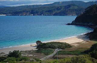
Iroise or the Iroise Sea is the part of the Atlantic Ocean which stretches from the Ile de Sein to Ushant off the coast of Brittany in north-western France. It is contained within the Celtic Sea, bordering the remainder of the Celtic Sea to the north and west, and the Bay of Biscay to the south. It is one of the most dangerous seas in Europe for sea-going vessels. In winter, there are often violent storms with huge waves. It is also one of the richest areas for marine life and was designated as one of UNESCO's biosphere reserves in 1988 and as France's first marine park in October 2007.
The following outline is provided as an overview of and introduction to Oceanography.
The Western Indo-Pacific is a biogeographic region of the Earth's seas, comprising the tropical waters of the eastern and central Indian Ocean. It is part of the larger Indo-Pacific, which includes the tropical Indian Ocean, the western and central Pacific Ocean, and the seas connecting the two in the general area of Indonesia. The Western Indo-Pacific may be classified as a marine realm, one of the great biogeographic divisions of the world's ocean basins, or as a subrealm of the Indo-Pacific.

The Central Indo-Pacific is a biogeographic region of Earth's seas, comprising the tropical waters of the western Pacific Ocean, the eastern Indian Ocean, and the connecting seas.
The Temperate Northern Pacific is a biogeographic region of the Earth's seas, comprising the temperate waters of the northern Pacific Ocean.

The Celtic broadleaf forests are a terrestrial ecoregion that covers most of the islands of Great Britain and Ireland.
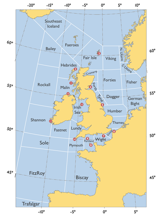
The Malin Sea is a marginal sea of the North-East Atlantic over the Malin Shelf, the continental shelf north of Ireland and southwest of Scotland. It is connected to the Irish Sea by the North Channel, and overlaps the Inner Seas off the West Coast of Scotland. Of the UK Shipping Forecast areas, the Malin Sea covers most of Malin, and by some definitions extends into Rockall. The area is within the exclusive economic zones of Ireland and the United Kingdom.

The marine ecoregions of the South African exclusive economic zone are a set of geographically delineated regions of similar ecological characteristics on a fairly broad scale, covering the exclusive economic zone along the South African coast.

Temperate Southern Africa is a biogeographic region of the Earth's seas, comprising the temperate waters of southern Africa, where the Atlantic Ocean and Indian Ocean meet. It includes the coast of South Africa and Namibia, and reaches into southern Angola. It also includes the remote islands of Amsterdam and Saint-Paul, to the east in the southern Indian Ocean.
Temperate South America is a biogeographic region of the Earth's seas, comprising the temperate and subtropical waters of South America, including both the Pacific and Atlantic coasts of the continent and adjacent islands. It also includes the remote Gough Island and Tristan da Cunha in the South Atlantic Ocean.

The Temperate Northern Atlantic is a biogeographic region of the Earth's seas, comprising the temperate and subtropical waters of the North Atlantic Ocean and connecting seas, including the Mediterranean Sea, Black Sea, and northern Gulf of Mexico.
References
- ↑ Spalding, Mark D., Helen E. Fox, Gerald R. Allen, Nick Davidson et al. "Marine Ecoregions of the World: A Bioregionalization of Coastal and Shelf Areas". Bioscience Vol. 57 No. 7, July/August 2007, pp. 573–583.
- ↑ "Celtic Seas ecoregion - ecosystem review". International Council for the Exploration of the Sea (ICES), 12 December 2019. Accessed 6 May 2020.