
Burlington is the most populous city in the U.S. state of Vermont and the seat of Chittenden County. It is located 45 miles (72 km) south of the Canada–United States border and 95 miles (153 km) south of Montreal. As of the 2020 U.S. census, the population was 44,743. It is the least populous city in the 50 U.S. states to be the most populous city in its state.

Essex Junction is a city in Chittenden County, Vermont, United States. As of the 2020 U.S. census, the population was 10,590. It was incorporated as a village on November 15, 1892. Essex Junction became Vermont’s 10th city on July 1, 2022.

Stowe is a town in Lamoille County, Vermont, United States. The population was 5,223 at the 2020 census. The town lies on Vermont Routes 108 and 100. It is nicknamed "The Ski Capital of the East" and is home to Stowe Mountain Resort, a ski facility with terrain on Mount Mansfield, the highest peak in Vermont, and Spruce Peak.

The University of Vermont (UVM), officially titled as University of Vermont and State Agricultural College, is a public land-grant research university in Burlington, Vermont. Founded in 1791, the university is the oldest in Vermont and the fifth-oldest in New England, making it among the oldest in the United States. It is one of the original eight Public Ivies.

The Taconic Mountains are a 150-mile-long sub-range of the Appalachian Mountains lying on the eastern border of New York State and adjacent New England. The range, which played a role in the history of geological science, is separated from the Berkshires and Green Mountains to the east by a series of valleys, principally those of the Housatonic River, Battenkill River and Otter Creek. The Taconics' highest point is Mount Equinox in Vermont at 3,840 feet (1,170 m); among many other summits are Dorset Mountain, Mount Greylock and Mount Everett.

Camel's Hump is a mountain in the Green Mountains in the U.S. state of Vermont. The north slope of the mountain borders the Winooski River, which has carved through the Green Mountains over eons. At 4,083 ft (1,244 m), it is tied with Mount Ellen for the third-highest mountain in Vermont. Surmounted by 10 acres (4 ha) of alpine tundra, the mountain is the most significant feature in Camel's Hump State Park. Because of its distinctive profile, it is perhaps the state's most recognized mountain, featured on the state quarter.

Centennial Field is the name of the baseball stadium at the University of Vermont in Burlington, Vermont, and is the home of the Vermont Lake Monsters.

The Cornell Botanic Gardens is a botanical garden located adjacent to the Cornell University campus in Ithaca, New York. The Botanic Gardens proper consist of 25 acres (10 ha) of botanical gardens and 150 acres (61 ha) of the F. R. Newman Arboretum. The greater Botanic Gardens includes 40 different nature areas around Cornell and Ithaca, covering 4,300 acres (1,700 ha).

The University of Guelph Arboretum is an arboretum organized by the University of Guelph in Guelph, Ontario. It was formally established in 1970 by the university and aims to conserve biodiversity and connect people with nature through teaching, research, and community outreach. The space is 165 hectares and is open throughout the year.
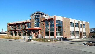
The Rubenstein School of Environment and Natural Resources (RSENR) is the University of Vermont's natural resources college. The University of Vermont recognized the importance of providing educational opportunities in this field of study, initiating forestry courses in 1888. The first school, originally called The School of Natural Resources was established in 1973. The main home of the Rubenstein School of Environment and Natural Resources, the George D. Aiken Center opened in 1982. The building's name honors Vermont's distinguished late senator and governor.

The John Heinz National Wildlife Refuge at Tinicum is a 1000-acre (4.05 km2) National Wildlife Refuge in Philadelphia and Tinicum Township, Pennsylvania. Adjacent to Philadelphia International Airport, the refuge protects the largest remaining freshwater tidal marsh in Pennsylvania. Established in 1972 as the Tinicum National Environmental Center, it was renamed in 1991 after the late H. John Heinz III, who helped preserve Tinicum Marsh.
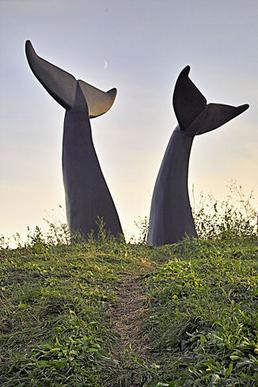
Reverence is a sculpture in Vermont created by Jim Sardonis in 1989 that depicts two tails of whales "diving" into a sea of grass. It is meant to symbolize the fragility of the planet. The tails were made from 36 tons of African black granite and stand 12 to 13 feet tall.
The Robert Larner College of Medicine is the medical school of the University of Vermont, a public research university in Burlington, Vermont. Established in 1822, it is the nation's seventh oldest medical school. The primary teaching hospital for the Larner College of Medicine is the UVM Medical Center in Burlington.

Fiddler's Elbow National Nature Reserve is a steep sided, woodland national nature reserve of 45 hectares in the Upper Wye Valley to the north of Monmouth in Wales, close to the Wales–England border. It is designated as a Site of Special Scientific Interest (SSSI) for its biological characteristics, containing a wide variety of flora.

The Vermont Catamounts are the varsity intercollegiate athletic programs of the University of Vermont, based in Burlington, Vermont, United States. The school sponsors 18 athletic programs, most of which compete in the NCAA Division I America East Conference (AEC), of which the school has been a member since 1979. The men's and women's ice hockey programs compete in Hockey East. The men's and women's alpine and nordic skiing teams compete in the Eastern Intercollegiate Ski Association (EISA). The school's athletic director is Jeff Schulman.

In 2018, Nigeria's primary energy consumption was about 155 Mtoe. Most of the energy comes from traditional biomass and waste, which accounted for 73.5% of total primary consumption in 2018. The rest is from fossil fuels (26.4%) and hydropower.
The William H. Miner Agricultural Research Institute is a private, not-for-profit educational research institution with an operational dairy farm and Morgan horse herd located in Chazy, New York on the Adirondack Coast of Lake Champlain. Miner Institute currently encompasses over 8,600 acres of forest and agricultural land in the Little Chazy and Great Chazy river watersheds. The Institute is funded through an endowment, research grants and the sale of milk from its dairy operation.
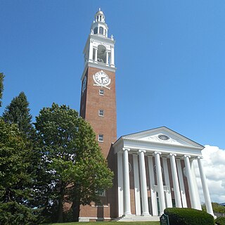
Ira Allen Chapel is a building on the campus of the University of Vermont (UVM), which is located on the northeast corner of the "University Green" in Burlington, Vermont. The building was constructed during 1925–26, and dedicated on January 14, 1927. It was added to National Register of Historic Places as part of University Green Historic District on April 14, 1975.
The desert-covered Kingdom of Saudi Arabia is the geographically largest country in the Middle East. Moreover, it accounts for 65% of the overall population of the GCC countries and 42% of its GDP. Saudi Arabia does not have a strong history in environmentalism. Thus, as the number of population increases and the industrial activity grows, environmental issues pose a real challenge to the country.

