Related Research Articles
The National Weather Service (NWS) is an agency of the United States federal government that is tasked with providing weather forecasts, warnings of hazardous weather, and other weather-related products to organizations and the public for the purposes of protection, safety, and general information. It is a part of the National Oceanic and Atmospheric Administration (NOAA) branch of the Department of Commerce, and is headquartered in Silver Spring, Maryland, within the Washington metropolitan area. The agency was known as the United States Weather Bureau from 1890 until it adopted its current name in 1970.

In air traffic control, an area control center (ACC), also known as a center or en-route center, is a facility responsible for controlling aircraft flying in the airspace of a given flight information region (FIR) at high altitudes between airport approaches and departures. In the US, such a center is referred to as an air route traffic control center (ARTCC).
SIGMET, or Significant Meteorological Information, is a severe weather advisory that contains meteorological information concerning the safety of all aircraft. Compared to AIRMETs, SIGMETs cover more severe weather. Today, according to the advancement of technology in civil aviation, the SIGMET is sent as IWXXM model.
An AIRMET, or Airmen's Meteorological Information, is a concise description of weather phenomena that are occurring or may occur (forecast) along an air route that may affect aircraft safety. Compared to SIGMETs, AIRMETs cover less severe weather: moderate turbulence and icing, sustained surface winds of 30 knots or more, or widespread restricted visibility. Today, according to the advancement of technology in civil aviation, the AIRMET is sent as IWXXM model.
Cleveland Air Route Traffic Control Center (ZOB) or Cleveland Center is located at 326 East Lorain Street, Oberlin, Ohio, United States. The center is located about 30 miles (48 km) outside of the city of Cleveland. The Cleveland ARTCC is the 3rd busiest of the 22 Air Route Traffic Control Centers in the United States. It oversees the airspace over portions of Maryland, Michigan, New York, Ohio, Pennsylvania, West Virginia, as well as the southernmost portion of Ontario, Canada.

Houston Air Route Traffic Control Center (ZHU) is located at George Bush Intercontinental Airport at 16600 JFK Boulevard, Houston, Texas, United States 77032. The Houston ARTCC is one of 22 Air Route Traffic Control Centers in the United States. Houston Center is the 9th busiest ARTCC in the United States.

The Los Angeles Air Route Traffic Control Center is an air traffic control center located in Palmdale, California, United States. Located adjacent to United States Air Force Plant 42 and the Palmdale Regional Airport, it is one of 22 Air Route Traffic Control Centers (ARTCC) operated by the United States Federal Aviation Administration (FAA).
Chicago Air Route Traffic Control Center (ZAU) is one of 22 Air Route Traffic Control Centers (ARTCCs) operated by the United States Federal Aviation Administration. It is located at 619 W. New Indian Trail Rd., Aurora, Illinois.

The Air Traffic Organization (ATO) is an air navigation service provider in the United States of America. The ATO is the operational division of the Federal Aviation Administration (FAA).

Anchorage Air Route Traffic Control Center (PAZA/ZAN) is an Area Control Center operated by the Federal Aviation Administration and is located just outside the main gate of Joint Base Elmendorf-Richardson at 700 North Boniface Parkway in Anchorage, Alaska, United States. The Anchorage ARTCC is one of 22 Air Route Traffic Control Centers in the United States.
Indianapolis Air Route Traffic Control Center (ZID), is one of 22 established FAA Area Control Centers, and is physically located at 1850 South Sigsbee Street, Indianapolis, Indiana,.
Jacksonville Air Route Traffic Control Center (ZJX), (radio communications, Jacksonville Center) is one of 22 Area Control Centers in the United States. It is located at 37075 Aviation Ln, Hilliard, Florida.
Kansas City Air Route Traffic Control Center, is one of 22 Federal Aviation Administration (FAA) Area Control Centers. It is located at 250 S. Rogers Rd. Olathe, Kansas, United States.
Salt Lake City Air Route Traffic Control Center (ZLC) is one of 22 FAA Area Control Centers in the United States. It is located in Salt Lake City, Utah, adjacent to Salt Lake City International Airport. It was opened in 1939 and was originally located on the third floor of the old Salt Lake City International Airport terminal. The Salt Lake Center (ZLC) covers one of the largest geographical areas of any control center, totaling approximately 350,000 squares miles.
Miami Air Route Traffic Control Center is one of 22 United States air route traffic control centers (ARTCs), or area control centers, located at 7500 N.W. 58th st, Miami-Dade County, Florida.
Memphis Air Route Traffic Control Center (ZME) (radio communications, "Memphis Center") is one of 22 United States Federal Aviation Administration (FAA) Area Control Centers and is located at 3229 Democrat Rd, Memphis, Tennessee 38118, United States
Minneapolis Air Route Traffic Control Center (ZMP), (radio communications, "Minneapolis Center") is one of 22 Area Control Centers. It is located at 512 Division Street in Farmington, Minnesota, United States.

Oakland Air Route Traffic Control Center (ZOA), (radio communications, "Oakland Center") is one of 22 Area Control Centers in the United States. It is located at 5125 Central Ave, Fremont, California, roughly 25 miles southeast of downtown Oakland in the East Bay.
Atlanta Air Route Traffic Control Center (ZTL) (radio communications, "Atlanta Center") is one of 22 Air Route Traffic Control Centers operated by the United States Federal Aviation Administration. It is located at 299 Woolsey Rd, Hampton, Georgia, United States.
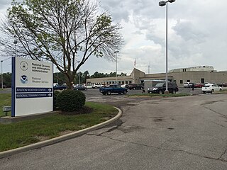
The Aviation Weather Center (AWC) provides weather information and forecasts for air flights over United States territory and at certain altitudes for global traffic. It works with customers, such as commercial airlines, and international partners to improve flight safety and efficiency. It is one of the components of the National Centers for Environmental Prediction of the National Weather Service (NWS) of the United States.
References
- ↑ "Archived copy" (PDF). Archived from the original (PDF) on 2008-06-25. Retrieved 2008-03-29.
{{cite web}}: CS1 maint: archived copy as title (link)