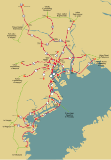
Central Circular Route (Shuto Expressway)

Last updated

Shuto Urban Expwy Sign C2.svg
Kasai JCT Shuto expressway kasai jct.jpg
Kasai JCT
Ogi-ohashi exit Shuto expressway ogiohashi.jpg
Ōgi-ōhashi exit
Senju-shinbashi exit Shuto expressway senjushinbashi.jpg
Senju-shinbashi exit
Kohoku JCT Shuto expressway kohoku jct.jpg
Kohoku JCT

The Central Circular Route(中央環状線,Chūō Kanjō-sen), signed as Route C2, is one of the routes of the Shuto Expressway system serving the central part of the Greater Tokyo Area. The route is a circumferential highway running through the outer wards of Tokyo. The route is the middle of three ring expressways planned for the city; the other two being the C1 Inner Circular Route and the C3 Tokyo Gaikan Expressway.

Shuto Expressway Highway network in the metropolis of Tokyo in Japan.

Shuto Expressway is a network of toll expressways in the Greater Tokyo Area of Japan. It is operated and maintained by the Metropolitan Expressway Co., Ltd..

Greater Tokyo Area Place in Japan ----

The Greater Tokyo Area is the most populous metropolitan area in the world, consisting of the Kantō region of Japan, including Tokyo Metropolis, as well as the prefecture of Yamanashi of the neighboring Chūbu region. In Japanese, it is referred to by various terms, one of the most common being Capital Region.

Tokyo Gaikan Expressway Highway in Tokyo and Chiba prefecture, Japan (C3).

The Tokyo Gaikan Expressway is a national expressway in Japan. It is owned and operated by East Nippon Expressway Company.

The complete route is 48.8 km in length. Construction work on underground sections of the route began in 1992 with the final section opened to traffic on 7 March, 2015. Given the extensive tunneling and engineering challenges involved construction costs for the route were estimated to be 2 Trillion yen. [1]

The route is approximately 8km from the center of the city and goes through the wards of Edogawa, Katsushika, Adachi, Kita, Itabashi, Toshima, Shinjuku, Nakano, Shibuya, Meguro, and Shinagawa.

Edogawa, Tokyo Special ward in Kantō, Japan

Edogawa is a special ward located in Tokyo Metropolis, Japan. It takes its name from the Edo River that runs from north to south along the eastern edge of the ward. In English, it uses the name Edogawa City.

Adachi, Tokyo Special ward in Kantō, Japan

Adachi is a special ward located in Tokyo Metropolis, Japan. It is located north of the heart of Tokyo. The ward consists of two separate areas: a small strip of land between the Sumida River and Arakawa River and a larger area north of the Arakawa River. The ward is bordered by the cities of Kawaguchi, Sōka and Yashio in Saitama and Katsushika, Sumida, Arakawa, and Kita in Tokyo. The ward is called Adachi City in English.

Kita, Tokyo Special ward in Kantō, Japan

Kita is a special ward located in Tokyo Metropolis, Japan. The English translation of its Japanese self-designation is City of Kita. The ward was founded on March 15, 1947.

Yamate Tunnel Shutoko-YamateTunnel.JPG
Yamate Tunnel

The Yamate Tunnel forms a key part of the Central Circular Route. A deep underground tunnel constructed beneath Yamate Dori, the first section over 11km in length, was opened to traffic on December 22, 2007. From 2010 the tunnel extended the Central Circular Route south from near Ikebukuro to Ohashi Junction connecting with Route 3. The last 9.4 km through Meguro and Shinagawa was opened to traffic on March 7, 2015. [2] When this last section of the tunnel opened the Yamate Tunnel formed Japan's longest, and the world's second longest road tunnel. [3] During the tunnel's first week of operations, traffic volume on the Inner Circular Route was reduced by seven percent from the previous week, and congestion on expressways inside the Central Circular Route (an index measured by recording segments where average traffic speed is less than 40 km/h, and multiplying the affected distance by the affected time) was approximately halved from the previous week. [4]

Yamate Tunnel

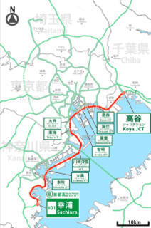
The Yamate Tunnel carries the Central Circular Route (C2) of the Shuto Expressway in Tokyo, Japan from the Takamatsu on-ramp in Toshima to near the Ōi Junction in Shinagawa. The overall length is 18.2 km.

Ikebukuro town located in Toshima-ku, Tokyo

Ikebukuro is a commercial and entertainment district in Toshima, Tokyo, Japan. Toshima ward offices, Ikebukuro station, and several shops, restaurants, and enormous department stores are located within city limits.

Route 3 (Shuto Expressway) radial route of the Shuto Expressway

Route 3 is one of the radial routes of the Shuto Expressway system in the Tokyo area. Route 3 runs southwest from Tanimachi Junction in Minato-ku and runs for 12 kilometres through Shibuya-ku, Meguro-ku, and Setagaya-ku. The Route 3 designation ends at the Yoga Rampway and the expressway continues as the intercity Tomei Expressway to Nagoya.

The C2 begins and ends at the Bayshore Route, which serves to close the loop.

Bayshore Route Japanese highway between Kanagawa, Tokyo and Chiba prefecture, Japan

The Bayshore Route of Shuto Expressway is a stretch of toll highway in Greater Tokyo, 70 km, that runs from Yokohama city, Kanazawa ward, to Ichikawa city of Chiba Prefecture. It is an important route that runs between artificial islands of Tokyo Bay by way of bridges and sub-sea tunnels, bypassing Tokyo entirely.

Exit List

List of currently existing interchanges and exits ordered following the outer loop (clockwise):

MunicipalityExit/interchange nameDestinationsNotes
Shinagawa-kuŌi JCT Bayshore Route
Meguro-kuŌhashi JCT Route 3 (Shuto Expressway) Outbound to Yōga and Tōmei Expressway. Inbound to Tanimachi from Inner Loop.
Shibuya-kuTomigaya
C22
Shibuya-kuHatsudai-Minami
C23
Shinjuku-kuNishi-shinjuku JCT Route 4 Outbound to Takaido and Chūō Expressway. Inbound to Miyakezaka from Inner Loop.
Nakano-kuNakano-chojabashi
C24
Shinjuku Station, Tokyo Metropolitan Government OfficeInner loop exit/outer loop entrance only
Shinjuku-kuNaka-ochiai JCT (Planned)Planned Nerima Route outbound to Nerima and Kan-etsu Expressway.Tokyo Metropolitan Expressway Corporation plans to connect between C2 and Kan-estu Expressway through Nerima Route.
Toshima-kuNishi-ikebukuro Entrance
C25
Ikebukuro Station Inner loop entrance/outer loop exit only
Toshima-kuNishi-ikebukuro Exit
C26
Ikebukuro StationInner loop exit.
Itabashi-kuTakamatsu Entrance
C28
Yamate-dori streetOuter loop entrance only. Inner loop exit has closed and moved to Nishi-ikebukuro in 2007, due to the extension of Yamate Tunnel.
Itabashi-kuKumanocho JCT Route 5 inbound to Higashi-ikebukuro and Takebashi JCT from Inner loop.

Route C2 Outer Loop to Route 5 inbound is not connected.

inbound only
Itabashi-kuItabashi JCT Route 5 outbound to Ōmiya and Kan-etsu Expressway via Tokyo Gaikan Expressway.outbound only
Itabashi-kuShin-itabashi
C29
National Route 17, also known as Nakasendō avenueOuter loop exit only
Itabashi-kuTakinogawa
C31
National Route 17, also known as Nakasendō avenueInner loop entrance only
Kita-kuŌji-minami
C33
Ōji Station, Asukayama Park.Under construction: Inner loop entrance/outer loop exit.
This interchange is currently being reconstructed into a full interchange in combination with Oji-kita Rampway.
Kita-kuŌji-kita
C34
Ōji Station, Asukayama Park.Inner loop exit/outer loop entrance
Note: this interchange is currently being reconstructed into a full interchange in combination with Oji-minami Rampway.
Adachi-kuKōhoku JCT Route S1 to Angyō and Tōhoku Expressway
Adachi-kuOgiohashi
C35, C36
Adachi-kuSenju-shimbashi
C37, C38
Kita-senju Station, National Route 4, also known as Nikkō Kaidō avenue
Katsushika-kuKosuge JCT Route 6 outbound to Misato and Jōban Expressway
Katshushika-kuKosuge
C40
Inner loop exit/outer loop entrance
Katsushika-kuHorikiri JCT Route 6 inbound to Ginza and Hakozaki
Katsushika-kuYotsugi
C41, C42
National Route 6, also known as Mito Kaidō avenue
Katsushika-kuHirai-ōhashi
C43
Outer loop exit/inner loop entrance
Edogawa-kuKomatsugawa JCT (Planned)Crosses over Route 7 without connection.
Tokyo Metropolitan Expressway Corporation plans to connect between C2 inner loop and route 7 inbound.
Edogawa-kuFunaboribashi
C44
Inner loop exit/outer loop entrance
Edogawa-kuSeishinchō
C45
Outer loop exit/inner loop entrance
This freeway stub will become part of Route 10
Edogawa-kuKasai JCT Bayshore Route East to Urayasu and Higashi-Kantō Expressway
Bayshore Route West to Shin-kiba and Haneda Airport

Related Research Articles

Osaka Loop Line railway line in Osaka, Osaka prefecture, Japan

The Osaka Loop Line is a railway loop line in Japan operated by the West Japan Railway Company. It encircles central Osaka.

Meguro Special ward in Kantō, Japan

Meguro is a special ward in Tokyo, Japan. The English translation of its Japanese self-designation is Meguro City. The ward was founded on March 15, 1947.

Yamanote Line railway loop line in Japan serving between Shinagawa, Shibuya, Shinjuku, Ikebukuro, Ueno, and Tokyo stations

The Yamanote Line is a railway loop line in Tokyo, Japan, operated by East Japan Railway Company. It is one of Tokyo's busiest and most important lines, connecting most of Tokyo's major stations and urban centres, including Marunouchi, the Yūrakuchō/Ginza area, Shinagawa, Shibuya, Shinjuku, Ikebukuro and Ueno, with all but two of its 29 stations connecting to other railway or underground (subway) lines.

Chūō Shinkansen Maglev high-speed train line under construction in Japan

The Chuo Shinkansen is a Japanese maglev line under construction between Tokyo and Nagoya, and planned to be extended to Osaka. Its initial section is between Shinagawa Station in Tokyo and Nagoya Station in Nagoya, with stations in Sagamihara, Kanagawa Prefecture, Kōfu, Yamanashi Prefecture, and Nakatsugawa, Gifu Prefecture, as well as an as yet undetermined location in Nagano Prefecture. The line is expected to connect Tokyo and Nagoya in 40 minutes, and eventually Tokyo and Osaka in 67 minutes, running at a maximum speed of 505 km/h (314 mph). About 90% of the 286-kilometre (178 mi) line to Nagoya will be built underground or through tunnels, with a minimum curve radius of 8,000 m (26,000 ft) and a maximum grade of 4%.

Yokosuka Line railway line

The Yokosuka Line is a railway line in Japan operated by the East Japan Railway Company.

Osaka Higashi Line railway line in Osaka prefecture, Japan

The Osaka Higashi Line is a railway line in Osaka, Japan, operated by the West Japan Railway Company (JR-West). Before being named on August 23, 2007, the line was constructed with the tentative name "Osaka Outer Loop Line". Conceived in the 1950s during Japan's explosive postwar economic growth, it was planned as a grand "outer loop" of the city, using existing freight lines to link Amagasaki with Shin-Osaka, Suita, Awaji, Hanaten, Kami, Uriwari and Sugimotochō, with a newly constructed segment into Osaka's Nankō Port Town. However, with JNR's financial situation deteriorating catastrophically and continuing issues surrounding land acquisition and squatting by local residents on railway property, the plan was cut back to Shin-Osaka and Kami, terminating at Kyūhōji in the south. The line connects Shin-Osaka Station in northern Osaka with Kyūhōji Station in Yao, forming an arc around the northern and eastern suburbs of the city.

Toei Ōedo Line metro line in Tokyo, Japan

The Toei Ōedo Line is a subway line in Tokyo, Japan, operated by the Tokyo Metropolitan Bureau of Transportation (Toei). It commenced full operations on December 12, 2000; using the Japanese calendar this reads "12/12/12" as the year 2000 equals Heisei 12. The line is completely underground, making it the second-longest railway tunnel in Japan after the Seikan Tunnel.

Chūō Expressway road in Japan

The Chūō Expressway is a national expressway in Japan. It is owned and operated by Central Nippon Expressway Company.

Tokyo Metro Namboku Line metro line in Tokyo, Japan

The Tokyo Metro Namboku Line is a subway line owned and operated by the Tokyo subway operator Tokyo Metro in Tokyo, Japan. Its name literally means "South-North Line". The line runs between Meguro in Shinagawa and Akabane-Iwabuchi in Kita. The Namboku Line was referred to as Line 7 during the planning stages, thus the seldom-used official name is Line 7 Namboku Line.

Provincial Highway 74 (Taiwan) road in Taiwan

Provincial Highway 74, also known as the Kuaiguan-Wufeng Expressway (快官烏日線) or Taichung Ring Expressway (台中環線), is an expressway around Taichung City. It starts at Kuaiguan Interchange on Freeway No. 3 in Changhua City and ends at Wufeng Interchange on Freeway No. 3 in Wufeng District.

Ken-Ō Expressway It is external road ring C4, around Tokyo (Expressway in Japan).

The Ken-O Expressway, or Metropolitan Inter-City Expressway, is a partially completed ticket system toll expressway in Japan. It is owned and operated by the Central Nippon Expressway Company and East Nippon Expressway Company. In conjunction with the Tokyo Bay Aqua-Line and the Bayshore Route of the Shuto Expressway, the expressway will form a full outer ring road of Tokyo. It is signed as National Route 468 as well as C4 under the "2016 Proposal for Realization of Expressway Numbering."

Inner Circular Route (Shuto Expressway) Inner Circular Route in Tokyo (Shuto Expressway).

The Inner Circular Route, signed as Route C1, is one of the routes of the Shuto Expressway system serving the central part of the Greater Tokyo Area. The route is a complete loop around the central Tokyo wards of Chiyoda, Chūō, and Minato, with a total length of 14.3 km (8.9 mi). In addition to serving areas of central Tokyo, the Inner Circular Route is also serves the origin of the Shuto Expressway radial routes. Part of the expressway is built above the Shibuya River.

Aichi Loop Line railway line in Aichi prefecture, Japan

The Aichi Loop Line is a Japanese railway line connecting Okazaki Station in Okazaki and Kōzōji Station in Kasugai, operated by the Aichi Loop Railway. The company or the line is abbreviated as Aikan (愛環). This is the only line the company operates. Despite its name, the line is not a true loop, but a north-south line situated east of Nagoya, which can be considered as an unclosed loop.

Tōkai-Kanjō Expressway road in Aichi Prefecture, Gifu Prefecture and Mie Prefecture in Japan

The Tōkai-Kanjō Expressway is a toll road in the Tōkai region of Japan. It is owned and managed by Central Nippon Expressway Company.

The Nagoya Expressway Ring Route is an urban expressway in Nagoya, Japan. It is a part of the Nagoya Expressway network and is owned and operated by Nagoya Expressway Public Corporation.

Meguro Sky Garden park in Meguro, Tokyo

Meguro Sky Garden is a linear roof garden park in Ohashi, Meguro, Tokyo, Japan, constructed on a sloping roof rising from 15 to 35 meters above street level. The garden serves to cover the intersection of two major expressways; the elevated Route 3 Shibuya radial route and the deep level subterranean Central Circular Route C2.

References

  1. "Tokyo's 47-km-long expressway loop fully opens". The Japan Times. Jiji. 7 March 2015. Retrieved 7 March 2015.
  2. "Completion Date of Central Circular Route". Press Release. Metropolitan Expressway Co. Ltd. 16 April 2013. Retrieved 7 April 2014.
  3. "Planning and Construction - Urban Long Tunnels, Yamate Tunnel". Shutoko. Metropolitan Expressway Company Limited. Retrieved 6 March 2015.
  4. 下田, 健太郎 (19 March 2015). "中央環状線内側の首都高各線で渋滞・混雑量が半減". Nihon Keizai Shimbun. 日経コンストラクション. Retrieved 20 March 2015.