Kan-Etsu Expressway

Last updated

Kan-etsu Expwy Route Sign.svg

Kan-Etsu Expressway
関越自動車道 E17 Expressway (Japan).png
Route information
Length245.8 km [1] (152.7 mi)
Existed1971 [2] –present
Major junctions
From Nerima Interchange in Nerima, Tokyo
Tokyo Metropolitan Route 24
ToNagaoka Junction in Nagaoka, Niigata
E8 Expressway.png Hokuriku Expressway
Location
Major cities Kawagoe, Fujioka, Takasaki, Maebashi, Ojiya
Highway system
National highways of Japan
Expressways of Japan

The Kan-Etsu Expressway(関越自動車道,Kan'etsu Jidōsha-dō) is a national expressway in Japan. It is owned and managed by East Nippon Expressway Company.

Expressways of Japan

The expressways of Japan make up a large network of controlled-access toll expressways.

East Nippon Expressway Company business

The East Nippon Expressway Company Limited, abbreviated as NEXCO East Japan, is one of the main operators of expressways and toll roads in Japan. It is headquartered in Kasumigaseki, Chiyoda, Tokyo.

Contents

Naming

Kan-Etsu(関越) is the kanji acronym of Kantō () and the old Echigo Province (後国) comprising modern-day Niigata Prefecture.

<i>Kanji</i> adopted logographic Chinese characters used in the modern Japanese writing system

Kanji are the adopted logographic Chinese characters that are used in the Japanese writing system. They are used alongside the Japanese syllabic scripts hiragana and katakana. The Japanese term kanji for the Chinese characters literally means "Han characters". It is written with the same characters in the Chinese language to refer to the character writing system, hanzi (漢字).

Kantō region Region

The Kantō region is a geographical area of Honshu, the largest island of Japan. The region includes the Greater Tokyo Area and encompasses seven prefectures: Gunma, Tochigi, Ibaraki, Saitama, Tokyo, Chiba, and Kanagawa. Within its boundaries, slightly more than 45 percent of the land area is the Kantō Plain. The rest consists of the hills and mountains that form the land borders. According to the official census on October 1, 2010 by the Japan Statistics Bureau, the population was 42,607,376, amounting to approximately one third of the total population of Japan.

Echigo Province province of Japan

Echigo Province was an old province in north-central Japan, on the shores of the Sea of Japan. It bordered on Uzen, Iwashiro, Kōzuke, Shinano, and Etchū Provinces. It corresponds today to Niigata Prefecture, minus the island of Sado.

Officially, the Kan-Etsu consists of two routes. Both begin in Tokyo and end in Niigata Prefecture. The Kan-Etsu Expressway Niigata Route consists of the entire Kan-Etsu Expressway from Nerima to Nagaoka, as well as the Hokuriku Expressway beyond Nagaoka to its terminus in the city of Niigata. The Kan-Etsu Expressway Jōetsu Route is concurrent with the Niigata Route until Fujioka Junction, where it branches off as the Jōshin-etsu Expressway and traverses Nagano Prefecture to its terminus in Jōetsu, Niigata. [3] The remainder of this article will focus on the Niigata Route section between Nerima and Nagaoka.

Tokyo Metropolis in Kantō

Tokyo, officially Tokyo Metropolis, one of the 47 prefectures of Japan, has served as the Japanese capital since 1869. As of 2018, the Greater Tokyo Area ranked as the most populous metropolitan area in the world. The urban area houses the seat of the Emperor of Japan, of the Japanese government and of the National Diet. Tokyo forms part of the Kantō region on the southeastern side of Japan's main island, Honshu, and includes the Izu Islands and Ogasawara Islands. Tokyo was formerly named Edo when Shōgun Tokugawa Ieyasu made the city his headquarters in 1603. It became the capital after Emperor Meiji moved his seat to the city from Kyoto in 1868; at that time Edo was renamed Tokyo. Tokyo Metropolis formed in 1943 from the merger of the former Tokyo Prefecture and the city of Tokyo. Tokyo is often referred to as a city but is officially known and governed as a "metropolitan prefecture", which differs from and combines elements of a city and a prefecture, a characteristic unique to Tokyo.

Hokuriku Expressway national expressway in Japan

The Hokuriku Expressway, (abbreviated as Hokuriku Expwy, is a 4-laned national expressway in Japan. It is owned and managed by East Nippon Expressway Company and Central Nippon Expressway Company.

Jōshin-etsu Expressway national expressway in Japan

The Jōshin-etsu Expressway is a national expressway in Japan. It is owned and operated by East Nippon Expressway Company.

Overview

Kan-Etsu Expressway in Minamiuonuma Kanetsujidoshado.jpg
Kan-Etsu Expressway in Minamiuonuma

The expressway begins in Nerima Ward in the north of Tokyo; the Kan-etsu is the only national expressway linking Tokyo that does not have a direct connection with the urban Shuto Expressway network. A junction with the Tokyo Gaikan Expressway near the origin links the Kan-etsu with other expressways serving northern parts of the Tokyo urban area. From here the expressway follows a roughly northwesterly course to its terminus in Niigata Prefecture, passing through central areas of Saitama Prefecture and Gunma Prefecture. In Gunma the Kan-etsu provides access to Nagano Prefecture by way of the Jōshin-etsu Expressway at Fujioka Junction, and completion of the Kita-Kantō Expressway in 2011 [4] will facilitate access to Tochigi Prefecture and Ibaraki Prefecture. The mountainous area separating Gunma and Niigata Prefectures is traversed by the Kan-Etsu Tunnel, the second longest road tunnel in Japan. [5] The expressway then passes through southern Niigata Prefecture before terminating at a junction with the Hokuriku Expressway in Nagaoka.

Shuto Expressway Highway network in the metropolis of Tokyo in Japan.

Shuto Expressway is a network of toll expressways in the Greater Tokyo Area of Japan. It is operated and maintained by the Metropolitan Expressway Co., Ltd..

Tokyo Gaikan Expressway Highway in Tokyo and Chiba prefecture, Japan (C3).

The Tokyo Gaikan Expressway is a national expressway in Japan. It is owned and operated by East Nippon Expressway Company.

Saitama Prefecture Prefecture of Japan

Saitama Prefecture is a prefecture of Japan located in the Kantō region. The capital is the city of Saitama.

The expressway parallels National Route 17 and the Jōetsu Shinkansen of East Japan Railway Company for most of its length.

Japan National Route 17 road in Japan

National Route 17 is a highway on the island of Honshu in Japan. It originates at Nihonbashi in Chūō, Tokyo, and terminates in the city of Niigata, where it meets Routes 7, 8, 49, 113 and 116).

Jōetsu Shinkansen high-speed railway line in Japan servicing between (through from Tokyo) Ōmiya and Niigata stations

The Jōetsu Shinkansen (上越新幹線) is a high-speed shinkansen railway line connecting Tokyo and Niigata, Japan, via the Tōhoku Shinkansen, operated by the East Japan Railway Company. Despite its name, the line does not pass through the city of Joetsu, which instead is served by the Hokuriku Shinkansen.

East Japan Railway Company Japanese railway company

East Japan Railway Company is a major passenger railway company in Japan and is the largest of the seven Japan Railways Group companies. The company name is officially abbreviated as JR-EAST or JR East in English, and as JR Higashi-Nihon in Japanese. The company's headquarters are in Yoyogi, Shibuya, Tokyo.

The first section opened in 1971 and the entire route was opened to traffic in 1985. [6] The route is six lanes from Ōizumi Junction to Shibukawa-Ikaho Interchange, and all other sections are four lanes.

Ōizumi Junction is a road interchange located in Nerima, Tokyo, Japan.

List of interchanges and features

No.NameConnectionsDist. from
origin
Dist. from
terminus
Bus stopNotesSpeed limitLocation
1 Nerima IC Met. Route 24 (Nerima Tokorozawa Route / Mejiro Dōri)0.0246.280 km/h Nerima Tokyo
2 Ōizumi JCT C3 Expressway (Japan).png Tokyo Gaikan Expressway 0.8245.0IC entrance: Nagaoka-bound only
Ōizumi ICMet. Route 24 (Nerima Tokorozawa Route / Mejiro Dōri)
TBNiiza Toll Gate Niiza Saitama
100 km/h
3Tokorozawa ICJapanese National Route Sign 0463.svg National Route 463 (Urawa Tokorozawa Bypass)9.4236.4 Tokorozawa
PAMiyoshi PA/
SIC
14.0231.8 Miyoshi
4Kawagoe ICJapanese National Route Sign 0016.svg National Route 16 21.2224.6 Kawagoe
BSKawagoe-
Matoba BS
4-1Tsurugashima JCT Japanese National Route Sign 0468.svg C4 Expressway (Japan).jpg Ken-Ō Expressway 28.1217.7 Tsurugashima
5Tsurugashima ICJapanese National Route Sign 0407.svg National Route 407 29.6216.2
5-1Sakado-Nishi SICPref. Route 39 (Kawagoe Sakado Moroyama Route)32.5213.3 Sakado
SATakasaka SA34.7211.1 Higashi-
matsuyama
6Higashi-
matsuyama IC
Japanese National Route Sign 0254.svg National Route 254
Pref. Route 47 (Fukaya Higashimatsuyama Route)
39.4206.4
6-1Ranzan-Ogawa ICPref. Route 11 (Kumagaya Ogawa Chichibu Route)47.4198.4 Ranzan
PARanzan PA50.1195.7
7Hanazono ICJapanese National Route Sign 0140.svg National Route 140 56.1189.7 Fukaya
PAYorii PA63.4182.4 Fukaya/
Yorii
8Honjō-Kodama ICJapanese National Route Sign 0462.svg National Route 462 69.6176.2 Honjō
8-1
SA
Kamisato SA/
SIC
75.5170.3 Kamisato
9Fujioka JCT E18 Expressway (Japan).png Jōshin-etsu Expressway 78.6167.2 Fujioka Gunma
9-1Takasaki-Tamamura SICJapanese National Route Sign 0354.svg National Route 354 (Takasaki-Tamamura Bypass)82.7163.1 Takasaki
9-2Takasaki JCTE50 Expressway (Japan).png Kita-Kantō Expressway 84.6161.2
10Takasaki ICPref. Route 27 (Takasaki Komagata Route)87.0158.8
11Maebashi ICJapanese National Route Sign 0017.svg National Route 17 92.1153.7 Takasaki/
Maebashi
11-1
PA
Komayose PA/
SIC
98.3147.5 Yoshioka
12Shibukawa-Ikaho ICJapanese National Route Sign 0017.svg National Route 17 (Shibukawa Bypass)103.2142.6 Shibukawa
80 km/h
BRNo.1 Tonegawa BridgeLength: 784 m
CBMiharada CBNerima-bound only
12-1/
PA
Akagi IC/PAPref. Route 70 (Ōmama Kamishiroi Route)111.0134.8
SAAkagi-kōgen SA118.3127.5 Shōwa
12-2Showa ICPref. Route 65 (Shōwa Inter Route)120.4125.4
13Numata ICJapanese National Route Sign 0120.svg National Route 120 125.6120.2 Numata
CBNumata CBNagaoka-bound only
14Tsukiyono ICJapanese National Route Sign 0017.svg National Route 17 130.9114.9 Minakami
PAShimomoku PA135.3110.5
BRŌmine BridgeLength: 784 m
15Minakami ICJapanese National Route Sign 0291.svg National Route 291 140.8105.0
PATanigawadake PA145.8100.0
TNKan-Etsu TunnelNerima-bound 11,055 m
Nagaoka-bound 10,926 m
70 km/h
Yuzawa Niigata
PATsuchitaru PA157.388.580 km/h
16Yuzawa ICJapanese National Route Sign 0017.svg National Route 17 166.779.1
TNIshiuchi TunnelNerima-bound 1,590 m
Nagaoka-bound 1,500 m
Minami-
uonuma
SAShiozawa-
Ishiuchi SA
(173.5)72.3Nerima-bound only
16-1/
SA
Shiozawa-
Ishiuchi IC/SA
Pref. Route 28 (Shiozawa Yamato Route)175.270.6SA: Nagaoka-bound only
BRNakanojima BridgeLength: 460 m
17Muikamachi ICJapanese National Route Sign 0253.svg National Route 253 186.659.2
BRHakkai BridgeLength: 610 m
17-1/
PA
Yamato PA/
SIC
198.047.8
18Koide ICJapanese National Route Sign 0291.svg National Route 291 204.141.7 Uonuma
18-1/
PA
Horinouchi IC/PAPref. Route 23 (Kashiwazaki Takahama Horinouchi Route)211.734.1
BRKawaguchi Bridge Nagaoka
19/SAEchigo-Kawaguchi IC/SAPref. Route 83 (Kawaguchi Shiodono Route)220.625.2
TNYamamotosan Tunnel Ojiya
20Ojiya ICJapanese National Route Sign 0291.svg National Route 291 228.517.3
100 km/h
PAYamaya PA230.615.2
BSKatakai BS234.711.1
BSKoshiji BS238.47.4 Nagaoka
20-1Nagaokaminami-
Koshiji SIC
Pref. Route 23 (Kashiwazaki Takahama Horinouchi Route)
21Nagaoka ICJapanese National Route Sign 0008.svg National Route 8 244.21.6
80 km/h
(37)Nagaoka JCTE8 Expressway.png Hokuriku Expressway 245.80.0
Through to E8 Expressway.png Hokuriku Expressway

Related Research Articles

Niigata Prefecture Prefecture of Japan

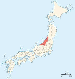
Niigata Prefecture is a prefecture of Japan located in the Chūbu region of Honshu. Niigata Prefecture has a population of 2,285,856 (2016) and is the fifth-largest prefecture of Japan by geographic area at 12,582 km2. Niigata Prefecture borders Toyama Prefecture and Nagano Prefecture to the southwest, Gunma Prefecture to the south, Fukushima Prefecture to the east, and Yamagata Prefecture to the northeast.

Gunma Prefecture Prefecture of Japan

Gunma Prefecture is a prefecture of Japan located in the Kantō region. Its capital is Maebashi.

Sanjō, Niigata City in Chūbu, Japan

Sanjō is a city located in Niigata Prefecture, Japan. As of 30 September 2018, the city had an estimated population of 98,401 in 36,201 households, and a population density of 228 persons per km². The total area of the city was 431.97 square kilometres (166.78 sq mi).

Hokuriku region

The Hokuriku region was located in the northwestern part of Honshu, the main island of Japan. It lay along the Sea of Japan within the Chūbu region, which it is currently a part of. It is almost equivalent to Koshi Province and Hokurikudō area in pre-modern Japan. Due to its elongated shape, and the Noto Peninsula jutting out, the region is known as a 'rising dragon' 昇龍道. Since the Heian period until the Edo period the region was a core recipient of population, the population grew to be much larger proportionately than it is today, despite the rural character. With the growth of urban centers in the 20th century, particularly Tokyo and Chūkyō, the Hokuriku has steadily declined in importance to become relative backwaters. The region is also known for traditional culture that originated from elsewhere that has been long lost along the Taiheiyō Belt.

Yuzawa, Niigata Town in Chūbu, Japan

Yuzawa is a town located in Niigata Prefecture, Japan. As of 1 April 2018, the town had an estimated population of 8,074, and a population density of 23 persons per km². The total area of the town was 257.29 square kilometres (99.34 sq mi). The town is famous for its hot springs.

2004 Chūetsu earthquake earthquake occurred in Niigata Prefecture, Japan on October 23, 2004

The Chūetsu earthquakes occurred in Niigata Prefecture, Japan, at 17:56 local time on Saturday, October 23, 2004. The Japan Meteorological Agency (JMA) named it the "Heisei 16 Niigata Prefecture Chuetsu Earthquake". Niigata Prefecture is located in the Hokuriku region of Honshu, the largest island of Japan. The initial earthquake had a magnitude of 6.6 and caused noticeable shaking across almost half of Honshu, including parts of the Tōhoku, Hokuriku, Chūbu, and Kantō regions.

Jōetsu Line railway line in Japan

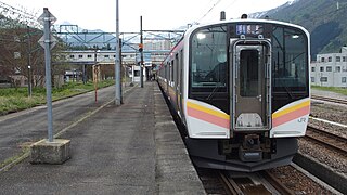
The Joetsu Line is a major railway line in Japan, owned by the East Japan Railway Company. It connects Takasaki Station in Gunma Prefecture with Miyauchi Station in Niigata Prefecture, linking the northwestern Kanto region and the Sea of Japan coast of the Chūbu region. The name refers to the old provinces of Kōzuke (野) and Echigo (後), which the line connects.

Jōshinetsu-kōgen National Park national park of Japan

Jōshin'etsu-kōgen National Park is a national park in the Chūbu region of the main island of Honshū, Japan formed around several active and dormant volcanoes. It spans the mountainous areas of Gunma, Nagano, and Niigata prefectures. The name refers to the two mountain ranges that make up the park. It was divided into two separate areas: the Southern Niigata/North Nagano Area and the East Nagano Area.

Takasaki Core city in Kantō, Japan

Takasaki is a city located in Gunma Prefecture, Japan. As of December 2015, the city had an estimated population of 371,750, and a population density of 810 persons per km2. Its total area is 459.16 square kilometres (177.28 sq mi). Takasaki is famous as the hometown of the Daruma doll, theoretically representing the Buddhist sage Bodhidharma and in modern practice a symbol of good luck.

Nagaoka, Niigata Special city in Chūbu, Japan

Nagaoka is a city located in Niigata Prefecture, Japan. It is the second largest city in the prefecture, after the capital city of Niigata. As of 12 October 2018, the city had an estimated population of 271,444 in 107,374 households and a population density of 300 inhabitants per square kilometre (780/sq mi). The total area of the city was 891.06 square kilometres (344.04 sq mi).

Shinetsu Main Line pair of lines operated by the East Japan Railway Company (JR East) in Japan

The Shinetsu Main Line is a railway line, consisting of three geographically separated sections, operated by the East Japan Railway Company in Japan. It was originally one continuous line connecting Takasaki and Niigata via Nagano; however, with the opening of the Hokuriku Shinkansen, some sections were transferred to the third-sector railway companies or abandoned.

Ban-etsu Expressway road in Japan

The Ban-etsu Expressway is a national expressway in the Tōhoku region of Japan. It is owned and operated by East Nippon Expressway Company.

Mikuni Kaidō (三国街道) was an ancient highway in Japan that stretched from Takasaki-juku on the Nakasendō to Teradomari-juku on the Hokuriku Kaidō.

Japan National Route 18 road in Japan

National Route 18 is a national highway connecting Takasaki, Gunma and Joetsu, Niigata in Japan.

Nagano Expressway road in Japan

The Nagano Expressway is a 4-laned national expressway in Nagano Prefecture, Japan. It is owned and operated by East Nippon Expressway Company and Central Nippon Expressway Company.

Takasaki Station railway station in Takasaki, Gunma Prefecture, Japan

Takasaki Station is a railway station located in Yashimachō, Takasaki, Gunma, Japan, operated by the East Japan Railway Company and the private railway operator Jōshin Dentetsu.

Kita-Kantō Expressway National expressway in Japan

The Kita-Kantō Expressway is a 4-laned national expressway in Japan. It is owned and operated by East Nippon Expressway Company.

Jōshinetsu region

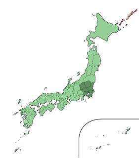
The Jōshin'etsu region is a region on the main Japanese island of Honshu, comprising parts of Gunma, Nagano, and Niigata Prefectures. It is a mountainous area with a large national park and numerous hot springs and ski resorts. It has long been a transportation corridor between the Kantō plain and coastal areas on the Japan Sea side of the island.

References

  1. Ministry of Land, Infrastructure and Transport, Kanto Regional Development Bureau. "Road Timetable". Archived from the original on 2008-04-26. Retrieved 2008-04-16.CS1 maint: Multiple names: authors list (link)
  2. "Expressway Opening Dates" . Retrieved 2008-04-16.
  3. Ministry of Land, Infrastructure and Transport. "High Standard Trunk Road Map" (PDF). Archived from the original (pdf) on 2011-09-20. Retrieved 2008-04-13.
  4. "E-NEXCO Opening Schedule" . Retrieved 2008-04-15.
  5. Nagasaki University Geo-Environment Laboratory. "Kanetsu Tunnel". Archived from the original on 2008-04-08. Retrieved 2008-04-16.
  6. Japan Civil Engineering Contractors Association. "Construction History of Japan, 1985". Archived from the original on 2008-04-29. Retrieved 2008-04-16.