Related Research Articles

Vidarbha is the north-eastern region of the Indian state of Maharashtra, comprising Nagpur Division and Amravati Division. Amravati division's former name is Berar. It occupies 31.6% of the total area and holds 21.3% of the total population of Maharashtra. It borders the state of Madhya Pradesh to the north, Chhattisgarh to the east, Telangana to the south and Marathwada and Khandesh regions of Maharashtra to the west. Situated in central India. The largest city in Vidarbha is Nagpur followed by Amravati. A majority of Vidarbhians speak Varhadi and Zadi dialects of Marathi.

The Satpura Range is a range of hills in central India. The range rises in eastern Gujarat state running east through the border of Maharashtra and Madhya Pradesh to the east till Chhattisgarh. The range parallels the Vindhya Range to the north, and these two east-west ranges divide Indian Subcontinent into the Indo-Gangetic plain of northern India and the Deccan Plateau of the south. The Narmada River originates from north-eastern end of Satpura in Amarkantak, and runs in the depression between the Satpura and Vindhya ranges, draining the northern slope of the Satpura range, running west towards the Arabian Sea. The Tapti River originates in the eastern-central part of Satpura, crossing the range in the center and running west at the range's southern slopes before meeting the Arabian Sea at Surat, draining the central and southern slopes of the range. Multai, the place of Tapi river origin is located about 465 kilometer far, south-westerly to Amarkantak, separated across by the hill range. The Godavari River and its tributaries drain the Deccan plateau, which lies south of the range, and the Mahanadi River drains the easternmost portion of the range. The Godavari and Mahanadi rivers flow into the Bay of Bengal. At its eastern end, the Satpura range meets the hills of the Chotanagpur Plateau. The Satpura Range is a horst mountain and is flanked by Narmada Graben in the north and much smaller but parallel Tapi Graben in the south.

The Mudumalai National Park and Wildlife Sanctuary also a declared tiger reserve, lies on the northwestern side of the Nilgiri Hills, in Nilgiri District, about 150 kilometres (93 mi) north-west of Coimbatore city in Tamil Nadu, India. It shares its boundaries with the states of Karnataka and Kerala. The sanctuary is divided into five ranges – Masinagudi, Thepakadu, Mudumalai, Kargudi and Nellakota.

National Chambal Sanctuary, also called the National Chambal Gharial Wildlife Sanctuary, is a 5,400 km2 (2,100 sq mi) tri-state protected area in northern India for the protection of the Critically Endangered gharial, the red-crowned roof turtle and the Endangered Ganges river dolphin. Located on the Chambal River near the tripoint of Rajasthan, Madhya Pradesh and Uttar Pradesh, it was first declared in Madhya Pradesh in 1978, and now constitutes a long narrow eco-reserve co-administered by the three states. Within the sanctuary, the pristine Chambal River cuts through mazes of ravines and hills with many sandy beaches.

Dachigam National Park is located 22 kilometers from Srinagar, Jammu and Kashmir. It covers an area of 141 km2. The name of the park literally stands for "ten villages" which could be in memory of the ten villages that were relocated for its formation. These ten villages were living in this region before the World War I the beginning of the early 20th century. The main gate entrance is very close to the New Theed general bus stand on the either side of Darul Uloom Kousaria.

Sultanpur National Park is located at Sultanpur village on Gurugram-Jhajjar highway, 15 km from Gurugram, Haryana and 50 km from Delhi in India. This covers approximately 142.52 hectares.

Vansda National Park, also known as Bansda National Park, is a protected area which represents the thick woodlands of the Dangs and southern Gujarat, and is situated in the Vansda tehsil, Navsari District of Gujarat State, India. Riding on the banks of Ambika River and measuring roughly 24 km2 in area, the park lies about 65 km east of the town of Chikhali on the National Highway 8, and about 80 km north-east of the city of Valsad. Vansda, the town from which the name of the park is derived, is an important trading place for the surrounding area where the majority of the population is represented by adivasis. Vansda-Waghai state highway runs through the park, so does the narrow gauge rail link connecting Ahwa to Billimora.

The Narmada Valley dry deciduous forests are a tropical dry forest ecoregion of central India. The ecoregion lies mostly in Madhya Pradesh state, but extends into portions of Chhattisgarh, Maharashtra, and Uttar Pradesh states.

The forest owlet is endemic to the forests of central India. It is listed as Endangered on the IUCN Red List since 2018, as the population is estimated at less than 1,000 mature individuals. It is threatened foremost by deforestation.
The Central Highlands of India are a biogeographic region in India formed by the disjunct ranges of the Satpura and Vindhya Hills. It is given the term 6A within the Deccan zone in the Rodgers and Panwar (1988) classification. The zone adjoins 6D, the Central Plateau and 4B, the Gujarat Rajputana and extends across the states of Maharashtra, Madhya Pradesh and Chhattisgarh. The total area is approximately 250,000 km2 and there are 27 Protected Areas covering 4.9% of the area. There are also six Project Tiger Reserves in the region.

Kuno National Park is a protected area in Madhya Pradesh that received the status of national park in 2018. The protected area was established in 1981 as a wildlife sanctuary with an area of 344.686 km2 (133.084 sq mi) in the Sheopur and Morena districts. It was also known as Kuno-Palpur and Palpur-Kuno Wildlife Sanctuary. It is in the Khathiar-Gir dry deciduous forests ecoregion.
Conservation reserves and community reserves in India are terms denoting protected areas of India which typically act as buffer zones to or connectors and migration corridors between established national parks, wildlife sanctuaries and reserved and protected forests of India. Such areas are designated as conservation areas if they are uninhabited and completely owned by the Government of India but used for subsistence by communities, and community areas if part of the lands are privately owned. Administration of such reserves would be through local people and local agencies like the gram panchayat, as in the case of communal forests.

The word Maharashtra, the land of the Marathi-speaking people, appears to be derived from Maharashtrian, an old form of Prakrit. Some consider it a corruption of the term 'Maha Kantara', a synonym for 'Dandakaranya'. Maharashtra is the third largest state in India after Rajasthan and Madhya Pradesh. It covers an area of 307,713 km2 and is bordered by the states of Madhya Pradesh to the north, Chhattisgarh to the east, Telangana to the southeast, Karnataka to the south and Goa to the southwest. The state of Gujarat lies to the northwest, with the Union territory of Dadra and Nagar Haveli sandwiched between the borders. Maharashtra has coastline of 720 km.The Arabian Sea makes up Maharashtra's west coast. Maharashtra consists of two major relief divisions. The plateau is a part of the Deccan tableland and the Konkan coastal strip abutting on the Arabian Sea.
Radhanagari Wildlife Sanctuary is a wildlife sanctuary and natural World Heritage Site of category ix and x since 2012, located in Kolhapur district, Maharashtra State, India. It lies at the southern end of the Sahyadri hills in the Western Ghats. It is notable as the first declared wildlife sanctuary in Maharashtra, notified in 1958, as "Dajipur Wildlife Sanctuary" and is popularly known as the "Bison Sanctuary". Indian bison or gaur with a population around 1091 in 2014, is the flagship species of the area. It was notified as Radhanagari wildlife sanctuary vide notification No. WLP/1085/CR/588/ V/F-5,Dt.16.9.1985.

Melghat was declared a tiger reserve and was among the first nine tiger reserves notified in 1973-74 under the Project Tiger. It is located at 21°26′45″N77°11′50″E in northern part of Amravati District of Maharashtra State in India. The Tapti River and the Gawilgadh ridge of the Satpura Range form the boundaries of the reserve. In 1985, Melghat Wildlife Sanctuary was created. The Tapi river flows through the northern end of the Melghat Tiger Reserve, through a forest which lies within the catchment area of the river system. There are different kinds of wildlife species both flora and fauna are found here.

Sunabeda Wildlife Sanctuary is a wildlife sanctuary and a proposed tiger reserve located in the Nuapada district of Odisha, adjoining Chhattisgarh. It has a total area of 600 km2 (230 sq mi). The sanctuary harbours a great diversity of wildlife habitats, with a vast plateau, multiple valleys, gorges and magnificent waterfalls. The sanctuary forms the catchment area of the Jonk River, over which a dam has been constructed to facilitate irrigation. The Indra nullah and Udanti River lies to the south of the sanctuary. The important vegetation of the site comprises dry deciduous tropical forest.

The Central Asian Flyway (CAF), Central Asian-Indian Flyway, or Central Asian-South Asian Flyway is a flyway covering a large continental area of Eurasia between the Arctic Ocean and the Indian Ocean and the associated island chains. The CAF comprises several important migration routes of waterbirds, most of which extend from the northernmost breeding grounds in Siberia to the southernmost non-breeding wintering grounds in West Asia, India, the Maldives and the British Indian Ocean Territory.
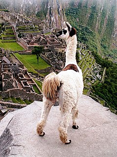
Peru has some of the greatest biodiversity in the world. It belongs to the select group of mega diverse countries because of the presence of the Andes, Amazon rainforest, and the Pacific Ocean. It has the fourth-most tropical forests of any country and the ninth-most forest area.

Nauradehi Wildlife Sanctuary, covering about 1,197 km2 (462 sq mi), is the largest wildlife sanctuary of Madhya Pradesh state in India. This wildlife sanctuary is a part of 5500 km2 of forested landscape. It is located in the centre of the state covering parts of Sagar, Damoh, Narsinghpur, and Raisen Districts. It is about 90 km from Jabalpur and about 56 km from Sagar.
lulu
References
- ↑ s075 Central Indian forests (secondary area) BirdLife International, Retrieved 22 August 2015