
Central Swindon North is a civil parish in the borough of Swindon, Wiltshire, England. [1]
Central Swindon North is a civil parish in the borough of Swindon, Wiltshire, England. [1]
The parish of Central Swindon North was created in 2017, [2] alongside Central Swindon South (later renamed to South Swindon).
In 2022, the council opened a new accessible play park at Pinetrees Community Centre. [3]
As its name suggests, the parish covers the northern half of the central area of the town, the east–west railway line separating it from South Swindon parish. Areas within the parish include Even Swindon, Rodbourne, Moredon, Pinehurst, Penhill and Gorse Hill. [4] The River Ray, a minor river flowing north to join the Thames, forms part of the western boundary of the parish. [4]
The population of the parish was 36,834 at the 2021 census. [5]
The parish spans three wards which each elect three members of Swindon Borough Council: [6] Gorse Hill and Pinehurst, Rodbourne Cheney, and the eastern half of Mannington and Western. [4]
For Westminster elections, Central Swindon North is part of the Swindon North constituency.
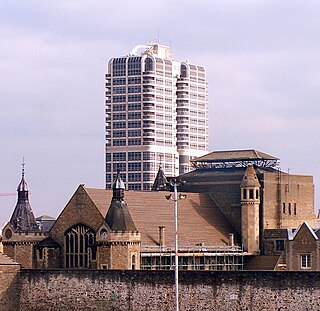
Landmarks in the parish include:

Swindon is a town in Wiltshire, England. At the time of the 2021 Census the population of the built-up area was 183,638, making it the largest settlement in the county. Located in South West England, Swindon lies on the M4 corridor, 71 miles (114km) to the west of London and 36 miles to the east of Bristol. The Cotswolds lie just to the town's north and the North Wessex Downs to its south.

Trowbridge is the county town of Wiltshire, England; situated on the River Biss in the west of the county, close to the border with Somerset. The town lies 8 miles (13 km) south-east of Bath, 31 miles (50 km) south-west of Swindon and 20 miles (32 km) south-east of Bristol. The parish had a population of 37,169 in 2021.

Chippenham is a market town in north-west Wiltshire, England. It lies 13 miles (21 km) north-east of Bath, 86 miles (138 km) west of London and is near the Cotswolds Area of Outstanding Natural Beauty. The town was established on a crossing of the River Avon, where some form of settlement is believed to have existed since before Roman times. It was a royal vill and probably a royal hunting lodge, under Alfred the Great. The town continued to grow when the Great Western Railway arrived in 1841. It had a population of 36,548 in 2021.
The Borough of Swindon is a unitary authority area with borough status in Wiltshire, England. Centred on Swindon, it is the most north-easterly district of South West England.

Cricklade is a town and civil parish on the River Thames in north Wiltshire, England, midway between Swindon and Cirencester. It is the first downstream town on the Thames. The parish population at the 2011 census was 4,227.

Blunsdon is a civil parish in the Borough of Swindon, in Wiltshire, England, about 4 miles (6 km) north of the centre of Swindon, with the A419 forming its southern boundary. Its main settlement is the village of Broad Blunsdon, with Lower Blunsdon nearby; the hamlet of Broadbush is now contiguous with Broad Blunsdon.

Swindon North is a constituency represented in the House of Commons of the UK Parliament since 2024 by Will Stone, a Labour politician.

Swindon South is a constituency in the Borough of Swindon, Wiltshire, represented in the House of Commons of the UK Parliament since 2024 by Heidi Alexander of the Labour Party.

The civil parish of Haydon Wick is a northern suburb of the town of Swindon, Wiltshire, in England. It had a population of 25,036 at the 2021 census. The parish includes the former hamlet of Haydon and the suburbs of Greenmeadow and Rodbourne Cheney.

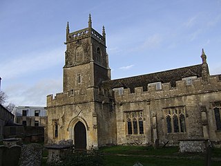
The Church of St. Augustine is an Anglican parish church in Even Swindon, an area of the town of Swindon, Wiltshire, England. The church was built in 1907 to serve the spiritual needs of people moving to Swindon for employment at the Great Western Railway Works. It is in the Diocese of Bristol and the province of Canterbury, and is dedicated to St. Augustine of Canterbury.
Lydiard Tregoze is a small village and civil parish on the western edge of Swindon in the county of Wiltshire, in the south-west of England. Its name has in the past been spelt as Liddiard Tregooze.

The Oasis Leisure Centre was an entertainment and sports complex just outside the town centre of Swindon, Wiltshire, England, with facilities including a lagoon swimming pool, gym, bar, and concert hall. It was in operation from 1976 to 2020.

Malmesbury is a town and civil parish in north Wiltshire, England, which lies approximately 14 miles (23 km) west of Swindon, 25 miles (40 km) northeast of Bristol, and 9 miles (14 km) north of Chippenham. The older part of the town is on a hilltop which is almost surrounded by the upper waters of the Bristol Avon and one of its tributaries.

Rodbourne is a suburb of Swindon in Wiltshire, England, north of the town centre and about 0.9 miles (1.4 km) northwest of Swindon railway station. It includes an area formerly called Even Swindon.

St Paul Malmesbury Without is a civil parish surrounding Malmesbury, Wiltshire, England. Its main settlements are the village of Corston and the hamlets of Milbourne and Rodbourne.

South Swindon, formerly Central Swindon South, is a civil parish in the town of Swindon, in the ceremonial county of Wiltshire, England. The parish covers the southern part of the central area of the town, including the Old Town area, and extends south to take in Wichelstowe and Coate Water. In 2021 it had a population of 62,871.

West Swindon is a civil parish in the borough of Swindon, Wiltshire, England. In 2021 it had a population of 26,846.
| | This article about a location in Wiltshire is a stub. You can help Wikipedia by expanding it. |