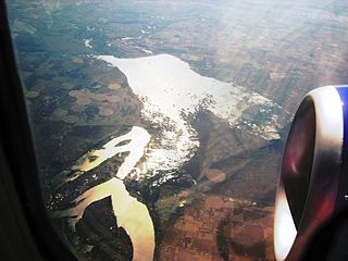
The Yakima River is a tributary of the Columbia River in south central and eastern Washington state, named for the indigenous Yakama people. The length of the river from headwaters to mouth is 214 miles (344 km), with an average drop of 9.85 feet per mile (1.866 m/km). It is the longest river entirely in Washington state.
Interstate 82 (I-82) is an Interstate Highway in the Pacific Northwest region of the United States that travels through parts of Washington and Oregon. It runs 144 miles (232 km) from Ellensburg, Washington, to Hermiston, Oregon, passing through Yakima and the Tri-Cities. The highway also connects I-90 and I-84, which continue to Seattle and Boise, Idaho, respectively.
Moses Lake is a city in Grant County, Washington, United States. The population was 20,366 as of the 2010 census. Moses Lake is the largest city in Grant County. The city anchors the Moses Lake Micropolitan area, which includes all of Grant County, and is part of the Moses Lake-Othello combined statistical area.

The Burlington Northern Railroad was a United States-based railroad company formed from a merger of four major U.S. railroads. Burlington Northern operated between 1970 and 1996.
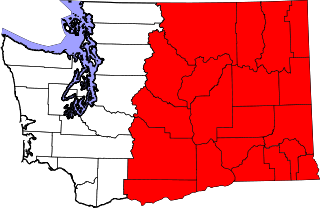
Eastern Washington is the portion of the US state of Washington east of the Cascade Range. The region contains the city of Spokane, the Tri-Cities, the Columbia River and the Grand Coulee Dam, the Hanford Nuclear Reservation and the fertile farmlands of the Yakima Valley and the Palouse. Unlike in Western Washington, the climate is dry, including some desert environments.

Central Washington is a region of the U.S. state of Washington between the western and eastern parts of the state extending from the border with the Canadian province of British Columbia in the north to the border with the U.S. state of Oregon in the south. Generally, the western edge is the Cascade Range and the eastern edge is in the vicinity of the 119th meridian west.

The Spokane, Portland & Seattle Railway (SP&S) was a United States-based railroad incorporated in 1905. It was a joint venture by the Great Northern Railway and the Northern Pacific Railway to build a railroad along the north bank of the Columbia River. Remnants of the line are currently operated by BNSF Railway and the Portland and Western Railroad.
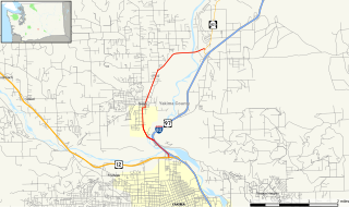
State Route 24 (SR 24) is a state highway in the south-central region of Washington, in the United States. It travels 79 miles (127 km) from Yakima to Othello, across a portion of the Columbia Plateau. The highway crosses the Columbia River on the Vernita Bridge, located near the Hanford Site. SR 24 terminates to the west at an interchange with Interstate 82 (I-82) in Yakima and to the east at SR 26 in Othello.

The Alexandria Canal was a canal in the United States that connected the city of Alexandria to Georgetown in the District of Columbia.
State Route 240 (SR 240) is a state highway in the U.S. state of Washington. It travels diagonally from northwest to southwest within Benton County, serving the Hanford Nuclear Reservation and the Tri-Cities region. The highway begins at a junction with SR 24 and travels around Richland on a limited-access bypass. From there, it briefly overlaps Interstate 182 (I-182) and continues southeast as a freeway along the Columbia River into Kennewick, terminating at an interchange with U.S. Route 395 (US 395). SR 240 is one of the busiest highways in the Tri-Cities region, with a daily average of 76,000 vehicles on a section crossing the Yakima River Delta.
Kiona is an unincorporated community in Benton County, Washington, United States. Kiona is a term belonging to North American indigenous people meaning "brown hills." Kiona and Benton City share a school district.
State Route 823 (SR 823) is a state highway in Yakima County, Washington, United States. It runs for 5.6 miles (9.0 km) from an interchange with U.S. Route 12 (US 12) and through the city of Selah to a junction with SR 821. The highway intersects and runs in the median of Interstate 82 (I-82), its parent route.

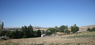
The Horse Heaven Hills are a long range of high, rolling hills in Klickitat, Yakima, and Benton counties in Washington. The hills are an anticline ridge in the Yakima Fold Belt formed by north–south compression of lava flows in the Columbia River Basalt Group. The highest point is Bickleton Ridge in the west end of the hills. They lie within the rain shadow to the east of the Cascade Range, making them significantly drier and hotter than regions west of the Cascades.

Keechelus Lake is a lake and reservoir in the northwest United States, near Hyak in Kittitas County, Washington. Approximately fifty miles (80 km) southeast of Seattle and a few miles southeast of Snoqualmie Pass, it is the source of the Yakima River.
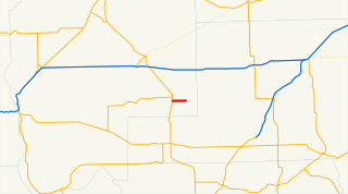
State Route 170 (SR 170) is a short, 3.68-mile (5.92 km) long state highway located within Grant County in the U.S. state of Washington. The highway begins at SR 17 west of Warden and travels east to end at Main Street in Warden. The current route of the highway was first established in 1967 as Secondary State Highway 11I (SSH 11I) and became SR 170 in 1970 after it was moved north of its previous route, which had been on maps since 1926, named SSH 11A in 1937 and renumbered to SR 170 in 1964. The old route ran from the Columbia River southwest of Basin City to SR 17 north of Mesa.
In the U.S. state of Washington, U.S. Route 97 is a 322-mile (518 km) route which traverses from the Oregon state line at the northern end of the Sam Hill Memorial Bridge in Maryhill, north to the Canada–US border in Okanogan County near Oroville. The highway serves major cities such as Goldendale, Yakima, Ellensburg and Wenatchee before continuing towards the Alaska Highway at the Yukon border as British Columbia Highway 97. Along the length of the roadway, US 97 is concurrent with State Route 14 in Maryhill, Interstate 82 (I-82) and US 12 between Union Gap and Ellensburg, I-90 briefly in Ellensburg, US 2 between Peshastin and rural Douglas County and SR 20 near Omak. An alternate route connects the highway with Chelan.

Eltopia is an unincorporated community in Franklin County, Washington, United States, located about 15 miles north of Pasco, along U.S. Route 395.
The Columbia Basin Railroad (CBRR) is a common freight carrier that operates between Ephrata and Connell in the state of Washington, USA.
The Yakima River Delta is an area of land in Richland, Washington where the Yakima River enters the Columbia River at River Mile 335. It hosts several protected areas and is crossed by State Route 240. This area is mostly floodplain with riparian-type growth, including non-native species such as Russian olive. Amon Creek enters the Yakima River in this area.