
Ourense is a province of Spain, in the southeastern part of the autonomous community of Galicia. It is bordered by the provinces of Pontevedra to the west, Lugo to the north, León and Zamora, to the east, and by Portugal to the south. With an area of 7,278 square km., it is the only landlocked province in Galicia. The provincial capital, Ourense, is the largest population centre, with the rest of the province being predominantly rural.

The Pan-American Highway is a network of roads stretching across the Americas, measuring about 30,000 kilometres (19,000 mi) in total length. Except for a break of approximately 100 km (60 mi) across the border between Colombia and Panama, the roads link most of the Pacific coastal countries of North America and South America in a connected highway system. According to Guinness World Records, the Pan-American Highway is the world's longest "motorable road".

Frumales is a municipality in the province of Segovia, Spain. It has a population of 130 registered residents and covers an area of 28 km². It is within the regions of the Land of Pine Groves and the Community of Town and Land of Cuéllar. The terrain is made mostly of pine forests and cultivated fields, although farming is no longer the backbone of its economy, instead being reliant on pensions and the work of neighboring towns. Its main attractions are the Cerquilla River, the Windmill of the Aldehuela, and the Giant Old Elm.

The R25 is a provincial route in South Africa that connects Johannesburg with Groblersdal via Kempton Park, Bapsfontein and Bronkhorstspruit.

The R82 is a provincial route in South Africa that connects Johannesburg with Kroonstad via Vereeniging and Sasolburg. It starts just south of the M1 Johannesburg Municipal Highway's interchange with the N12 Southern Bypass, going south, meeting the R59, R54, R42 & R28 routes at Vereeniging before crossing the Vaal River into the Free State & proceeding to Kroonstad. It is an alternative, but longer route to the N1 National Route between Johannesburg & Kroonstad.

Villanueva de la Cañada is a municipality in the Community of Madrid, Spain. Located 30 km north-west from Madrid, the municipality covers an area of 34.92 km2. Geographically, it sits on a large plain, in which there are several promontories, on one of which is found the castle of Aulencia, its main landmark. The ESA's European Space Astronomy Centre lies close to the former, on the Guadarrama riverfront. Villafranca del Castillo, a well-off urban area detached from the main nucleus, is located within the municipal bounds. Villanueva de la Cañada hosts the main campus of the Alfonso X El Sabio University as well as the Aquópolis waterpark.
Soto del Real, whose former name was Chozas de la Sierra, is a town and municipality in the northern area of the autonomous Community of Madrid which had 9,188 inhabitants in 2022.

The N12 is a national route in South Africa which runs from George through Beaufort West, Kimberley, Klerksdorp and Johannesburg to eMalahleni.

Vermont Route 114 (VT 114) is a 53.094-mile-long (85.447 km) north–south state highway in northeastern Vermont in the United States. It runs northward from U.S. Route 5 (US 5) in Lyndon until nearing the Canada–United States border in the town of Norton; thereafter, the road continues east to the New Hampshire state line in Canaan. The vast majority of VT 114 is situated within Essex County; however, the route also passes through small, isolated portions of Caledonia and Orleans Counties.

Aldeadávila de la Ribera is a village and municipality in the north-west of the province of Salamanca, western Spain, part of the autonomous community of Castile and León.
The N-122 is a highway in Spain. It connects Valladolid and Zaragoza to the Portugal–Spain border, where it connects to the A4 motorway (Portugal), this section was formerly the IP-4 and is now part of the European route E82 to Matosinhos. The border is formed by the Rio Macãs it heads east crossing the Esla river to Zamora and the Duero river valley. The N-630 crosses to the north and south.
Pinet is a municipality located in the north-east of the comarca of Vall d'Albaida in the south of the province of Valencia, Valencian Community, Spain, and some 82.6 km from the regional capital, Valencia.

Puente Aranda is the 16th location of the Capital District of the Colombian capital city, Bogotá. It is located in the center part of Bogotá. This district is mostly inhabited by lower middle and working class residents. The district was named after an old bridge in the hacienda of Juan Aranda over the "Chinúa River", now called the San Francisco River, that dates to the 16th century. Puente Aranda has 1,724 hectares of area which are almost entirely urban. This locality has more than 300,000 inhabitants, 5% of the total urban area inhabitants of Bogota.

Navarrevisca is a municipality in the south of the province of Ávila, Castile and León, Spain, located 48 kilometers from the provincial capital. It has a population of 279 inhabitants.
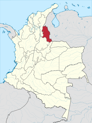
North Santander is a department of Northeastern Colombia. It is in the north of the country, bordering Venezuela. Its capital is Cúcuta, one of the country's major cities.
Federal Highway 95 connects Mexico City to Acapulco, Guerrero. The Autopista del Sol is a tolled alternative, which bypasses several towns of the state of Guerrero, including the city Iguala, and thus reduces transit time between Acapulco from Mexico city from 8 hours to almost 3.5 hours.

Río Portugués is a river in the municipality of Ponce, Puerto Rico. In the 19th century, it was also known as Río de Ponce. Twenty-one bridges for motor vehicle traffic span Río Portugués in the municipality of Ponce alone. The river is also known as Río Tibes in the area where it flows through barrio Tibes in the municipality of Ponce. Río Portugués has a length of nearly 30 kilometers (19 mi) and runs south from the Cordillera Central mountain range into the Caribbean Sea. The Portugués is one of the best-known rivers in Ponce because of its prominent zigzagging through the city and its historical significance. The river is historically significant because the city of Ponce had its origins on its banks. It was originally known as Río Baramaya. It has its mouth at 17°58′51″N66°37′26″W. This river is one of the 14 rivers in the municipality.

State Route 161 (SR 161) is part of Maine's system of numbered state highways. It runs 86 miles (138 km) from Fort Fairfield to Allagash. It begins at the Fort Fairfield–Andover Border Crossing along the Canada–US border to Dickey Road near the confluence of the Allagash and Saint John rivers.
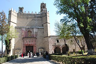
Huejotzingo is a small city and municipality located just northwest of the city of Puebla, in central Mexico. The settlement's history dates back to the pre-Hispanic period, when it was a dominion, with its capital a short distance from where the modern settlement is today. Modern Huejotzingo is located where a Franciscan monastery was founded in 1525, and in 1529, the monks moved the indigenous population of Huejotzingo to live around the monastery. Today, Huejotzingo is known for the production of alcoholic apple cider and fruit preserves, as well as its annual carnival. This carnival is distinct as it centers on the re-enactment of several historical and legendary events related to the area. The largest of these is related to the Battle of Puebla, with about 2, 000 residents representing French and Mexican forces that engage in mock battles over four days.

The Carraixet ravine is a course of water from the north of the Valencian province, in the Valencian Community (Spain). It begins in Gátova and collects waters from the sloped southern side of the Calderona mountain range. It flows into the Mediterranean Sea through the town of Alboraya. At its mouth, it is also called the Olocau ravine or the Peralvillo ravine. In the Book of the Facts James I named it riu Sec, while discussing the Battle of the Puig.
